 | Zavrh pri Trojanah - Limbarska gora (via Golčaj)
Limbarska gora is located northeast of Moravče. From the summit, there is a beautiful view of the surrounding peaks, and in good weather, the Kam...
3 h 30 min |
 | Predmeja - Sinji vrh (Pot po Robu)
Sinji vrh is a panoramic mountain between Col, Ajdovščina, and Predmeja. It offers views across much of western Slovenia (the sea on clear days)....
2 h 55 min |
 | Šentvid pri Planini - Skalica (Bohor) (via Veliki Javornik)
Skalica is a lesser-known peak on the western part of Bohor. From the summit, which has a logbook box, there is a nice view to the south and west...
3 h |
 | Mislinja - Črepič (circular path)
Črepič is an 798-meter-high peak west of Mislinja. The summit is forested and offers no view, but there is an expansive panorama from a nearby me...
3 h 30 min |
 | Ledinsko Razpotje - Medvedje Brdo (east path)
Medvedje Brdo is a small settlement located north of Hotedršica. The highest point of the village is a pleasant viewpoint on Šinkovcov grič (814 ...
3 h 10 min |
| Ledinsko Razpotje - Medvedje Brdo (west path)
Medvedje Brdo is a small settlement located north of Hotedršica. The highest point of the village is a pleasant viewpoint on Šinkovcov grič (814 ...
3 h 15 min |
 | border crossing Remšnik - Kapunar / Kapunerkogel (via Sveti Urban)
Kapunar is a 1,051-meter-high peak above Radlje ob Dravi. Just below the summit stands an old customs post and border guardhouse, now used by ama...
2 h 20 min |
 | Trojane - Špilk
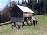
Špilk is a 956 m high peak located north of Blagovica. At the mostly forested summit, PD Blagovica has set up a small bivouac with a bench and ta...
2 h 30 min |
 | Planina pri Sevnici - Debeli vrh (Bohor)
Debeli vrh is a 921-meter-high peak on Bohor between Veliki Koprivnik and Oslica. Covered in dense forest, it offers no views. A marked hiking tr...
2 h 30 min |
 | Planina pri Sevnici - Brest (Bohor) (via Škofov travnik)
Brest is a peak on Bohor, though it resembles more of a saddle. It is an important trail junction on Bohor, lying between more easterly Oslica an...
2 h 35 min |
| Planina pri Sevnici - Brest (Bohor) (northern path)
Brest is a peak on Bohor, though it resembles more of a saddle. It is an important trail junction on Bohor, lying between more easterly Oslica an...
2 h 20 min |
 | 18th hairpin turn of road on Strma Reber - Loška stena
Loška stena rises above Zgornja Kolpska dolina, more precisely above the villages of Grintovec pri Osilnici, Ložec, and Ribjek. From the summit o...
2 h 25 min |
 | Koča pri Jelenovem studencu - Slovenski vrh
Slovenski vrh is a 1,041-meter-high mountain located in the ridge of Stojna, which lies between Kočevska Reka and Kočevje. The peak, a control po...
3 h |
 | Sveti Jurij (Remšnik) - Sršenov vrh
Sršenov vrh is a 963-meter-high peak located in the Kozjak hills, more precisely between Ožbalt and Zgornja Kapla. The summit itself offers no sp...
3 h 30 min |
 | border crossing Remšnik - Tolsti vrh (on Kozjak) (Slovenian way)
Tolsti vrh is a 756-meter-high peak on Kozjak, located on the Austria-Slovenia border north of Zgornja Kapla settlement. The summit lies in fores...
2 h 30 min |
 | Planina pri Sevnici - Ješivec
Ješivec (also Ješivc) is a 934-meter-high peak in Posavsko hribovje, from which a beautiful view opens up mainly to the south and west, while for...
3 h 40 min |