 | Žlebe - Sveti Jakob (via Turnice)
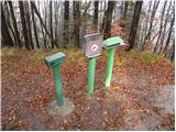
The Church of St. James is located on a scenic hill north of the village of Topol pri Medvodah. From the summit, which features a registration bo...
2 h |
 | Slavkov dom na Golem Brdu - Sveti Jakob
The Church of St. James is located on a scenic hill north of the village of Topol pri Medvodah. From the summit, which features a registration bo...
2 h 5 min |
 | Mengeška koča na Gobavici - Rašica (Vrh Staneta Kosca) (ridge path)
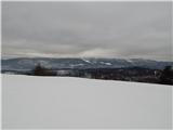
Vrh Staneta Kosca, better known as Rašica, is located north of Ljubljana, more precisely above the villages of Rašica and Dobeno. From the summit...
2 h |
 | Mengeška koča na Gobavici - Rašica (Vrh Staneta Kosca) (lower path)
Vrh Staneta Kosca, better known as Rašica, is located north of Ljubljana, more precisely above the villages of Rašica and Dobeno. From the summit...
2 h |
 | Vače - Zasavska Sveta gora
Zasavska Sveta Gora is a popular excursion destination located between Litija and Izlake. From the summit, where the parish church of the Nativit...
2 h |
 | Vače - Zasavska Sveta gora (on a slope)
Zasavska Sveta Gora is a popular excursion destination located between Litija and Izlake. From the summit, where the parish church of the Nativit...
2 h 30 min |
 | Veliko Trebeljevo - Janče
Janče is a 792-meter-high peak situated between the Sava River and the Besnica stream valley. From the summit, where a mountain hut stands and th...
2 h 15 min |
 | Katarija - Slivna (Pivkelj)
Slivna, also known as Pivkelj (or Pivkelj turn), lies south of Limbarska gora. Pivkelj is the highest point of the Moravška planinska pot and at ...
1 h 55 min |
 | Kandrše (Trata) - Slivna (Pivkelj) (via Sveti Florjan)
Slivna, also known as Pivkelj (or Pivkelj turn), lies south of Limbarska gora. Pivkelj is the highest point of the Moravška planinska pot and at ...
2 h 20 min |
| Kandrše (Trata) - Slivna (Pivkelj) (via GEOSS)
Slivna, also known as Pivkelj (or Pivkelj turn), lies south of Limbarska gora. Pivkelj is the highest point of the Moravška planinska pot and at ...
2 h |
 | Črni hribi - Trstelj
Trstelj is the highest peak in the ridge of Črni hribi. From the spacious summit, which has TV transmitters, the view is divided. From the north ...
2 h |
 | Skadanščina - Velika Plešivica
Velika Plešivica is a 908-meter peak located between Slavnik and the lesser-known Mala Plešivica. The summit, which features a destroyed logbook ...
2 h 15 min |
 | Dule - Grmada on Mala gora
Grmada (also Grmada above Ortnek) is an 887-meter-high peak located above the village of Vrh pri Poljanah in the Mala Gora range. Just a few mete...
2 h |
 | Grčarevec - Grmada (Planinska gora) (Jakobova pot)
Grmada is an 873-meter-high peak rising west of Planinsko polje. Although the summit is forested, a viewpoint just below it offers a stunning vie...
1 h 50 min |
 | Ledinsko Razpotje - Medvedje Brdo (east path)
Medvedje Brdo is a small settlement located north of Hotedršica. The highest point of the village is a pleasant viewpoint on Šinkovcov grič (814 ...
3 h 10 min |
| Ledinsko Razpotje - Medvedje Brdo (west path)
Medvedje Brdo is a small settlement located north of Hotedršica. The highest point of the village is a pleasant viewpoint on Šinkovcov grič (814 ...
3 h 15 min |
 | Zavrh pri Trojanah - Golčaj
Golčaj is a 690 m high hill rising south of Blagovica. At the summit, which has a logbook box and stamp, stands a NOB monument; a few tens of met...
2 h 30 min |
 | Mislinja - Fričev vrh (via Završe)
Fričev vrh is an 881 m high hill located south of Mislinjska Dobrava. From the summit, which has a logbook box with book and stamp inside, there ...
2 h |
 | Šembije - Ahac
Ahac (or Sv. Ahac) is a 799-meter-high peak located east of Ilirska Bistrica. The summit hosts a summit logbox, a cross, and ruins of the former ...
2 h |
 | Šentvid pri Planini - Debeli vrh (Bohor)
Debeli vrh is a 921-meter-high peak on Bohor between Veliki Koprivnik and Oslica. Covered in dense forest, it offers no views. A marked hiking tr...
2 h |
 | Planina pri Sevnici - Brest (Bohor) (northern path)
Brest is a peak on Bohor, though it resembles more of a saddle. It is an important trail junction on Bohor, lying between more easterly Oslica an...
2 h 20 min |
| Šentvid pri Planini - Brest (Bohor) (via Škofov travnik)
Brest is a peak on Bohor, though it resembles more of a saddle. It is an important trail junction on Bohor, lying between more easterly Oslica an...
2 h 5 min |
| Šentvid pri Planini - Brest (Bohor) (northern path)
Brest is a peak on Bohor, though it resembles more of a saddle. It is an important trail junction on Bohor, lying between more easterly Oslica an...
1 h 50 min |
 | Travnarjev gozd (Hotenjsko podolje) - Šenčurjev vrh
Šenčurjev vrh is a 725-meter-high hill located above the settlement of Žibrše, which lies between Logatec, Hotedršica, and Rovte. At the summit, ...
1 h 50 min |
 | Radeljski prelaz - Sveti Pankracij (Radelca) (Austrian path)
The Church of St. Pankracij on Radelca is located at an altitude of 900 meters, directly on the border ridge between Slovenia and Austria. The or...
3 h |
 | Prelaz Vrhe - Maceljska gora (via source of Sotla)
Maceljska gora is the highest peak of Macelj, a range located south of the settlement of Žetale along the border with Croatia....
1 h 50 min |
 | Male Drage - Okrugljak (via Razdrto)
Okrugljak is a forested hill located in the eastern part of Gorski Kotar, near the border with Slovenia. The summit was formerly an HPO point (no...
2 h 30 min |