|
|
|
|
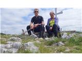 Kucelj KuceljKamnje- Mala gora- Kucelj. Descent on srednječavenska path past hunting lodge Črna peč. It snowed 14...
|
|
|
Commented trips
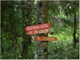 Polje - Planina Osredki Polje - Planina OsredkiOn Saturday I was at Pl. Osredki, but from Raven - the path joins this one from Polj in the last hou...
|
|
|
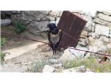 Birds BirdsThe little sparrow finally wove itself a nest after a good month of work. In the stable....
|
|
|
New trips
 Kozje - Grad Kozje (Drachenburg) (strma pot) Kozje - Grad Kozje (Drachenburg) (strma pot)Drachenburg Castle (Dragon Castle) on Bredič, directly above Kozje, was first mentioned in 1286 as castrum Trachenberk but most likely built in the early 12th century, making it one of the oldest cast...
|
|
|
|
|
|
|
|
|
|
|
Random trip
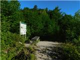
 Koča na Uskovnici Koča na UskovniciThe Koča na Uskovnici mountain hut is located in the central part of the small Uskovnica plateau, between Pokljuka and the Voje valley. Just a good 5 minutes from the hut there is a small chapel offering a beautiful view of the mountains surrounding Bohinj. Between the hut and the chapel, intere...
|
|
|
|
|
|
|