|
| bruny15. 01. 2015 22:48:43 |
On Thursday, 15.01.2015 to RTV tower on Boč from Poljčane center and back. Evening activity, hiking on forest road. Strong wind higher by the tower and on exposed spots along the way. Above 700 meters path snowy for pleasant steps. Easy route, but quite some kilometers...Colleague and neighbor Vinko joined, met no one...
Route:Poljčane/center-Boč/RTV tower and back-evening,15.01.2015
|
|
|
|
| navdušena16. 01. 2015 07:35:27 |
Is the path to the tower icy at all - do you recommend crampons? Or did you really go along the road the whole time (old road to the tower)? Do you know the condition on Detička path?
|
|
|
|
| bruny16. 01. 2015 13:14:56 |
This ROUTE we did yesterday in evening hours...between photos 1...40 and back. Typical cycling but yesterday hiking variant for training. There were a few cm snow on road, probably still from Sunday above 700m. Step was pleasant and some winter touch. Personally walked in low Salomons. For Detička don't know!? but with this westerly blowing ...Yesterday chose route precisely because of wind this, more northern and eastern exposure and wind except few ends where exposure more western not too pronounced.Lp ...Yesterday chose route precisely because of wind this, more northern and eastern exposure and wind except few ends where exposure more western not too pronounced.Lp
|
|
|
|
| strikan16. 01. 2015 18:08:41 |
Navdušena on Detička no mud either, snow taken away. On Tuesday still some for sample today dry. Even via ferrata in use, rock dry.
|
|
|
|
| bruny1. 02. 2015 01:16:36 |
In the evening that fell partly into night, on Saturday, 31.01.2015 from Poljčane to Gril chapel on Cerovec under Grilov hill deep in Rogaška part of Boč, Sv. Marjeta and by highest farms on Boč in Čača village, as three most distant points. From Gril chapel of course Rogaška Slatina reachable in less than an hour but enough. Rang the bell seven times for luck and safe ,,bočko,, paths and return. Paths snowy, up to 7 cm new snow and icy too in real winter fairytale. Moon and stars gave enough light, so headlamps stayed in pockets. Met no one even at nice number of hunting blinds by which we walked there were no bucks, but you never know. Friend and neighbor Vinko joined. Extreme three points mainly his wish, personally in that evening crossing Plešivec to Ravnegacer tempted me more. In frost pockets around Formila very cold. Still it was interesting in whiteness of bright night and 6 relatively demanding hiking hours passed like a puff...
Trasa poti Poljčane - Grilova kapela nad Rogaško Slatino...& nazaj,31.01.2015
| (+1) |  | |
|
|
|
|
| bruny12. 02. 2015 23:23:12 |
Over Boč to sunny side of Boč... but due to evening activity not pronounced. Goal Zgornja Kostrivnica... interesting settlement has lots... Most point surely church Sv. Marija Čenstohovska in settlement center on small hill. After short tour of settlement return back under northern part of Boč. Path easy, mainly unfortunately asphalt base but elsewhere today mainly on Boč snowy slush, although some frozen parts too.
Route... Poljčane - hut on Boč - Zgornja Kostrivnica and back.Lp
|
|
|
|
| Domch19. 02. 2015 16:18:19 |
Today on Boč. Start at LD Rogaška Slatina, summit, Hut under Boč, LD Rogaška Slatina. Path goes far around on road so I cut across somewhere by orientation and then at junction right on marked path to top. Descent straight down by rope to hut - quite military style. Followed walk on road back. Nice day, no wind on top, view very poor. Path partly icy, midday quite melted.
|
|
|
|
| bruny27. 02. 2015 10:48:20 |
In evening activity to bed of Veliki potok under Velika Kopa and of course back to Poljčane. Close here already tripoint between Maribor, Celje and Ptuj areas. Surely least visited part of wider Boč area is along Veliki potok bed. On shortest link between Poljčane and Sveta Ana/Stoperce and further highest Haloze peak - Jelovice. Under Velika Kopa, summit. Yes, quite remote that world. And for evening hour even more. Been there few times - five, six times and today again for solid hiking training. Even hunters, wild boars, foxes… avoid it, let alone hikers. Stream bed quite low but interesting in its way. A bit further two points… Rudeka and Šlog. These two names you won't find anywhere in Slovenia, if not mistaken. From Veliki potok upward directly along roe buck stream bed on forest track inactive for some time. And exit to Ravnocerje plateau in direction of small chapel. Colleague Vinko wanted ascent to Plešivec and continued with ridge crossing on hiking path. Interestingly not trodden and had to wade through 20-30 cm snow practically to abandoned forest ramp under Plešivec/above Gavez. Then by Sv. Marjeta, mountain hut and pasque flower site return to Poljčane. Site not snow covered and its blooming time close. This year Easter early. Mixed bases, muddy, snowy and partly icy. Slightly cloudy, here and there some wind. Best part surely point reaching Veliki potok and Plešivec, kilometers and elevation quite some and pleasant less than six hours, finish few minutes before midnight, in landscape park Boč - Plešivec....
Poljčane - Boč and Plešivec,26.02.2015.Lp
 1 1
|
|
|
|
| Tonyy10. 03. 2015 19:15:20 |
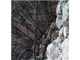
I used today's day off for a walk to the slightly more remote Boč. From the parking lot via Detička on the path over Balunjača over the via ferrata, the climbing part is short but fairly demanding, nice variation...
 1 1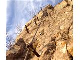 2 2
|
|
|
|
| lesnik1210. 03. 2015 21:52:02 |
Nice addition to the day Tonyy, what are the weather conditions like, is there still any snow as I'm planning to head to Boč on Saturday via the described route.
lp, Lešnik
|
|
|
|
| frajer14. 03. 2015 23:28:27 |
Right at the top there's still a bit of snow left, but the path is completely dry and clear...
Pasque flower already growing ;-)
 1 1
|
|
|
|
| bruny29. 03. 2015 20:09:26 |
To the viewpoint tower on Boč from Studenice via Stara drevesnica. Stara drevesnica is not a peak but an area in the northern part of Boč higher somewhere between/above Studenice and Poljčane. Probably the name due to planned tree planting a century, two, three ago... Nice and interesting area, relatively quiet world, not too crowded and that's just right...
Paths mostly dry, here and there some muddy sections but Boč is a limestone world and water drains quickly... Below in Studenice lots of wild garlic gatherers, higher on Boč at the tower also quite a few visitors...
Route: Studenice - Stara drevesnica - viewpoint tower on Boč and back...,29.03.2015
 1 1
| (+1) | | |
|
|
|
|
| ales2829. 03. 2015 22:13:24 |
Today on Boč 
| (+2) | | |
|
|
|
|
| Kokta29. 03. 2015 22:21:27 |
Great, they are already out
|
|
|
|
| ales2829. 03. 2015 22:23:24 |
Yes, already quite a few, they will still bloom for a while, also temperature will drop so they will still be around for a while, yes There are really lots of them, I don't remember ever seeing so many
|
|
|
|
| bruny11. 04. 2015 20:36:23 |
|
|
|
|
| bruny16. 04. 2015 21:00:58 |
Afternoon hiking from Studenice above the spring through Stara drevesnica and Drevesnica to the eastern ridge of Boč. Reached 775 meters and also informal paths from Makole and Rogaška side along the ridge... Also somewhere passage with help of two unconnected forest tracks between Studenice and Kostrivnica part of Boč is here. Border between municipalities Poljčane and Rogaška Slatina or administrative units Slovenska Bistrica and Šmarje pri Jelšah likewise. I would have been at the top soon but it was quite enough for one Thursday...
Paths dry, met no one except small herd of mouflons and on return night was already chasing me...
Route:Boč above Studenice/studeniško-kostrivniški passage,16.04.2015.Lp
|
|
|
|
| bruny20. 04. 2015 11:01:52 |
No Boč summit planned, nor any of the other lower peaks in hiking pace on Sunday 19.04.2015. Razpotje Hrastovec pod Bočem goal from Studenice. In somewhat stretched activity gathering mileage and elevation. Up from Studenice, to feeding stations and left variant of path directly below Stara drevesnica. Junction with road to tower and short descent down to clearing Formilo. There connection to official mountain path to Makole, which I followed between higher Kisovec on left and Stavski/Thick summit on right... and soon junction with forest road, some tens of meters extension and Razpotje Hrastovec pod Bočem reached... Short break and return on identical route back... Pleasant, some kilometers and also elevation meters, somewhere for basic stretch. Mostly walking, running... due to peaks - here and there even seemingly some more obscure point in interesting combination quite enough...Route... Boč between Studenice and razpotje Hrastovec pod Bočem,19.04.2015. Saturday rain didn't soak the path too much, sunny and no wind. But could feel relatively low Sunday morning temperature still in afternoon hours in Boč forests. Lp
|
|
|
|
| bruny26. 04. 2015 22:05:23 |
Basic goal in landscape park Boč & Plešivec 679 meters high summit Ravnocerje... better known plateau with its name below the summit and farm Plavčak... called locally ,,Ranciršek,, with enclosure for deer or small game. From summit some views and two, three years ago right on top a giant beech was felled. Summit is near mountain path Boč - Donačka gora, about 200 meters from path and less visited. Today third time maybe fourth on this summit. On return back to Studenice also to razpotje Hrastovec pod Bočem for one Ypsilon path impression. Highest point of whole route was 822 meters high Plešivec and ridge traverse both directions, today this right one. Paths today dry, sunny and quite windy...
Route...Studenice - Ravnocerje/summit679 - razpotje Hrastovec pod Bočem and back,26.04.2015 Lp
|
|
|
You must log in to post a comment:
If you do not yet have a username, you must first
register.