Kokrska and Jezerska Kočna
|
| garmont6. 08. 2024 18:37:54 |
The path from Jezerska Kočna to the junction for Dolce is normally passable. Further towards Grintovec (Špremova pot) it is closed.
| (+2) |  | |
|
|
|
|
| lijaneja6. 08. 2024 18:47:20 |
Under the topic 'Grintovec' this debate is currently running.
|
|
|
|
| Pero_247. 08. 2024 08:36:33 |
@prostipad, the path from the saddle first to Kokrska then to Jezerska Kočna and back is open, as garmont mentions - towards Grintovec that part which is closed.
| (+1) | | |
|
|
|
|
| prostipad8. 08. 2024 14:49:29 |
Thanks for the information.
|
|
|
|
| patrik_mihajlov28. 09. 2024 09:14:32 |
Does anyone know if the path from Suhadolnikova planina to Spodnjih Dolcev is open?
|
|
|
|
| lijaneja28. 09. 2024 10:11:01 |
Patrik, if you'll hang out in the bivouac at Kočna, please nicely lock the window and door well when you leave it!
Thanks
| (+1) | | |
|
|
|
|
| Filip_Culjak29. 09. 2024 17:23:46 |
The path is nominally closed, but passable. You can also normally reach the parking lot with a car, on one section about 100 elevation meters below the parking lot you need to be more careful, but nothing bad.
| (+3) | | |
|
|
|
|
| skairipa15. 06. 2025 15:29:12 |
Hi,
I'm interested if winter gear is still needed for the path from Suhadolnik to Kokrska Kočna?
Thanks and best regards.
|
|
|
|
| Tomaž0023. 06. 2025 15:49:19 |
Hi, is Kremžarjeva pot to Jezerska Kočna already dry? Thanks for the answer.
|
|
|
|
| DVas11. 07. 2025 10:33:07 |
What's the difficulty from Kokrska Kočna to Na Križu?
|
|
|
|
| coffee11. 07. 2025 11:08:10 |
Basically easy. Here and there use hands for balance/support.
|
|
|
|
| Janez Seliškar11. 07. 2025 11:09:12 |
Very demanding mountain path with off-trail addition.
|
|
|
|
| coffee11. 07. 2025 11:12:44 |
I think DVasa is not interested in the marked part. Or is.
|
|
|
|
| DVas11. 07. 2025 12:03:45 |
I've been to the marked part already, I'm interested in the unmarked from Kokrska to Na Križu. Thanks to everyone 
|
|
|
|
| coffee11. 07. 2025 12:14:26 |
Photo from the spot where the marked path turns right. Here you continue up and left to the ridge. Avoid scree as much as possible, no climbing really.
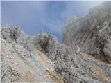 1 1
|
|
|
|
| Janez Seliškar11. 07. 2025 12:15:29 |
Off-trail as off-trail. You walk, search for the easiest passages. Hands useful too.
|
|
|
|
| DVas11. 07. 2025 12:37:31 |
Thanks again
The picture is probably from the Suhadolnik direction?
|
|
|
You must log in to post a comment:
If you do not yet have a username, you must first
register.