|
| miki_29. 06. 2013 20:19:08 |
Does anyone maybe know max. how big a bus can get to the saddle?
Thanks
|
|
|
|
| IgorZlodej9. 06. 2013 20:29:57 |
This year probably none, because they say they won't clear that rockfall and the road will be closed.
 1 1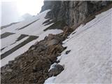 2 2
|
|
|
|
| Manar11. 06. 2013 09:32:58 |
I'm wondering if the path is rideable by bike to the end of the road at the saddle? Thanks for the answer.
| (+2) |  | |
|
|
|
|
| IgorZlodej11. 06. 2013 13:56:31 |
Above you have two pics, where it's more than obvious that the road is snowy.
|
|
|
|
| ljubitelj gora11. 06. 2013 14:09:39 |
and that's the only road, probably he meant if there's another one.
| (+3) | | |
|
|
|
|
| x5x11. 06. 2013 17:23:10 |
You'll be able to get to the hut soon (excavator that's digging is about 50 before the turnoff). For further, I don't know.
|
|
|
|
| matjaz117. 06. 2013 11:37:17 |
In wonderful weather (later light mists rose, but they didn't disturb too much) we carried out yesterday presumably the final tour, but due to wonderful conditions we unanimously decided that this is not yet. The road is not officially open yet (and the question is when it will be due to rockfall on the long traverse under Mangart summit massif), we drove to the excavator pit at the beginning of the mentioned traverse or smaller parking lot. We ascended and skied the Italian path with twice some tens and over cables good fifty meters of ski carrying. Due to great conditions we couldn't resist also the Slovenian gully, which we skied screaming with joy. We join Igor’s tour assessment. Stane, Matjaž and Tomaž P.S. Digging in Rabeljsko Lake was already pure excess...
| (+7) | | |
|
|
|
|
| mdj5. 07. 2013 17:05:52 |
I'm interested if it's possible to get to Mangart from Tamar; I noticed some markers last year,... but I haven't seen route description up here
|
|
|
|
| IgorZlodej5. 07. 2013 17:32:57 |
@mdj I suggest buying the Western Julian Alps mountaineering map and printed guidebook, don't rely on various forums, because that's the last thing that can help you. The same goes for all others who think they'll get everything here.
|
|
|
|
| mdj5. 07. 2013 17:33:04 |
Super, thanks. Regarding the length, no problem... thanks, Igor.
|
|
|
|
| IgorZlodej6. 07. 2013 20:35:39 |
Today Mangart was quite crowded, but few reached the top. I went by "Slovenian" and met many returning, mostly Czechs, Italian family with two kids about 10-12 years and group of very well-equipped Austrians who unfortunately had no ice axes and crampons. Reason was snow, still plenty in the gully and above "shoulder". Descended by "Italian" where of course north side still has snowfields, many turned back there too, which is right, summit will wait.
| (+15) | | |
|
|
|
|
| dprapr6. 07. 2013 21:46:01 |
Such high mountain road leading high under Mangart has good and bad sides!
Irresponsibility of those exposing children to mortal danger, even perhaps despite ignorance, is not excusable.
| (+1) | | |
|
|
|
|
| Laščan14. 07. 2013 10:12:03 |
I'm wondering if it's possible to predict snow conditions on the ascent to Mangart in 10 days?
|
|
|
|
| Laščan14. 07. 2013 17:48:44 |
I'm renewing the question?
Thanks!
|
|
|
|
| urbancek14. 07. 2013 17:54:51 |
Well, you have the post above (6. 7.)... From that it seems to me you can predict how it will be... I don't think it will be much different imo... Regards!
| (+1) | | |
|
|
|
|
| simon00715. 07. 2013 11:43:47 |
Hi! I'm wondering if it's already possible to drive to Mangart saddle by car.
|
|
|
|
| Jana2415. 07. 2013 15:41:26 |
Jana24
Yesterday I was on Mangart, namely from Belopeška lakes via Italian ferrata to saddle then Slovenian one. Snow only on two parts on Slovenian but nice to bypass or there are steps. Down I went Italian to saddle then ,,bypass,, to Bivak Nogaro and back to lakes. Very nice tour. Saddle could be seen to hut where quite some cars parked and also motorcycles heard so they somehow got to hut! Lp.
| (+5) | | |
|
|
|
You must log in to post a comment:
If you do not yet have a username, you must first
register.