|
| andrejp2. 08. 2014 14:43:45 |
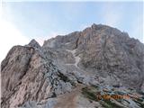
Today on the summit. By car to the saddle or to the parking lot before the landslide. Then to the saddle and descent to bivouac Nogara, then via ferrata back to the saddle. Before the entry to the climbing part there is still 2 m of snow, negligible, protections OK. Then via the Slovenian route to the top. The Slovenian path is quite wet and slippery, no snow on the path - protections OK, except one short cable you almost don't notice is torn. Down the Italian route, still some snow patches, footprints made but still quite dangerous. I put on ,,those small,, crampons and ice axe in hand. Snow can be bypassed also on the lower side, so told me the guys I met on the top.
great fun A
| (+5) |  | |
|
|
|
|
| andrejp2. 08. 2014 19:24:11 |
Thanks, hope tomorrow to visit also Oltar
|
|
|
|
| jetam7. 08. 2014 08:41:32 |
Is the Slovenian path without snow?
|
|
|
|
| jetam7. 08. 2014 13:34:40 |
|
|
|
|
| MANGRT8. 08. 2014 00:01:15 |
Sunset. No peculiarities on the Slovenian one, Italian snowfield still persists 
| (+5) | | |
|
|
|
|
| lakkon8. 08. 2014 16:53:30 |
If the weather is good, it might interest me sometime Wed-Fri next week for the first ascent of Mangart:
Upper Belopeško Lake – Planina Tamar - Nogara bivouac - over Travnik – Slovenian route – Mangart – Italian route (or Slovenian if trouble here) – over Travnik – Nogara – Upper Belopeško Lake
Given that most of the non-climbing part is in Italy where I have little experience, is the route overall well marked?
Will it be possible then maybe fully without crampons and ice axe? Do you recommend given expected conditions rather Slovenian climbing route up and down? What about return via Italian (to junction with Slovenian) and necessity of winter gear?
Self-belay kit mandatory or at least desired?
|
|
|
|
| garmont9. 08. 2014 20:28:06 |
Today on Mangart all alive - mostly foreigners.
Slovenian route OK, on Italian still snowfields which most bypassed below today. Probably due to fog didn't know what's under them.
Regards
| (+5) | | |
|
|
|
|
| Domch9. 08. 2014 22:31:18 |
True pilgrim path today on Mangart. Real mountain tourism especially on Italian route, saw lots inappropriate. Reminded me quite of Triglav. Slovenian route dry above go some minimal on melted snow and at two spots by snowfield a bit wet. In upper part lots scree and rockfall danger. Protections ok, only one less important cable torn in upper part. Italian direction has 4 snowfields. Over first three top to bottom no special issues trampled and wet snow. Last snowfield better bypass below or use ice axe. Definitely caution and proper mountaineering gear still applies.
| (+1) | | |
|
|
|
|
| Domch11. 08. 2014 15:30:36 |
More pics Friday and Saturday.
| (+1) | | |
|
|
|
|
| broken arrow13. 08. 2014 10:36:07 |
Hello! Wondering if the Italian route on Mangart is open without snow?
Thanks
|
|
|
|
| damjan.stros@gmail.com13. 08. 2014 12:41:45 |
Was on Mangart 11.8 via Italian route, still 4 snow fields. Great caution desired
 1 1
| (+2) | | |
|
|
|
|
| broken arrow13. 08. 2014 13:41:22 |
Thanks for the info! Best regards.
|
|
|
|
| lakkon16. 08. 2014 14:53:56 |
Tomorrow maybe first time to Mangart saddle by car. Parking there somewhere and then Slovenian or Italian path to Mangart summit. But since tomorrow is bike ascent to Mangart, organizers say this:
....
Parking will be arranged as always, follow marshals' instructions. - If you have fans, supporters, companions,.. we recommend they use organized bus to the finish. Buses start at 9.30 from Log pod Mangartom and return after event. Road to Mangart saddle closed as soon as all parking up to rockfall filled, which of course not many – around 8.00-8.30. - Follow Police and marshals on route.
....
Can I drive right to Mangart saddle at 2050m and park there? If not, how far and by what time recommend arrival re tomorrow's bike event?
That rockfall mentioned for parking re bike ascent... don't know where it is... does it affect tomorrow's hikers parking?
Oh, and what about parking fee?
Thanks for help.
|
|
|
|
| pohodni16. 08. 2014 17:25:26 |
The rockfall is a bit below the top of the Mangart Saddle. Last year the road there was officially closed to traffic, although many ignored it and parked higher. I don't know how it is this year, probably the same as last year. Below the rockfall there is a small parking lot, further down along the road there is space for some cars. From there to the top of the saddle is about 15 minutes' walk. With the nice weather tomorrow there will surely be a crowd up there. If you get there before 6 a.m., some space will still be available; later it's hard to predict. The parking fee is paid lower in the forest; I don't remember the amount, but it is not excessive.
|
|
|
|
| GregorC16. 08. 2014 17:52:05 |
The road is still officially closed to traffic before the rockfall. Very few drivers obey it. If you are early enough up there, you can park before the rockfall or near the junction for the hut. There is not much space in any case. Maybe consider leaving the car just before the last tunnel.
Expect a big crowd and also heavy traffic on the return when the road opens. There are already many cyclists, tomorrow even more.
|
|
|
|
| ljubitelj gora16. 08. 2014 20:51:18 |
From the Belopeška Lakes there is a nice partly difficult marked path; at the bivouac go right uphill and you arrive a bit above the Mangart Saddle. Parking before Belopeška is never a problem, free and you can see the lakes on the way.
|
|
|
|
| lakkon18. 08. 2014 10:54:11 |
pohodni and gregorC,
yesterday arrived without payment, queues or car issues all the way to the top of the Mangart Saddle, where we parked nicely on the flat... around 7:30... and there was plenty of parking space everywhere... so it seems it's not so bad... since this is a forum about conditions, we could hold a course on handling winter gear on the Italian path... really ideal conditions in the morning, forenoon, when it is still really icy, as shown in this picture.
 1 1
|
|
|
You must log in to post a comment:
If you do not yet have a username, you must first
register.