|
| Bandzo20. 07. 2014 08:49:27 |
With the group we decided to go explore unmarked paths in Karavanks. We chose Palec and Zelenjak. From Ljubelj to Zelenica, where we refilled water a bit, then continued towards Vrtača. At the cairn where the path branches right, I'd warn that a few steps after this junction there's another split. Right the path descends a few meters and then enters scree slopes, which we follow all the way to Žleb. I recommend this path for descent, as going up is a bit tiring. We however went straight at the junction, where bushes were caressing our faces on the lower path. At the beginning some jungle, but higher it disappears and we step on wonderful meadows. From here bushes are recently cleared, so the path ahead is quite pleasant. I look and look and ponder what the path reminds me of. Maybe the path to Jezersko saddle via Mrzli dol (Sleeping valley). No! Even better it reminds me of the path to Prehodavci, where like there Kanjavec, here Zelenjak presents itself. The path is really positive and wonderful. Walk through flowering grove. When we reach Žleb we put on helmets and head right towards Palec. The path is well traceable, but need to be careful not to dislodge scree on those behind. When the path turns into a small "gully" look more carefully where the path goes, so not to go straight up. When we reach the summit we're all happy. Views are wonderful, and quite a few people gathered on top. Carefully descend back to Vrtača and this time continue the path to Zelenjak. The path here is harder to follow, however you reach the summit, probably on return you won't go the same way, as from the top view it's better seen where you can descend easier. Caution is not superfluous. Return we did via the upper path, where we could also "ski on scree" a bit and thus spend excess energy. This less visited part is truly a paradise!
Best regards,
Ben
 1 1") 2 2 3 3 4 4 5 5") 6 6 7 7 8 8 9 9 10 10 11 11 12 12
| (+3) |  | |
|
|
|
|
| Majdag14. 10. 2014 14:18:35 |
... Interesting, very interesting...according to the map right is Zelenjak and next to Vrtača Palec. All descriptions are exactly opposite. And what's correct?
| (+3) | | |
|
|
|
|
| klm14. 10. 2014 14:31:13 |
Correct is looking east of Vrtača: Zelenjak and then Palec. Competent map is Stol and Begunjščica, 1:25.000 PZS, 1986. Otherwise in Stanko Klinar guide section 542 for Zelenjak and 544 for Palec, and in Klemen Jansa guide section 509 to Zelenjak and 512 for Palec.
| (+2) | | |
|
|
|
|
| Majdag14. 10. 2014 14:40:49 |
.. Ah so, thanks
|
|
|
|
| janez.novak14. 10. 2014 17:19:18 |
tinky - one question: do you know where the path to Palec (Zelenjak) branches off the path to Vrtača, the one through bushes. That bush seems very impassable to me, and I'm also afraid of getting lost in it, so I'm interested how to reach the path that (from below) runs on the right side along the scree?
|
|
|
|
| JusAvgustin14. 10. 2014 17:54:17 |
There's a cut path through the dwarf pines! The path that leads along the right side of the cirque is most easily accessible from the middle of the cirque. Regards
|
|
|
|
| tinky14. 10. 2014 18:46:54 |
Janez, the junction is the same. Just a few meters into the forest then right towards the scree. Still recommend going up through the bushes. As Jus already said, the path is cut and you won't get lost.
|
|
|
|
| janez.novak14. 10. 2014 23:11:06 |
How nice it is - I post a question and always get at least one answer. I think the primary purpose of the forum is information exchange, since everyone knows something - happy is the one who gets the info, and also the one who gave it has a pleasant feeling of usefulness.
| (+5) | | |
|
|
|
|
| janez.novak6. 05. 2015 17:49:07 |
tinky - did you go up through the bushes, where down. Thanks for the answer.
|
|
|
|
| tinky6. 05. 2015 19:26:21 |
Yes, we went up through the bushes, down via the scree. The beginning is quite overgrown, higher up it's cut.
|
|
|
|
| aditaker3. 06. 2015 10:40:54 |
Hello!
I would ask if there is any easy marked path to Zelenjak, because I have fear of cliffs and vertigo and I'm looking if there is any easy path to the top, because I need the mountain stamp from Zelenjak?
|
|
|
|
| Skovik3. 06. 2015 10:47:58 |
@Aditaker - as far as I know there is definitely no easy path to the top of Zelenjak. Only difficult, maybe even very difficult pathless terrain. The stamp is right at the cliff.
 1 1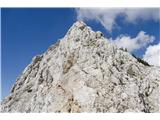 2 2
| (+1) | | |
|
|
|
|
| sebo3063. 06. 2015 22:20:03 |
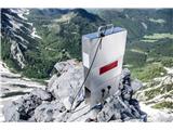
the stamp for Zelenjak is on the first summit when you get up there, so you don't need to go over that ridge. That's definitely the most exposed part. But the path to the first summit is also quite demanding and airy in places
one report from last weekend
sebastjancebular.blogspot.com
|
|
|
|
| heinz3. 06. 2015 23:23:31 |
demanding pathless terrain with less demanding orientation..
|
|
|
|
| dragon29. 06. 2015 21:59:11 |
Yesterday I was on these two beautiful peaks above the beautiful little valley Suho ruševje. I pondered a bit about these names. Thumb is also called Zelenica (which is also written on the cross), Zelenjak is German Peak. I don't know which names are more correct, but if they've been together up there all their lives (like two old spouses), it would be nice if they were called Zelenica and Zelenjak
| (+1) | | |
|
|
|
|
| zlatica30. 06. 2015 05:09:26 |
dragon, good idea.
|
|
|
You must log in to post a comment:
If you do not yet have a username, you must first
register.