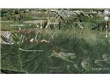
 | Zali Log - Blegoš (via Črni Kal)
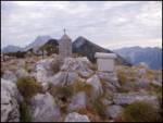
Blegoš is a 1,562-metre-high mountain located between the Selška Sora and Poljanska Sora rivers. From the grassy summit, where there is a stamp a...
3 h 30 min |
 | Rosenbach - Kahlkogel/Golica (via Medji dol)
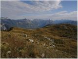
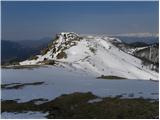
Golica is an unvegetated peak located north of Jesenice. From the summit, where a registration box is placed, there is a fine view of the western...
3 h 45 min |
| Rosenbach - Kahlkogel/Golica (via Quadiaalm)
Golica is an unvegetated peak located north of Jesenice. From the summit, where a registration box is placed, there is a fine view of the western...
3 h 35 min |
| Tallach - Kahlkogel/Golica (via Quadiaalm)
Golica is an unvegetated peak located north of Jesenice. From the summit, where a registration box is placed, there is a fine view of the western...
3 h 50 min |
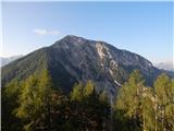
 | Povlje - Bašeljski vrh
Bašeljski vrh is a 1744-meter-high mountain located between Mali Grintovec and Storžič. From the summit, where there is a bench and a registratio...
3 h 50 min |
 | Kal-Koritnica - Svinjak
Svinjak is located east of the Bovec Basin. Despite its relatively low elevation, the summit offers a very beautiful view of the mountains above ...
3 h 15 min |
 | Gostišče Firšt - Govca (Olševa)
Govca is the highest peak of the Olševa range, rising above Koprivna, Solčava, and Remšenik (Remšenik/Remschenig is a valley on the Austrian side...
3 h 45 min |
 | Breginj - Stol (Julian Alps)
Stol (1673 m) is located in the longest ridge of the Julian Alps. The ridge measures 25 km, or 35 km if including the western part. From the summ...
3 h 10 min |
 | Breginj - Muzec - Musc (Mali Muzec)
Muzec or Musc (also Mali Muzec on maps) is a 1,612 m high mountain located north of Breginjski kot. From the summit, where there is a logbook box...
2 h 55 min |
 | Crni Lug - Veliki Risnjak (Horvatova staza)
Veliki Risnjak, at 1528 m, is the highest peak of Risnjak National Park. From the summit, which has a logbook box and stamp, there is a very nice...
3 h 30 min |
 | Žekovec - Boskovec (via Požganija)
Boskovec is with 1587 m the highest peak of the Golte plateau. From the top on which a lookout tower stands, a view opens up on part of Kamnik Sa...
3 h 15 min |
 | Jesenovec - Gladki vrh (Ratitovec) (via Razor)
Gladki vrh (Ratitovec), at 1,667 meters, is the most visited peak in the Ratitovec range. From its bare summit, which features a panorama board, ...
3 h 5 min |
 | Breginj - Gabrovec (Veliki Muzec)
Gabrovec (also Veliki Muzec on maps) is a 1630-meter-high mountain located northwest of Breginj, Slovenia's westernmost village. From the summit,...
3 h |
 | Breginj - Nizki vrh
Nizki vrh is located at the crossroads between Breški Jalovec / Monte Maggiore (ITA) and Gabrovec near the state border; from the summit a beauti...
3 h |
 | Borovlje / Ferlach - Borovski vrh (Žehtar) / Sechter (Raketensteig)
Borovski vrh (Žehtar) / Sechter is a 1,449-meter-high peak located between Grlovec / Ferlacher Horn and Borovlje / Ferlach. From the summit, wher...
2 h 55 min |
| Bajdiše / Waidisch - Borovski vrh (Žehtar) / Sechter
Borovski vrh (Žehtar) / Sechter is a 1,449-meter-high peak located between Grlovec / Ferlacher Horn and Borovlje / Ferlach. From the summit, wher...
3 h |