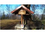
 | Podsreda - Stara sveta gora (Way of the cross)
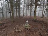
Stara sveta gora, or locally "Stare gore nad Podsredo", is a hill northeast of Podsreda on the southern slopes of the hills separating the valley...
25 min |
 | Podsreda - Stara sveta gora (by Stations of the Cross)
Stara sveta gora, or locally "Stare gore nad Podsredo", is a hill northeast of Podsreda on the southern slopes of the hills separating the valley...
25 min |
| Podsreda - Stara sveta gora (by road)
Stara sveta gora, or locally "Stare gore nad Podsredo", is a hill northeast of Podsreda on the southern slopes of the hills separating the valley...
30 min |
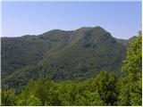
 | Sotina - Sotinski breg (Kugla) (via Patrov Breg)
Sotinski breg (Kugla) is the highest peak of Prekmurje at 418 m. From the summit, which features a wooden observation tower with a bell and cross...
30 min |
 | border crossing Sotina - Sotinski breg (Kugla) (western path)
Sotinski breg (Kugla) is the highest peak of Prekmurje at 418 m. From the summit, which features a wooden observation tower with a bell and cross...
30 min |
 | SSK Sam Ihan - Veliki vrh (Križentaver)
Veliki vrh (Križentaver) is a 419-meter-high hill located above Ihan. The summit features a logbook box with book and a few benches, but offers n...
20 min |
 | Tolmin - Kozlov rob (Grajska pot)
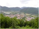
Kozlov rob, or Grad as the locals call it, is a 426-meter-high hill located above Tolmin. From the summit, which features renovated ruins of the ...
30 min |
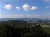
 | Ljubljana (Rakovnik) - Luknje
Luknje is a 438-meter-high peak in the northwestern part of Golovec. At the summit, where the forest educational point Planetarij is located, mod...
30 min |
 | Ljubljana (London) - Črni hrib (Golovec)
Črni hrib is a 440 m high hill in the central part of Golovec. The summit, which has a NOB monument and a bench with a table, is crossed by the T...
30 min |
 | Ljubljana (Bokalce) - Klobuk at Ljubljana
Klobuk is a 441-meter-high peak located west of Ljubljana, more precisely above Stranska vas at Dobrova. From the top, a nice view opens up on pa...
30 min |
 | Podgrad - Castle Stari grad (Stari Osterberg) (on cart track)
Stari grad, or Stari Osterberg, was first mentioned in the 12th century (less likely as early as 1015), at which time the castle belonged to the ...
30 min |
 | Vojnik - Sveti Tomaž above Vojnik (direct way)
Sv. Tomaž is a church on a partly vegetated 444 m high summit near Vojnik. There is a logbook with a stamp at the top. Below the summit stands th...
30 min |
 | Dragomer (bajer) - Strmec (above Dragomer) (past Ferjanka)
Strmec is a distinct, forest-covered peak situated between Dragomer and Log. Numerous logging trails lead to the top. It is located south of the ...
30 min |
 | Dragomer (OŠ Log-Dragomer) - Strmec (above Dragomer)
Strmec is a distinct, forest-covered peak situated between Dragomer and Log. Numerous logging trails lead to the top. It is located south of the ...
30 min |
 | Preval Poljance - Mengore (steep path)
Mengore (453 m) rises between Most na Soči, Volče, and Tolmin. From the summit, where the Church of St. Mary stands alongside the St. Joseph's sh...
30 min |
 | Lake Gradišče - Gradiški grič (by road)
Gradiški grič is situated above the settlement Gradišče pri Lukovici and Gradiško jezero. From the top, below which the church of St. Magdalene s...
20 min |
 | Valburga - Smledniški hrib (Stari grad) (via Kalvarija)
Stari grad (also known as Smlednik Castle) is located on a small hill southwest of Valburga. In recent years, the castle has been renovated and n...
20 min |