 | Pusztaszentlászló - Hahót hegy
Hahót hegy is the second highest peak of the Zala Hills / Zalai dombság. The summit is covered in forest and offers no views....
45 min |
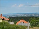
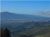
 | Žerovinci (Dom krajanov in gasilcev Žerovinci) - Jeruzalem
Jeruzalem is a 338-meter-high peak located in the center of the namesake village between Ljutomer and Ormož. From the summit, home to the pilgrim...
1 h 15 min |
 | Lake Negova - Cerkvenjak
Cerkvenjak is a settlement in the Slovenske gorice and a point on the Pomurje mountain trail. At the highest point of the settlement, on a 341-me...
1 h |
 | Lovrenc na Dravskem polju - Ptujska Gora
Ptujska Gora is a settlement located on a scenic hill south of the Drava Plain. At the top is the parish church of St. Mary, the Ptujska Gora Mot...
1 h 15 min |
 | Juršinci - Gomila
Gomila is a 352-meter-high peak in the Slovenske gorice, located between Ptuj and Ljutomer. From the summit, which features an 18-meter-high obse...
1 h 15 min |
 | Gočova - Zavrh v Slovenskih goricah
Zavrh is a village in the Slovenske gorice, known to hikers primarily as a checkpoint on the extended Slovenian mountain trail. In the center of ...
1 h 10 min |
 | Stepani - Tinjan
Tinjan is a hilltop village located between Dekani, Zgornje Škofije and Osp. From the summit, the penultimate point of the SPP, there is a nice v...
50 min |
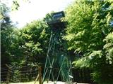 | Gornji Senik / Felsőszölnök - Guard tower above Eisenberg
The guard tower above Eisenberg is located on the border with Hungary. Near the tower is also an Iron Curtain monument....
55 min |
 | Gornji Četar / Felsőcsatár - Nagyvilágos mérőtorony (path by river Pinka)
Nagyvilágos mérőtorony is a former geodetic tower now converted into a lookout tower. It stands atop Četarski breg in western Vas County (Železna...
45 min |
 | Ročinj - Sveti Pavel (above Ročinj) (via Sedlo)
The Church of St. Pavel extends west of the village of Ročinj on a hill at 403 meters elevation. It was built in Gothic style in the late Middle ...
45 min |
 | border crossing Kramarovci - Sveta Ana pri Igu / Sankt Anna am Aigen
Sveta Ana pri Igu / Sankt Anna am Aigen is a settlement near the border with Slovenia where a church of St. Anne more than 300 years old stands. ...
1 h |
 | Zgornji Dražen Vrh - Marija Snežna (Zgornja Velka)
The parish church of Our Lady of the Snows is situated on top of a hill in the settlement Zgornja Velka. Next to the church there are also the Ok...
45 min |
 | Krog - Sveti Kvirik
The church or chapel of St. Kvirik (also listed on maps and elsewhere as St. Kirk, Kirik, Kvirk, Kvirin, or Kirin) stands on a panoramic rise bet...
1 h 15 min |
 | Doklece - Janški vrh (by road)
Janški vrh is a 417-meter-high peak on which stands a small namesake settlement and the Church of St. John the Baptist from the 15th century. The...
45 min |
 | Dolena (Stojana vas) - Janški vrh
Janški vrh is a 417-meter-high peak on which stands a small namesake settlement and the Church of St. John the Baptist from the 15th century. The...
50 min |
 | border crossing Sotina - Sotinski breg (Kugla)
Sotinski breg (Kugla) is the highest peak of Prekmurje at 418 m. From the summit, which features a wooden observation tower with a bell and cross...
45 min |
 | Sotina - Sotinski breg (Kugla) (via the source of mineral water)
Sotinski breg (Kugla) is the highest peak of Prekmurje at 418 m. From the summit, which features a wooden observation tower with a bell and cross...
50 min |
 | Pernica - Vavtošek
Vavtošek is a scenic summit in the Slovenske Gorice on which several transmitters stand. From the top there is a fine view mainly towards the sou...
1 h 5 min |
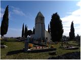
 | Laško (cemetery Laško) - Church of St. Michael at Šmihel (past Sveti Krištof)
The Church of St. Michael at Šmihel is situated on a scenic hill above Laško. From the church, beautiful views open up to Veliko Kozje, Kopitnik,...
52 min |
 | Podgrad - Castle Stari grad (Stari Osterberg) (on Ostrovrhar trail)
Stari grad, or Stari Osterberg, was first mentioned in the 12th century (less likely as early as 1015), at which time the castle belonged to the ...
45 min |
 | Vojnik - Sveti Tomaž above Vojnik
Sv. Tomaž is a church on a partly vegetated 444 m high summit near Vojnik. There is a logbook with a stamp at the top. Below the summit stands th...
1 h |
 | Ljubljana (Gruberjeva brv) - Mazovnik (Golovec)
Mazovnik, at 450 m, is the highest peak of Golovec, a hill range located on the southeastern outskirts of Ljubljana. Golovec remained bare until ...
1 h |
 | Kubed - Lačna
Lačna is a 451-meter-high hill located between Gračišče, Kubed, and Hrastovlje. The summit, which features a metal observation tower offering nic...
45 min |
 | Ljubljana (Žabja vas) - Orle
Orle is a settlement in the Municipality of Škofljica, located on a small hill northeast of the Ljubljana Marshes. A few meters below the highest...
1 h 15 min |
 | Stainz bei Straden - Rosenberg
Rosenberg is a panoramic peak located south of the Aussichtswarte Vulkanland observation tower, or just slightly above the settlement of Rožni Vr...
1 h 10 min |