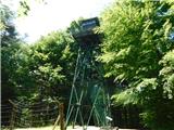
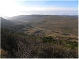
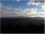
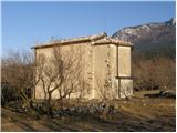
 | Gornji Senik / Felsőszölnök - Guard tower above Eisenberg
The guard tower above Eisenberg is located on the border with Hungary. Near the tower is also an Iron Curtain monument....
55 min |
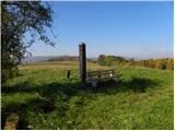
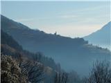
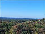 | Gornji Četar / Felsőcsatár - Nagyvilágos mérőtorony (path by river Pinka)
Nagyvilágos mérőtorony is a former geodetic tower now converted into a lookout tower. It stands atop Četarski breg in western Vas County (Železna...
45 min |
 | Gornji Četar / Felsőcsatár - Nagyvilágos mérőtorony (pot zeleni trikotnik)
Nagyvilágos mérőtorony is a former geodetic tower now converted into a lookout tower. It stands atop Četarski breg in western Vas County (Železna...
35 min |
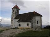
 | Ročinj - Sveti Pavel (above Ročinj) (via Sedlo)
The Church of St. Pavel extends west of the village of Ročinj on a hill at 403 meters elevation. It was built in Gothic style in the late Middle ...
45 min |
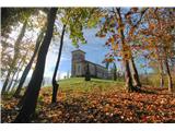 | Ročinj - Sveti Pavel (above Ročinj) (via Preval)
The Church of St. Pavel extends west of the village of Ročinj on a hill at 403 meters elevation. It was built in Gothic style in the late Middle ...
40 min |
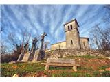 | Ročinj - Sveti Pavel (above Ročinj) (past sacred signs)
The Church of St. Pavel extends west of the village of Ročinj on a hill at 403 meters elevation. It was built in Gothic style in the late Middle ...
35 min |
 | Gorenja Žaga - Kostel Castle
Kostel Castle sits on a panoramic hill above the left bank of the Kolpa River. From the castle, which together with its associated settlement for...
35 min |
 | Zgornji Dražen Vrh - Marija Snežna (Zgornja Velka)
The parish church of Our Lady of the Snows is situated on top of a hill in the settlement Zgornja Velka. Next to the church there are also the Ok...
45 min |
 | Komare doline - Vrh križa
Vrh križa is a 411-meter-high hill located north of the village of Smokvica. From the top, a nice view opens up onto Istria, the Gulf of Trieste,...
40 min |
 | Serdica - Serdiški breg (Rdeči breg)
Serdiški breg (Rdeči breg) is a 416 m high hill located right next to the Austrian border. From its grassy summit, which has a few benches and a ...
40 min |
 | border crossing Sotina - Serdiški breg (Rdeči breg)
Serdiški breg (Rdeči breg) is a 416 m high hill located right next to the Austrian border. From its grassy summit, which has a few benches and a ...
35 min |
 | Nuskova - Serdiški breg (Rdeči breg)
Serdiški breg (Rdeči breg) is a 416 m high hill located right next to the Austrian border. From its grassy summit, which has a few benches and a ...
50 min |
| Sotina (Dajčev mlin) - Serdiški breg (Rdeči breg)
Serdiški breg (Rdeči breg) is a 416 m high hill located right next to the Austrian border. From its grassy summit, which has a few benches and a ...
35 min |
| Serdica - Serdiški breg (Rdeči breg) (via Brunarjev breg)
Serdiški breg (Rdeči breg) is a 416 m high hill located right next to the Austrian border. From its grassy summit, which has a few benches and a ...
50 min |
 | Doklece - Janški vrh (by road)
Janški vrh is a 417-meter-high peak on which stands a small namesake settlement and the Church of St. John the Baptist from the 15th century. The...
45 min |
 | Dolena (Stojana vas) - Janški vrh
Janški vrh is a 417-meter-high peak on which stands a small namesake settlement and the Church of St. John the Baptist from the 15th century. The...
50 min |
 | Sotina - Sotinski breg (Kugla) (by road)
Sotinski breg (Kugla) is the highest peak of Prekmurje at 418 m. From the summit, which features a wooden observation tower with a bell and cross...
35 min |
 | border crossing Sotina - Sotinski breg (Kugla)
Sotinski breg (Kugla) is the highest peak of Prekmurje at 418 m. From the summit, which features a wooden observation tower with a bell and cross...
45 min |
 | Sotina - Sotinski breg (Kugla) (via the source of mineral water)
Sotinski breg (Kugla) is the highest peak of Prekmurje at 418 m. From the summit, which features a wooden observation tower with a bell and cross...
50 min |
 | TV Neuhaus am Klausenbach - Sotinski breg (Kugla)
Sotinski breg (Kugla) is the highest peak of Prekmurje at 418 m. From the summit, which features a wooden observation tower with a bell and cross...
35 min |
 | Svečina - Čajžič
Čajžič is a smaller hill located northwest of Zgornja Kungota. Its summit, a popular hiking spot for local residents, has a bench and a logbook b...
40 min |
 | Rožna dolina - Šišenski hrib (Rožnik) (via Cankarjev vrh)
Šišenski hrib, at 429 m, is the highest peak of Rožnik, the hill that rises above the centre of Ljubljana. From the summit, where several transmi...
40 min |
 | Donja Višnjica - Vidikovac Tri Žaklji
Tri Žaklji is a viewpoint at 430 meters above sea level. It is located 1.4 km east-southeast of Donja Višnjica and 2 km north to northwest of Gor...
35 min |
 | Topole - Mengeška koča on Gobavica
Gobavica is a hill rising above Mengeš. Mengeška koča mountain hut stands on it, along with a goat pen. It is one of the starting points for the ...
45 min |
 | Gorica pri Slivnici - Gradišče (above Slivniško jezero) (eastern path)
Gradišče above Slivniško Lake lies between the settlements of Gorica pri Slivnici and Tratna pri Grobelnem. From the logbook box on Gradišče, a f...
35 min |
 | Laško (cemetery Laško) - Church of St. Michael at Šmihel
The Church of St. Michael at Šmihel is situated on a scenic hill above Laško. From the church, beautiful views open up to Veliko Kozje, Kopitnik,...
40 min |
| Laško (cemetery Laško) - Church of St. Michael at Šmihel (past Sveti Krištof)
The Church of St. Michael at Šmihel is situated on a scenic hill above Laško. From the church, beautiful views open up to Veliko Kozje, Kopitnik,...
52 min |
 | Polzela - Vinski vrh (Vimperk)
Vinski vrh, or Vimperk, is a hill located north of Polzela. The summit is crowned by the Church of St. Nicholas, next to which stands a small hou...
40 min |
 | Kubed - Lačna
Lačna is a 451-meter-high hill located between Gračišče, Kubed, and Hrastovlje. The summit, which features a metal observation tower offering nic...
45 min |
 | Komare doline - Lačna
Lačna is a 451-meter-high hill located between Gračišče, Kubed, and Hrastovlje. The summit, which features a metal observation tower offering nic...
35 min |
 | Straža - Želin - Sveti Pavel (Straža)
The Church of St. Paul is situated above the settlement of Straža, specifically between the Cerknica and Zaganjalščica streams. From the church, ...
35 min |
 | Stoperce - Sveta Ana above Stoperce
The Church of St. Anne is situated on a 460-meter-high hill rising west of the settlement Stoperce. From the church or its nearby surroundings, a...
40 min |
 | Pichla bei Radkersburg - Königsberg
Königsberg is a 462-meter-high peak situated in Steiermark near the border with Slovenia. On the summit of volcanic origin, there are some memori...
40 min |
 | Suhadole - Koseški hrib (via Mlinčki)
Koseški hrib is located between Kuharjev boršt and Koseze, the settlement after which the peak is also named. From the summit, which has a table,...
50 min |
| Bukovica pri Vodicah - Koseški hrib (via Mlinčki)
Koseški hrib is located between Kuharjev boršt and Koseze, the settlement after which the peak is also named. From the summit, which has a table,...
50 min |
 | Topole - Koseški hrib
Koseški hrib is located between Kuharjev boršt and Koseze, the settlement after which the peak is also named. From the summit, which has a table,...
55 min |
 | Dragomer - Strmca (via Ferjanka)
Strmca is a lesser-known forested hill located between the settlements of Brezje pri Dobrovi and Log pri Brezovici. Due to the forest cover, ther...
45 min |
 | Jezero - Sveta Ana
The Church of St. Ana is situated on a small panoramic hill above Jezero, Podpeč, and Preserje. From the top, which has a panorama board, a nice ...
35 min |
 | Bevško - Špicberg
Špicberg, or Ostri Vrh, is a ridge directly above Trbovlje. The ridge consists of several indistinct peaks; the highest is 490 m high, with a car...
35 min |
 | Bad Gleichenberg (Eichgraben Weg) - Mühlsteinbruch
Mühlsteinbruch lies north to northeast of Bad Gleichenberg. A cross stands on the summit, with the Edelweißwarte lookout tower and Enzian Hütte h...
35 min |
 | Brezje pri Dobrovi - Vrhovčev grič (via Strmca)
Vrhovčev grič is an indistinct, forested peak located just a few meters off the marked trail between Debeli hrib and Strmca....
50 min |
 | Rechnitz (Badesee) - Donatikappele (above Rechnitz)
The Chapel of St. Donatus is located on a small hill northwest of the settlement Rechnitz....
45 min |
 | Škofja Loka - Divja Loka Castle (Stari grad)
Divja Loka Castle (also known as Stari grad) above Škofja Loka is located on a small hill north of Nemški grič. First mentioned in 1202, it was r...
40 min |
 | Loka pri Žusmu (Žamerk) - Castle Žusem
Castle Žusem (German Sussenheim), of which only ruins remain today, is located east to northeast of Žusem, a peak with a lookout tower....
50 min |
 | Stari trg (Pilštanj) - Vina gora
Vina Gora is a scenic hill rising east of the medieval market town of Pilštanj. Its summit has been converted into an attractive open-air museum ...
45 min |
| Lesično - Vina gora
Vina Gora is a scenic hill rising east of the medieval market town of Pilštanj. Its summit has been converted into an attractive open-air museum ...
45 min |
| Lesično - Vina gora (along the water educational trail)
Vina Gora is a scenic hill rising east of the medieval market town of Pilštanj. Its summit has been converted into an attractive open-air museum ...
45 min |
| Stari trg (Pilštanj) - Vina gora (zahodna pot)
Vina Gora is a scenic hill rising east of the medieval market town of Pilštanj. Its summit has been converted into an attractive open-air museum ...
55 min |
| Lesično - Vina gora (zahodna pot)
Vina Gora is a scenic hill rising east of the medieval market town of Pilštanj. Its summit has been converted into an attractive open-air museum ...
55 min |
| Lesično - Vina gora (along the water educational trail and along the western path)
Vina Gora is a scenic hill rising east of the medieval market town of Pilštanj. Its summit has been converted into an attractive open-air museum ...
55 min |
 | Vrtovin - Školj Svetega Pavla above Vrtovin
Školj sv. Pavla is located on a panoramic hill above the village of Vrtovin, which lies west of Ajdovščina. From the church, near which the logbo...
35 min |
 | Pirman - Turjak Castle (longer path)
Turjak Castle (Slovenian: Grad Turjak or Turjaški grad; German: Burg Ursperg, later Schloss Auersperg) lies on the edge of Turjak village and is ...
40 min |
 | Spodnje Radvanje - Archaeological site Poštela
The archaeological site Poštela is located on a forested hill in the far eastern part of Pohorje....
40 min |
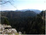
 | Prevala - Veliki hrib (survey point 526)
Veliki hrib, or kota 526 (the latter mainly associated with World War I; also Mali vrh on some maps), is a peak located northwest of Škabrijel, w...
35 min |
 | Dravograd lake - Church of the Holy Cross at Dravograd
The Church of the Holy Cross near Dravograd stands on a panoramic rise from which fine views extend over the western Pohorje, Slovenjgraška Basin...
45 min |
 | Tourist farm Žurej - Church of St. Helena on Javor
The Church of St. Helena stands on Javor, just off the highest point of the nearby peak where there is also a summit register box and an NOB monu...
45 min |
 | Ljubljana (G Design Hotel) - Gradišče (above Dobrova)
Gradišče is a forest-covered peak located south of the settlement Dobrova and north of Brezovica pri Ljubljani. From the summit, where there is a...
45 min |