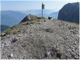
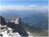
 | Lienzer Dolomitenhütte - Große Sandspitze (Panorama Kletterweg)
Große Sandspitze, at 2772 meters, is the highest peak of the Lienz Dolomites. From the summit, which has a summit register box, a breathtaking vi...
5 h |
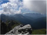
 | Lienzer Dolomitenhütte - Daumen
Daumen is a 2720-meter-high peak situated in the heart of the Lienz Dolomites. From its summit, which is indistinct from afar, a nice view opens ...
4 h 30 min |
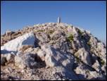
 | Klammbrückl - Große Gamswiesenspitze (Madonnen Klettersteig)
Große Gamswiesenspitze is a 2,488-meter-high mountain located in the heart of the Lienz Dolomites. From the summit, which features a summit logbo...
5 h |
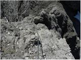
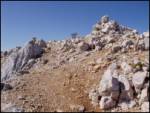
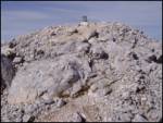
 | Piano Fiscalino / Fischleinboden - Torre di Toblin / Toblinger Knoten
Torre di Toblin is a 2,617-meter peak in the Sexten Dolomites Nature Park. This challenging summit is accessed via an interesting via ferrata, of...
4 h 30 min |
 | Parking Erichhütte - Hoher Kopf (Königsjodler)
Hoher Kopf is located in the Berchtesgaden Alps, west of the highest peak, Höchkonig. The summit is popular mainly due to the protected climbing ...
7 h |
 | Palafavera - Monte Civetta (Via Ferrata Alleghesi)
Monte Civetta is one of the main mountains in the Dolomites. It is recognizable primarily by its more than 1000-meter-high northwestern wall. Thi...
6 h 30 min |
 | Erschbaum - Große Kinigat / Monte Cavallino (Klettersteig)
Große Kinigat / Monte Cavallino is a 2,689-meter peak in the Carnic Alps. Located in the western part, it is one of the few there made of limesto...
4 h 30 min |
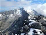 | Dösner Alm - Säuleck (Klettersteig)
Säuleck is a 3,086-meter peak in the High Tauern. The summit features a cross and summit register box, providing nice views of nearby peaks such ...
6 h 30 min |
| Landro - Torre di Toblin / Toblinger Knoten
Torre di Toblin is a 2,617-meter peak in the Sexten Dolomites Nature Park. This challenging summit is accessed via an interesting via ferrata, of...
4 h 30 min |
 | Ravenska Kočna - Grintovec (on ferrata and Frischaufova pot)
Grintovec is the highest peak of the Kamnik-Savinja Alps. It is located above the Kamniška Bistrica Valley, Suhi Dol, and the Ravenska Kočna Vall...
5 h 45 min |
 | Ravenska Kočna - Grintovec (on ferrata and Kremžarjeva pot)
Grintovec is the highest peak of the Kamnik-Savinja Alps. It is located above the Kamniška Bistrica Valley, Suhi Dol, and the Ravenska Kočna Vall...
5 h 45 min |
 | Ravenska Kočna - Jezerska Kočna (on ferrata and Frischaufova pot)
Jezerska Kočna is located west of Grintovec. From the summit, there is a very nice view towards Grintovec. The Karawanks and the Gorenjska plain ...
7 h |
| Ravenska Kočna - Jezerska Kočna (on ferrata and Kremžarjeva pot)
Jezerska Kočna is located west of Grintovec. From the summit, there is a very nice view towards Grintovec. The Karawanks and the Gorenjska plain ...
5 h 30 min |
 | Ravenska Kočna - Skuta (on ferrata and over Dolgi hrbet)
Skuta is a 2,532-meter-high mountain located in the heart of the Kamnik-Savinja Alps. From the summit, which has a logbook box and a stamp, a bea...
6 h 15 min |
 | Ravenska Kočna - Kokrska Kočna (on ferrata and Kremžarjeva pot)
Kokrska Kočna is a panoramic and spacious mountain between Jezersko and Suhadolnik. From the summit, which has a logbook box, there is a very nic...
6 h |
 | Ravenska Kočna - Dolgi hrbet (on ferrata and on path Frischaufova pot)
Dolgi Hrbet lies between Grintovec and Skuta. From its precipitous summit there is a fine view across the heart of the Kamnik-Savinja Alps. Dolgi...
5 h 30 min |