 Poll: Golica Poll: GolicaThe question in the previous poll was: Have you already been to Golica (1835 m) this year? Golica i...
|
|
|
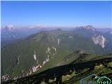
 Mrzla gora Mrzla goraZoran, super tour What about Lintver and why is he forgotten? Maybe hes a dragon?...  Dve Špici-Due Pizzi Dve Špici-Due PizziI drive along the wide asphalt road to 1100m at Plan dei Spadovai and go past the bivouac to Dve špi...
|
|
|
Commented trips
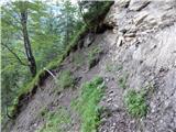 Mlinarica - Goličica Mlinarica - GoličicaWho is supposed to repair them? Whoever likes waiting for these strangers so much (unmarked path), s...
|
|
|
|
|
|
|
New trips
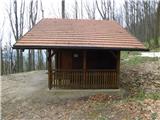 Gorjane (Železno) - Bivak Lovske družine Pišece Gorjane (Železno) - Bivak Lovske družine PišeceBivak Lovske družine Pišece is a small purpose-built shelter with a roof that serves hikers as a refuge and resting place; otherwise, the hut belongs to the hunting association. Benches are arranged a...
|
|
|
|
|
|
|
|
|
|
|
Random trip
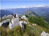 Kal (Krnčica ridge) Kal (Krnčica ridge)Kal is a 1,699-meter-high peak on the western part of the ridge running from Krn through Krnčica toward the Bovška Basin. The peak is known for the battles fought here during World War I. Ruins of an Italian fortification are still visible on the summit. From this summit, which lies on the border of...
|
|
|
|
|
|
|