|
| vandica121. 02. 2012 23:03:31 |
Oh Gita, we met, I was climbing when you were coming back. Yeah, you didn't leave a thumb for the snowman It was pure enjoyment, and I as a treat from the top watched the sunset with an almost dark red sun, too bad the camera stayed home. It was pure enjoyment, and I as a treat from the top watched the sunset with an almost dark red sun, too bad the camera stayed home.
|
|
|
|
| GITA21. 02. 2012 23:19:22 |
Hey @vandica1, yeah we really didn't leave him a thumb ...at least he'll stand up there peacefully for another day ...the sunset was beautiful already from the valley, let alone from the top!!!
Hey, if you meet us somewhere again, tug our sleeve a bit so we say something... you three or four were climbing when we were returning and I really didn't quite remember you to recognize next time...
|
|
|
|
| vandica121. 02. 2012 23:44:56 |
I'll chat a bit next time, since I also only met my husband because of the red jacket, as he kindly moved it from the path for me. I wish you many more such relaxed days.
|
|
|
|
| GITA22. 02. 2012 00:15:32 |
We wish you the same too, and forget the little camera as rarely as possible, and post some picture sometime...
|
|
|
|
| lanževica3. 03. 2012 16:02:45 |
Today I went to cure my cold in Primorska. From Podgorje to Slavnik it was just the right amount of walking, warm and sunny weather, a little windy. The hut is open on Saturdays and Sundays.
I can't believe how much snow has melted in such a short time when I look at Gita's photos...
| (+1) |  | |
|
|
|
|
| Hribovc8825. 10. 2012 22:54:27 |
Today I climbed from Hrpelje to Slavnik, and I wanted to descend towards Prešnica, but I got lost (from Tumova hut onwards, where there are signposts, I didn't spot the sign for Prešnica anymore , so even now it's not clear to me where I should have turned for Prešnica , so even now it's not clear to me where I should have turned for Prešnica , if anyone knows please write, so I'll know for next time), so in the end I reached Povžane. A little before Povžane I met a friendly local with whom we chatted a bit, then I continued towards Hrpelje along the main road Reka-Kozina. In Tublje I decided to hitchhike, soon a policeman stopped for me and took me to Hrpelje. , if anyone knows please write, so I'll know for next time), so in the end I reached Povžane. A little before Povžane I met a friendly local with whom we chatted a bit, then I continued towards Hrpelje along the main road Reka-Kozina. In Tublje I decided to hitchhike, soon a policeman stopped for me and took me to Hrpelje.
Otherwise, today the weather was great for hiking, Indian summer in the true sense, only on the top there was quite a cold wind.
Photographs:
| (+1) | | |
|
|
|
|
| B228. 10. 2012 13:45:50 |
Hribovc88 hello!
From the hut you should have returned the same way (SPP - TZV 1), to the signpost that's in photo 17 and it says Prešnica 1.5 hours. From there, to the next signpost at the junction towards Hrpelje is another 15 minutes walk. There you should go straight ahead and always downhill, cross the forest road and always follow SPP markers. I assume you also walked quite a bit on the road from Hrpelje to Slavnik. The marked path from Hrpelje to Slavnik actually starts at the school and not at the municipality building, where there's a road sign "Slavnik". It's always good to use the appropriate hiking map - in this case "Slovenska Istra, Čičarija, Brkini, Kras". And many nice experiences in the Primorska hills and of course elsewhere...
| (+1) | | |
|
|
|
|
| Hribovc8828. 10. 2012 14:27:19 |
Hello B2,
yes, all the way I walked on the road, namely from the railway station onwards it's very poorly marked, or rather up to the municipality I didn't spot any signs for Slavnik at all, then at the place where it says Slavnik (place sign, not marker) I turned right, then from there onwards again very poorly marked, a bit more concretely marked then at that junction on the 6th or 7th photo.
Thanks for all the notes and tips, now I'll know for next time where to go up to Slavnik and down to Prešnica. So, to sum up: for Prešnica I should have gone back on the road where I came from Hrpelje, then apparently there's a junction for Prešnica somewhere, which I didn't notice. I'm also interested in which path is most suitable for ascent in winter time, are all paths trodden? I'm also wondering if this SPP stamp is correct?
Thanks
|
|
|
|
| B228. 10. 2012 14:40:12 |
Yes the markings start at the school (sign), about 200m further from where you turned towards Slavnik. For Prešnica you should go along the road to the sign that's in photo 17 and then exclusively downhill on the trodden path and follow SPP markers (1). In winter all marked hiking paths are trodden. The most visited are from Podgorje, Prešnica and Skadanščina. I think the stamp will meet the requirements, but it should be oval (hut stamp) with "Slovenska planinska pot" next to the hut name and altitude. Otherwise the Slavnik summit stamp is built into a pillar on the top.
| (+1) | | |
|
|
|
|
| Hribovc8828. 10. 2012 15:02:29 |
Now it's much clearer to me where I should have gone, thanks B2
Otherwise this trip turned out a bit "unsuccessful":
1. Up I could have gone on the marked path, i.e. 200 meters further, from where I turned.
2. I could have returned as planned, towards Prešnica, where I also intended to see a very picturesque village that I always observe from the train.
3. The stamp isn't quite right, and I didn't notice it on the pillar or rather didn't pay special attention, I just assumed they have it only in the hut, which is open only on weekends.
4. Because my camera battery ran out I managed to take only 21 photos.
Proof that one learns something new every day
I hope to repeat the trip soon
|
|
|
|
| B228. 10. 2012 16:06:15 |
Hribovc88, warmly welcome to Primorska, no problem, I too have learned from mistakes many times and didn't always find the set goal the first time. Good luck next time and nice experiences in the hills near the sea...
| (+2) | | |
|
|
|
|
| m28. 10. 2012 17:23:16 |
Hello, Hribovc88 or Blaž!
Our little hills are really nice too,
congratulations on the ascent and nice photos.
For me the nicest ascent to Slavnik is from Prešnica.
Regarding solo ascent to Snežnik, you need to take a longer summer day, now the day is too short for such a long path and too cold and unstable weather, and even then there will be more people on the paths.
Years ago, on a night hike to Slavnik, I met a man around 70 years or more, who every summer spends 1 week on the path from Snežnik towards Javorniki. Sleeps in a sleeping bag outdoors or in huts - Sviščaki, on Mašun. And he said he likes it. Of course he approximately knows the terrain - dangers of chasms and ignores close encounters with beasts
Good luck, M
| (+1) | | |
|
|
|
|
| Hribovc8828. 10. 2012 18:08:45 |
Hi m, you really made me crave it, so I decided to definitely go to Slavnik next time from Prešnica up
Hats off to that gentleman
|
|
|
|
| skalaš7016. 01. 2013 11:50:18 |
Isabel23, this looks very "MAGICAL".
Nice greetings and safe steps.
|
|
|
|
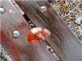
| Jaša31. 01. 2013 19:59:01 |
Today Slavnik was the right stuff...
in Podgorje I found an ORANGE LENS OF SPORTS GLASSES (looks undamaged) and left it on the bench under the linden.
 1 1 2 2
| (+1) | | |
|
|
|
|
| bojan7931. 01. 2013 20:28:06 |
I was there today too, started from Prešnica
| (+2) | | |
|
|
|
|
| 5ro4. 02. 2013 21:21:13 |
After Saturday rains and bora, on Sunday morning I looked towards Slavnik. White to Podgorje! I waited for crappy weather and headed to Slavnik from Podgorje on the steep path. The tour was a real "winter" one, sometimes snow to the knees, the path well trodden. Towards the top, where the bora swept the young snow away, barely a cm left. By the hut it was nice to hang out, on the very top icy and windy.
| (+12) | | |
|
|
|
You must log in to post a comment:
If you do not yet have a username, you must first
register.