 | Lendava (TIC Lendava) - Lookout tower Vinarium Lendava
The Vinarium Lendava lookout tower is situated in the middle of Lendavske gorice. The 53.5-meter-high lookout tower can be ascended via 240 stair...
30 min |
 | Dolga vas - Lookout tower Vinarium Lendava
The Vinarium Lendava lookout tower is situated in the middle of Lendavske gorice. The 53.5-meter-high lookout tower can be ascended via 240 stair...
30 min |
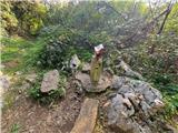 | Duga Resa - Vinica
Vinica is a forested hill in Kordun, east of Duga Resa and south of Karlovac. The summit is rocky and an HPO point. At the top there is a boundar...
30 min |
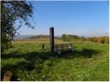
 | Lendava (Tuš Supermarket Kocet) - Piramida (Lendavske gorice)
The Piramida is a stone marker on the highest point of Lendavske gorice, where there is also a logbook box and a stamp of the Pomurje mountain tr...
45 min |
| Lendava (TIC Lendava) - Piramida (Lendavske gorice)
The Piramida is a stone marker on the highest point of Lendavske gorice, where there is also a logbook box and a stamp of the Pomurje mountain tr...
40 min |
| Dolga vas - Piramida (Lendavske gorice)
The Piramida is a stone marker on the highest point of Lendavske gorice, where there is also a logbook box and a stamp of the Pomurje mountain tr...
40 min |
 | Pusztaszentlászló - Hahót hegy
Hahót hegy is the second highest peak of the Zala Hills / Zalai dombság. The summit is covered in forest and offers no views....
45 min |
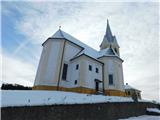
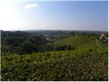 | Miklavž pri Ormožu - Jeruzalem
Jeruzalem is a 338-meter-high peak located in the center of the namesake village between Ljutomer and Ormož. From the summit, home to the pilgrim...
45 min |
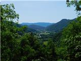
 | Krško - Sveti Primož (Kremen)
The Church of St. Primož is located above the village of Kremen, northeast of Krško. From the church or its immediate surroundings, there is a ni...
25 min |
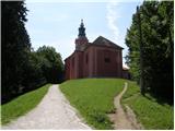
 | Doklece - Ptujska Gora
Ptujska Gora is a settlement located on a scenic hill south of the Drava Plain. At the top is the parish church of St. Mary, the Ptujska Gora Mot...
40 min |
| Stogovci - Ptujska Gora
Ptujska Gora is a settlement located on a scenic hill south of the Drava Plain. At the top is the parish church of St. Mary, the Ptujska Gora Mot...
35 min |
 | Vonarje - Sveta Ema (Emina tematska pot)
Sveta Ema is a mountain, settlement, and church rising between Sotla and Mestinjščica. Marked trails lead to the summit from Rogaška Slatina, Von...
25 min |
 | Sodna vas - Sveta Ema
Sveta Ema is a mountain, settlement, and church rising between Sotla and Mestinjščica. Marked trails lead to the summit from Rogaška Slatina, Von...
30 min |
 | Ladvenjak - Martinščak (težja pot)
Martinščak is a 345-meter hill in the Kordun region, located southeast of Karlovac. At the summit there is the Chapel of Saint Martin, built in 1...
25 min |
| Ladvenjak - Martinščak (lažja pot)
Martinščak is a 345-meter hill in the Kordun region, located southeast of Karlovac. At the summit there is the Chapel of Saint Martin, built in 1...
30 min |
 | Nuskova - Beli breg
Beli breg is a 346-meter-high hill located in Goričko. From its grassy summit, a beautiful view opens up that reaches all the way to the Alps in ...
30 min |
 | Nuskova - Beli breg (via Rožičev breg)
Beli breg is a 346-meter-high hill located in Goričko. From its grassy summit, a beautiful view opens up that reaches all the way to the Alps in ...
45 min |
 | Brod na Muri (Sladki Vrh) - Beli vrh
Beli vrh is a 355-meter-high hill located above the right bank of the Mura River....
30 min |
 | Podčetrtek (Terme Olimia) - Castle Podčetrtek
Castle Podčetrtek, or Windischlandsberg in German, is located on a hill above Podčetrtek along a marked trail leading to Silavec or the Tower of ...
30 min |
 | Zgornja Ščavnica (Mlin Rožman) - Sveta Ana v Slovenskih goricah
Sveta Ana v Slovenskih goricah is a settlement in the Municipality of Sveta Ana. The parish church of St. Ana stands at the highest point of the ...
30 min |
 | Andovci / Orfalu - Katin breg / Katalin-hegy (past border stone A 115)
Katin breg / Katalin-hegy is a small hill located on the Hungarian side of the Čepinci border crossing, near the village of Verica-Ritkarovci / K...
45 min |
 | Trdkova - Bogin breg
Bogin breg is a 371-meter-high hill situated between Dolič and Trdkovo. From the summit, where a transmitter stands, there is no nice view due to...
25 min |
| Kuzma - Bogin breg
Bogin breg is a 371-meter-high hill situated between Dolič and Trdkovo. From the summit, where a transmitter stands, there is no nice view due to...
45 min |
 | Trdkova - Tromejnik / Dreiländerecke / Harmashatar (Ježkova pot - through forest)
Tromejnik, known in German as Dreiländerecke or in Hungarian as Hármashatár, is a 390 m high hill located at the tripoint between Slovenia, Austr...
25 min |
 | Oberdrosen - Tromejnik / Dreiländerecke / Harmashatar
Tromejnik, known in German as Dreiländerecke or in Hungarian as Hármashatár, is a 390 m high hill located at the tripoint between Slovenia, Austr...
30 min |
 | Trdkova - Holzmannkogel (on marked path through the forest)
Holzmannkogel is a 393-meter-high hill located north of Tromejnik. The summit is forested and offers no significant views....
35 min |
| Oberdrosen - Holzmannkogel
Holzmannkogel is a 393-meter-high hill located north of Tromejnik. The summit is forested and offers no significant views....
30 min |
 | Tivoli - Cankarjev vrh (Rožnik) (by road)
Cankarjev vrh is a 394 m high hill located east of Ljubljana Zoo. From the summit, where a church and a restaurant stand, the surrounding forest ...
40 min |
 | Stari trg (Pilštanj) - Na gradu (Grad Pilštanj)
Na gradu is a 403-meter-high peak rising directly above the picturesque medieval market town of Pilštanj in the heart of Kozjansko Park. Modest r...
30 min |
| Lesično - Na gradu (Grad Pilštanj)
Na gradu is a 403-meter-high peak rising directly above the picturesque medieval market town of Pilštanj in the heart of Kozjansko Park. Modest r...
25 min |
| Lesično - Na gradu (Grad Pilštanj) (along the water educational trail)
Na gradu is a 403-meter-high peak rising directly above the picturesque medieval market town of Pilštanj in the heart of Kozjansko Park. Modest r...
25 min |
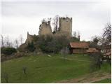
 | Gorenja Žaga - Kostel Castle
Kostel Castle sits on a panoramic hill above the left bank of the Kolpa River. From the castle, which together with its associated settlement for...
35 min |
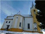
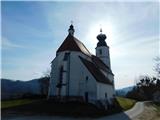
 | Zgornji Dražen Vrh - Marija Snežna (Zgornja Velka)
The parish church of Our Lady of the Snows is situated on top of a hill in the settlement Zgornja Velka. Next to the church there are also the Ok...
45 min |
 | Spodnje Tinsko - Tinska gora
Tinska gora, at an elevation of 409 meters, lies on the ridge separating the valleys of Zibiški potok and Tinski potok streams. Despite its low a...
30 min |
 | Komare doline - Vrh križa
Vrh križa is a 411-meter-high hill located north of the village of Smokvica. From the top, a nice view opens up onto Istria, the Gulf of Trieste,...
40 min |
 | Jama Pekel (parking lot) - Pogorišče (gentle path)
Pogorišče is a forested peak located on the Ponikovski Kras. At the top, or slightly below the highest point of the hill, there is a register box...
25 min |
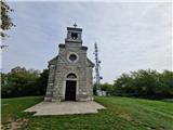
 | Serdica - Serdiški breg (Rdeči breg)
Serdiški breg (Rdeči breg) is a 416 m high hill located right next to the Austrian border. From its grassy summit, which has a few benches and a ...
40 min |
 | border crossing Sotina - Serdiški breg (Rdeči breg)
Serdiški breg (Rdeči breg) is a 416 m high hill located right next to the Austrian border. From its grassy summit, which has a few benches and a ...
35 min |
 | Sotina (Dajčev mlin) - Serdiški breg (Rdeči breg)
Serdiški breg (Rdeči breg) is a 416 m high hill located right next to the Austrian border. From its grassy summit, which has a few benches and a ...
35 min |
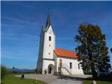
 | Doklece - Janški vrh (by road)
Janški vrh is a 417-meter-high peak on which stands a small namesake settlement and the Church of St. John the Baptist from the 15th century. The...
45 min |
 | Sotina - Sotinski breg (Kugla) (by road)
Sotinski breg (Kugla) is the highest peak of Prekmurje at 418 m. From the summit, which features a wooden observation tower with a bell and cross...
35 min |
 | border crossing Sotina - Sotinski breg (Kugla)
Sotinski breg (Kugla) is the highest peak of Prekmurje at 418 m. From the summit, which features a wooden observation tower with a bell and cross...
45 min |
 | TV Neuhaus am Klausenbach - Sotinski breg (Kugla)
Sotinski breg (Kugla) is the highest peak of Prekmurje at 418 m. From the summit, which features a wooden observation tower with a bell and cross...
35 min |
 | TV Neuhaus am Klausenbach - Stadelberg
Stadelberg is a 418 m high peak located near the highest summit of Prekmurje. A residential house stands at the top, but just a short walk below ...
30 min |
 | Gorica pri Slivnici - Gaj
Gaj is a 419-meter-high hill located above Gorica pri Slivnici. From the logbook box, slightly below the highest point of the hill, there is a be...
30 min |
| Vezovje (bus station Vezovje most) - Gaj
Gaj is a 419-meter-high hill located above Gorica pri Slivnici. From the logbook box, slightly below the highest point of the hill, there is a be...
30 min |
 | Hunting cottage Muljava - Mali Velebit (Petrova gora)
Mali Velebit is a 420-meter-high peak on Petrova gora....
30 min |
 | Zgornja Kungota - Čajžič
Čajžič is a smaller hill located northwest of Zgornja Kungota. Its summit, a popular hiking spot for local residents, has a bench and a logbook b...
35 min |
| Svečina - Čajžič
Čajžič is a smaller hill located northwest of Zgornja Kungota. Its summit, a popular hiking spot for local residents, has a bench and a logbook b...
40 min |
 | Maribor - Samotni bor
Samotni bor is a peak northwest of Maribor, slightly further north and higher than the better-known Piramida, Mestni vrh, and Kalvarija. East of ...
30 min |
 | Gorica pri Slivnici - Peseke
Peseke is a 428-meter-high hill located south of Slivniško Lake. From the viewpoint, where there is also a summit register box and a bench, a bea...
30 min |
 | Tivoli - Šišenski hrib (Rožnik) (by road)
Šišenski hrib, at 429 m, is the highest peak of Rožnik, the hill that rises above the centre of Ljubljana. From the summit, where several transmi...
30 min |
 | Rožna dolina - Šišenski hrib (Rožnik) (via Cankarjev vrh)
Šišenski hrib, at 429 m, is the highest peak of Rožnik, the hill that rises above the centre of Ljubljana. From the summit, where several transmi...
40 min |
 | Donja Višnjica - Vidikovac Tri Žaklji
Tri Žaklji is a viewpoint at 430 meters above sea level. It is located 1.4 km east-southeast of Donja Višnjica and 2 km north to northwest of Gor...
35 min |
 | Gorica pri Slivnici - Gradišče (above Slivniško jezero) (western path)
Gradišče above Slivniško Lake lies between the settlements of Gorica pri Slivnici and Tratna pri Grobelnem. From the logbook box on Gradišče, a f...
30 min |
| Gorica pri Slivnici - Gradišče (above Slivniško jezero) (eastern path)
Gradišče above Slivniško Lake lies between the settlements of Gorica pri Slivnici and Tratna pri Grobelnem. From the logbook box on Gradišče, a f...
35 min |
 | Ljubljana (Zalog) - Castle Stari grad (Stari Osterberg)
Stari grad, or Stari Osterberg, was first mentioned in the 12th century (less likely as early as 1015), at which time the castle belonged to the ...
30 min |
 | Podgrad - Castle Stari grad (Stari Osterberg) (on Ostrovrhar trail)
Stari grad, or Stari Osterberg, was first mentioned in the 12th century (less likely as early as 1015), at which time the castle belonged to the ...
45 min |
 | Polzela - Vinski vrh (Vimperk)
Vinski vrh, or Vimperk, is a hill located north of Polzela. The summit is crowned by the Church of St. Nicholas, next to which stands a small hou...
40 min |
 | Šentjur - Castle Rifnik (Raicheneck)
Rifnik Castle, known as Raicheneck in German, is located on a hill north to north-west of Rifnik. Today, only ruins remain of the castle....
30 min |
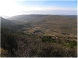
 | Gračišče - Lačna
Lačna is a 451-meter-high hill located between Gračišče, Kubed, and Hrastovlje. The summit, which features a metal observation tower offering nic...
30 min |
 | Komare doline - Lačna
Lačna is a 451-meter-high hill located between Gračišče, Kubed, and Hrastovlje. The summit, which features a metal observation tower offering nic...
35 min |