 | Korita (Church of Our Lady on Brijeg) - Planjak (on road)
Planjak is a scenic summit in the southern part of Mljet Island. A lookout tower crowns the top, providing views in all directions. The peak is c...
45 min |
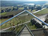
 | Maribor Island - Kalvarija (church of St. Barbara)
Kalvarija is a hill above Maribor largely covered in vineyards. 454 stone steps ("štenge" to Kalvarija) lead to the top. Near the steps stands th...
45 min |
 | Ljubljana (Koseze) - Cankarjev vrh (Rožnik) (by road)
Cankarjev vrh is a 394 m high hill located east of Ljubljana Zoo. From the summit, where a church and a restaurant stand, the surrounding forest ...
1 h |
 | Otovci (football pitch) - Church of St. Anne in Boreča
The Church of St. Anne in Boreča is located above the southwestern part of the settlement on a hill amid a mostly pine forest. In the church, pro...
1 h |
 | Otovci (football pitch) - Vukova kapela (Vidonci)
The Vukova kapela chapel in Vidonci, dedicated to St. Anthony of Padua, stands on a panoramic hill in Goričko. It offers fine views of Goričko, e...
45 min |
 | Ocinje - Sveta Ana pri Igu / Sankt Anna am Aigen
Sveta Ana pri Igu / Sankt Anna am Aigen is a settlement near the border with Slovenia where a church of St. Anne more than 300 years old stands. ...
40 min |
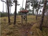
 | Ženavlje (memorial plaque) - Srebrni breg (via cemetery)
Srebrni breg is a 404-meter-high hill in Goričko, offering a nice view over the area. The summit features two benches, a table, and a sign readin...
1 h 5 min |
| Ženavlje (memorial plaque) - Srebrni breg (via chapel)
Srebrni breg is a 404-meter-high hill in Goričko, offering a nice view over the area. The summit features two benches, a table, and a sign readin...
1 h 10 min |
 | Ženavlje (memorial plaque) - Križarka
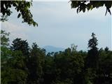
Križarka, also known as Klamnik, is the third highest peak in Prekmurje at 413 meters. The summit is located in a forest and does not offer a par...
1 h 5 min |
| Boreča - Križarka (via Sveta Ana)
Križarka, also known as Klamnik, is the third highest peak in Prekmurje at 413 meters. The summit is located in a forest and does not offer a par...
1 h |
 | border crossing Sotina - Serdiški breg (Rdeči breg) (Austrian path)
Serdiški breg (Rdeči breg) is a 416 m high hill located right next to the Austrian border. From its grassy summit, which has a few benches and a ...
45 min |
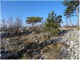 | Komare doline - Krog
Krog is a 418-meter-high hill located between Vrh križa and Kuk. From the summit, which is lightly wooded mainly with pines, there is a view of V...
50 min |
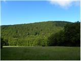 | Zagorica pri Dobrniču - Sveti Križ (Liška gora)
The Church of the Holy Cross is located east of the slightly higher, forested Lisec. From the church, near which there is a large meadow, there i...
40 min |
 | Ljubljana (Koseze) - Šišenski hrib (Rožnik) (by road)
Šišenski hrib, at 429 m, is the highest peak of Rožnik, the hill that rises above the centre of Ljubljana. From the summit, where several transmi...
50 min |
 | Kostanjevica na Krasu - Fajti hrib
Fajti, also known in some records as Fajtji hrib, is a 433-meter-high hill located in the Črni hribi ridge. The summit is known mainly for the fi...
1 h 10 min |
 | Ljubljana (Botanični vrt) - Črni hrib (Golovec)
Črni hrib is a 440 m high hill in the central part of Golovec. The summit, which has a NOB monument and a bench with a table, is crossed by the T...
55 min |
| Ljubljana (Rakovnik) - Črni hrib (Golovec)
Črni hrib is a 440 m high hill in the central part of Golovec. The summit, which has a NOB monument and a bench with a table, is crossed by the T...
50 min |
 | Ljubljana (Gruberjeva brv) - Črni hrib (Golovec)
Črni hrib is a 440 m high hill in the central part of Golovec. The summit, which has a NOB monument and a bench with a table, is crossed by the T...
50 min |
| Ljubljana (Štepanja vas) - Črni hrib (Golovec)
Črni hrib is a 440 m high hill in the central part of Golovec. The summit, which has a NOB monument and a bench with a table, is crossed by the T...
50 min |
 | Podgrad - Castle Stari grad (Stari Osterberg) (via millstone quarry)
Stari grad, or Stari Osterberg, was first mentioned in the 12th century (less likely as early as 1015), at which time the castle belonged to the ...
45 min |
 | Podgrad - Murjevka
Murjevka is a 443-meter-high peak above the valley of the Besnica stream, south of Podgrad. The summit is located in the forest so it doesn't off...
40 min |