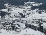
 | Tremerje - Kamčič (on the ridge of Mali Slomnik)
Kamčič is a wooded peak in the Posavje Hills, located north of Šmohor between Kotečnik to the left and Veliki Slomnik to the right. It is recogni...
1 h 15 min |
 | SSK Sam Ihan - Sveta Trojica (above Dob) (via Dobovlje)
Sveta Trojica is a village located southeast of Dob pri Domžalah. In the upper part of the village, on a scenic hill, stands the Church of the Ho...
1 h 50 min |
 | Kisovec - Castle Gamberk
Castle Gamberk (German: Gallenberg) is a castle situated on a hill above the settlement of Ržiše in the Posavsko hribovje....
1 h 10 min |
| Zagorje ob Savi - Castle Gamberk
Castle Gamberk (German: Gallenberg) is a castle situated on a hill above the settlement of Ržiše in the Posavsko hribovje....
1 h 35 min |
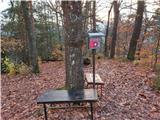 | Celje (hanging bridge) - Hom above Celje (via Petriček and Lisce)
Hom is a forest-covered peak located north of Košnica pri Celju. The summit features a logbook box and a small bench....
1 h 10 min |
 | Naraplje - Kerješetov vrh
Kerješetov vrh is a 590-meter-high hill located above the settlement of Jelovice. The summit is overgrown with forest, so there is no good view f...
1 h 30 min |
 | Stoperce - Joški vrh
Joški vrh is a 595-meter-high peak located on the northern side of Donačka gora. A short unmarked path leads to the summit, branching off from th...
1 h 35 min |
| Sveti Jurij - Joški vrh
Joški vrh is a 595-meter-high peak located on the northern side of Donačka gora. A short unmarked path leads to the summit, branching off from th...
1 h 5 min |
 | Ruše - Globokarjev vrh
Globokarjev vrh is situated on a small ridge between Drava and Lobnica, only a few minutes away from the Globokar farm. Several antennas stand on...
1 h 15 min |
 | Spodnje Tinsko - Lendrše
Lendrše is a 617-meter-high peak on Rudnica from which beautiful views open towards Boč....
1 h 35 min |
| Olimje - Lendrše
Lendrše is a 617-meter-high peak on Rudnica from which beautiful views open towards Boč....
1 h 20 min |
| Slake (Church of the Virgin Mary on Pesek) - Lendrše
Lendrše is a 617-meter-high peak on Rudnica from which beautiful views open towards Boč....
1 h 50 min |
| Podčetrtek (sveti Lovrenc) - Lendrše
Lendrše is a 617-meter-high peak on Rudnica from which beautiful views open towards Boč....
1 h 40 min |
| Podčetrtek (Terme Olimia) - Lendrše (past castle Podčetrtek)
Lendrše is a 617-meter-high peak on Rudnica from which beautiful views open towards Boč....
1 h 55 min |
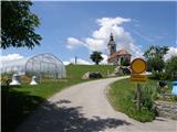
 | Olimje - Olimska gora (past lake Zmajevo jezero)
Olimska gora lies above Olimje on Rudnica. Its forested summit offers no scenic views....
1 h 25 min |
 | Sora - Breznik (Boben)
Breznik, also known as Boben, is a 643-meter-high peak situated above the right bank of the Ločnica, more precisely above Sora, Rakovnik, Goričan...
1 h 5 min |
 | Izlake (Medijske toplice) - Vrhija (via Podlipovica)
Vrhija is a 648-meter-high hill located west of Izlake and east of Kolovrat. It lies between Kalanov hrib and Kolovraška reber, viewed from the N...
1 h 15 min |
 | Graz Center West - Buchkogel (Rudolfswarte) (via St. Martin)
Buchkogel, also known as Graz Buchkogel, is located west of Graz and, alongside Plabutsch, is one of the most popular excursion destinations on t...
1 h 30 min |
 | Marof pri Pišecah - Intermedija (via Velika bukva)
Intermedija is a 662-meter-high peak in the Orlica range. From the summit, there is a beautiful view mainly to the north and northeast, where on ...
1 h 10 min |
 | Spodnje Pirniče - Grmada (Kovačeva steza)
Grmada is a 676-meter-high mountain located west of the much more visited Šmarna gora. From the summit, which has a small takeoff area, a beautif...
1 h 10 min |
 | Rakovnik - Sveti Florijan (Tehovec) (via Breznik)
The Church of St. Florijan is a subsidiary church located in the village of Tehovec above Medvode. From the church, first mentioned in 1548, a ni...
1 h 20 min |
 | Vas (sports field) - Sveti Jurij (Remšnik)
The Church of St. Jurij is located on a panoramic hill in the Remšnik settlement, which lies on the slopes of Kozjak. Opposite the church, next t...
1 h 45 min |
 | Marof pri Pišecah - Veliki Špiček
Veliki Špiček is the highest peak of Brežice municipality. From the top a nice view spreads towards the south and east. Most of Brežice municipal...
1 h 10 min |
 | Puščava - Lobnikov vrh
Lobnikov vrh is a forested peak above the Dravska dolina valley, located between the settlements of Fala and Ruta. From the east, due to its remo...
1 h 20 min |
| Fala Grad - Lobnikov vrh
Lobnikov vrh is a forested peak above the Dravska dolina valley, located between the settlements of Fala and Ruta. From the east, due to its remo...
1 h 15 min |
 | Srednja vas - Koreno
Koreno (also known as Korena) is a 729 m high hill located north of Horjul. From the summit, which features a large cross, the church of St. Moho...
1 h 20 min |
 | Rudnik pri Radomljah - Tolsta gora
Tolsta gora is a 734-meter-high mountain located above the settlement of Vrhpolje pri Kamniku. From the summit, where a cairn stands, there is no...
1 h 25 min |
| Pravdan - Tolsta gora (via Čeh)
Tolsta gora is a 734-meter-high mountain located above the settlement of Vrhpolje pri Kamniku. From the summit, where a cairn stands, there is no...
1 h 45 min |
 | Škofja Loka - Vrh soteske (Križna gora)
Vrh soteske is a 735 meters high peak, which is situated on the southwestern part of Križna gora. From the top, which is overgrown by the forest,...
1 h 25 min |
| Vešter - Vrh soteske (Križna gora)
Vrh soteske is a 735 meters high peak, which is situated on the southwestern part of Križna gora. From the top, which is overgrown by the forest,...
1 h 15 min |
 | Rudnik pri Radomljah - Vrtače (via Lancar)
Vrtače is a 758-meter-high peak located above the village of Zgornje Palovče. The summit is overgrown with forest, but from a clearing slightly b...
1 h 30 min |
| Pravdan - Vrtače (via Zgornje Palovče)
Vrtače is a 758-meter-high peak located above the village of Zgornje Palovče. The summit is overgrown with forest, but from a clearing slightly b...
1 h 45 min |
 | Liboje (quarry) - Kotečnik (via eastern ridge)
Kotečnik is a peak in the Posavsko hribovje, located north of Šmohor. It is a summit with two logboxes: the first on the western subpeak, offerin...
1 h 5 min |