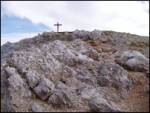
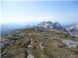
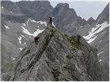
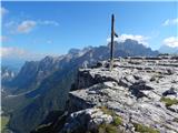
 | Dom pod Storžičem - Storžič (through Žrelo)
Storžič is a 2132 m high mountain located in the western part of the Kamnik-Savinja Alps. From the summit, where there is a cross, a beautiful vi...
3 h |
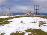
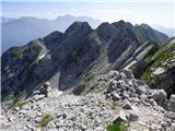
 | Bukovnik - Velika Raduha (climbing way)
Velika Raduha, at 2062 m, is the highest peak of the Raduha range, which rises steeply east of Robanov Kot. From the summit, with its registratio...
2 h 25 min |
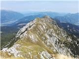
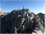
 | Vršič - Mala Mojstrovka (Hanzova pot)
Mala Mojstrovka is one of the most visited peaks in the Julian Alps due to the relatively high elevation of its starting point. From the summit, ...
2 h 15 min |
| Erjavčeva koča na Vršiču - Mala Mojstrovka (Hanzova pot)
Mala Mojstrovka is one of the most visited peaks in the Julian Alps due to the relatively high elevation of its starting point. From the summit, ...
2 h 25 min |
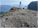
 | Koschutahaus - Koschutnikturm (Košutnikov turn) (ÖTK Steig Neu)
Košutnikov Turn is the highest peak in Košuta, the longest Slovenian ridge. The summit offers a beautiful view of the entire ridge. Austria and t...
2 h 45 min |
 | Cason di Lanza - Creta di Aip / Trogkofel (ferrata Crete Rose)
Veliki Koritnik / Creta di Aip / Trogkofel is the highest peak in the Mokrine / Nassfeld pass area. The mountain has a gentle summit from which s...
3 h 30 min |
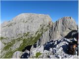
 | Parking place below Nassfeld - Monte Cavallo / Rosskofel (by east ridge)
Konjski Špik / Monte Cavallo di Pontebba / Rosskofel is a 2,240-meter-high and highly panoramic mountain in the main ridge of the Carnic Alps in ...
3 h 30 min |
 | Jochalm - Kleiner Reißkofel (path 235)
Kleiner Reißkofel is a 2,161-meter-high mountain east of Reißkofel. From the summit, where a cross stands, there are fine views of the nearby Rei...
2 h 25 min |
 | Lienzer Dolomitenhütte - Große Gamswiesenspitze (Normalweg)
Große Gamswiesenspitze is a 2,488-meter-high mountain located in the heart of the Lienz Dolomites. From the summit, which features a summit logbo...
3 h 30 min |
 | Lienzer Dolomitenhütte - Kleine Gamswiesenspitze
Kleine Gamswiesenspitze is a steep and sharp mountain located near the larger Große Gamswiesenspitze. From its precipitous summit, there is a bea...
3 h 30 min |
 | Plockenpass - Creta di Collinetta / Cellon (Via ferrata Steinberger Weg)
Creta di Collinetta / Cellon is a 2,238-meter-high mountain located west of the Plöcken Pass. From the summit, which features a cross, there is a...
3 h |
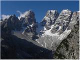
 | Rifugio Sorgenti del Piave - Monte Chiadenis (southwest route)
Monte Chiadenis is a 2,459-meter-high mountain located between Monte Peralba and the Crete Cacciatori peak. From the summit, which has a summit r...
2 h |
 | Rifugio Sorgenti del Piave - Monte Chiadenis (CAI di Portogruaro)
Monte Chiadenis is a 2,459-meter-high mountain located between Monte Peralba and the Crete Cacciatori peak. From the summit, which has a summit r...
2 h 30 min |
 | Carbonin - Monte Fumo / Rauhkofel (Northern route)
Monte Fumo / Rauhkofel is a 2114-meter-high mountain in the Cristallo group. From the summit, located right next to the group's highest peaks, th...
2 h 30 min |
| Carbonin - Monte Fumo / Rauhkofel
Monte Fumo / Rauhkofel is a 2114-meter-high mountain in the Cristallo group. From the summit, located right next to the group's highest peaks, th...
2 h 45 min |
 | Landro - Monte Piano (Via Ferrata Bilgeri)
Monte Piano (Toblacher Kreuz) is a 2,305-meter-high mountain located on the northwestern edge of the Monte Piana plateau. Near the summit there a...
3 h |
 | Karnica / Sella Carnizza - Monte Musi (western peak)
Vrh Muzcev (western peak) is located in the central part of the Muzcev Ridge, separating Rezija Valley and Terska Valley. Its 1,864-meter summit,...
3 h 30 min |