 | Mače - Bašeljski vrh (via valley of Suha and via Kališče)
Bašeljski vrh is a 1744-meter-high mountain located between Mali Grintovec and Storžič. From the summit, where there is a bench and a registratio...
3 h 25 min |
 | Smrečje - Plešivec (by road)
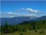
Plešivec is an 1801 m high peak situated south of the eastern part of Košuta. From the summit, where a border marker stands, there is a beautiful...
3 h 30 min |
 | Rosenbach - Klek
Klek is a 1753-metre-high mountain located between Hruški vrh and the better-known Golica. The summit, on the border between Slovenia and Austria...
3 h 40 min |
 | Bela Peč - Vivodnik (past peak Seduc)
Vivodnik, at 1508 meters, is the highest peak of Menina planina, a plateau rising south of Gornji Grad. From the summit, which has a small observ...
4 h 20 min |
| Bela Peč - Vivodnik (via Ovčje jame)
Vivodnik, at 1508 meters, is the highest peak of Menina planina, a plateau rising south of Gornji Grad. From the summit, which has a small observ...
4 h 25 min |
 | Javorje (Mala Črna) - Komen (via Hlipovec)
At 1684 meters, Komen is the highest peak in the Smrekovec mountain range, which borders between Styria and Carinthia. In good weather, the summi...
4 h 20 min |
 | Javorje (Mala Črna) - Veliki Travnik (Turnovka) (steep path)
Veliki Travnik, also known as Turnovka by the locals, is located on the western edge of the Smrekovec mountain range. From the summit, which has ...
4 h 25 min |
 | Trbiž / Tarviso - Svete Višarje / Monte Lussari (on transport road)
Svete Višarje / Monte Lussari is a pilgrimage site for Slavs, Germans, and Romance peoples. Already in the 16th century, the mountain was called ...
3 h 25 min |
 | Tolminske Ravne - Žabiški Kuk (on mule track)
Žabiški Kuk is located on the southern side ridge of the Lower Bohinj Mountains near the more renowned Vogel and above Planina Razor. From the su...
3 h 45 min |
 | Stržišče - Jehlc (Špičasta kupa)
Different maps list various names for Jehlc, which also vary in elevation. Locals call the peak Jehlc (1625 m), while newer maps show Jehelc and ...
3 h 30 min |
 | Kosmačev preval - Lengarjeva glava
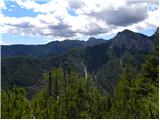
Lengarjeva glava is a 1,498 m high peak situated between the Vrata and Kot valleys. From the partly vegetated summit, a nice view opens up on Deb...
3 h 30 min |
 | Ribčev Laz - Hunting cottage Na Glinu
The hunting cottage Na Glinu is situated on a panoramic hill between the mountain pastures Suha and Poljana. From the cottage there opens a nice ...
3 h 30 min |
 | Jasna - Visoka peč (via Mojčin dom)
Visoka peč is a 1,749-meter-high mountain located southwest of Ciprnik. From its summit, which steeply descends towards Planica and features a sm...
3 h 30 min |
| Kranjska Gora - Visoka peč (via Bedančev dom)
Visoka peč is a 1,749-meter-high mountain located southwest of Ciprnik. From its summit, which steeply descends towards Planica and features a sm...
3 h 25 min |
 | Rebrca / Rechberg - Stara gora / Altberg (via Rokov vrh)
Stara gora is a 1,552-meter-high peak located northeast of Ojstrca, the highest peak of Obir. On the summit stand a wooden cross and a bench, wit...
3 h 10 min |
 | Sele-Zvrhnji Kot (Male) / Zell-Oberwinkel (Male) - Hajnžev Praprotnik / Zeller Prapotnik
Hajnžev Praprotnik is a 1,727-metre peak on the Austrian side of the Karawanks, more precisely between Košutica and the settlement of Sele-Zvrhnj...
3 h 55 min |
 | Tržič - Robič (via Kamnek and Zavetišče na Kalu)
Robič is a 1,384-meter-high peak located between the Tržiška Bistrica Valley and the Košuta ridge. From the summit, there is a beautiful view mai...
3 h 35 min |
 | Bistrica v Rožu / Feistritz im Rosental - Rabenberg
Rabenberg is a 1,465 m high peak located in the Žingarica / Singerberg ridge. From the summit, there is a partial view to the northwest, while fo...
3 h 20 min |
 | Spodnja Trenta - Na Glavi
Na Glavi (or Na Glavah) is a 1,666-meter-high peak above Stari Utro. From the summit, overgrown with dwarf pines, there is a very nice view of nu...
3 h 25 min |
 | Unternberg - Schöberlriegel (via Kampstein)
Schöberlriegel is a 1,704-meter-high peak situated north of Hochwechsel. From the summit, where a large cairn stands, a beautiful view opens up o...
4 h 20 min |
| St. Corona am Wechsel - Schöberlriegel
Schöberlriegel is a 1,704-meter-high peak situated north of Hochwechsel. From the summit, where a large cairn stands, a beautiful view opens up o...
4 h 20 min |
 | Unternberg - Umschussriegel (via Kampstein)
Umschussriegel is a panoramic peak situated between Feistritzsattel pass and the Hochwechsel peak. From the grassy summit, a beautiful view opens...
4 h 20 min |
| St. Corona am Wechsel - Umschussriegel
Umschussriegel is a panoramic peak situated between Feistritzsattel pass and the Hochwechsel peak. From the grassy summit, a beautiful view opens...
4 h 40 min |
 | Aflenz Kurort (Freibad Aflenz) - Hochstein (at Mitteralm) (via Windgrube)
Hochstein is a scenic summit with a cross and summit register box in the Hochschwab mountain group, between Windgrube peak and the Mitteralm plat...
3 h 35 min |
| Aflenz Kurort (Bürgergraben) - Hochstein (at Mitteralm) (via Windgrube)
Hochstein is a scenic summit with a cross and summit register box in the Hochschwab mountain group, between Windgrube peak and the Mitteralm plat...
3 h 35 min |