 | Lenart v Slovenskih goricah - Zavrh v Slovenskih goricah (via lake Radehova)
Zavrh is a village in the Slovenske gorice, known to hikers primarily as a checkpoint on the extended Slovenian mountain trail. In the center of ...
1 h 20 min |
 | Gornji Senik / Felsőszölnök - Tromejnik / Dreiländerecke / Harmashatar
Tromejnik, known in German as Dreiländerecke or in Hungarian as Hármashatár, is a 390 m high hill located at the tripoint between Slovenia, Austr...
1 h 30 min |
 | border crossing Matjaševci - Holzmannkogel
Holzmannkogel is a 393-meter-high hill located north of Tromejnik. The summit is forested and offers no significant views....
1 h 15 min |
 | border crossing Kramarovci - Sveta Ana pri Igu / Sankt Anna am Aigen
Sveta Ana pri Igu / Sankt Anna am Aigen is a settlement near the border with Slovenia where a church of St. Anne more than 300 years old stands. ...
1 h |
 | Komare doline - Sveti Kvirik
The church or chapel of St. Kvirik (also listed on maps and elsewhere as St. Kirk, Kirik, Kvirk, Kvirin, or Kirin) stands on a panoramic rise bet...
1 h 20 min |
 | Serdica - Serdiški breg (Rdeči breg) (via Brunarjev breg)
Serdiški breg (Rdeči breg) is a 416 m high hill located right next to the Austrian border. From its grassy summit, which has a few benches and a ...
50 min |
 | Sotina - Sotinski breg (Kugla) (via the source of mineral water)
Sotinski breg (Kugla) is the highest peak of Prekmurje at 418 m. From the summit, which features a wooden observation tower with a bell and cross...
50 min |
 | OMP Kuzma - Sotinski breg (Kugla)
Sotinski breg (Kugla) is the highest peak of Prekmurje at 418 m. From the summit, which features a wooden observation tower with a bell and cross...
1 h |
 | OMP Kuzma - Stadelberg
Stadelberg is a 418 m high peak located near the highest summit of Prekmurje. A residential house stands at the top, but just a short walk below ...
55 min |
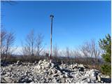
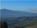 | Pernica - Vavtošek
Vavtošek is a scenic summit in the Slovenske Gorice on which several transmitters stand. From the top there is a fine view mainly towards the sou...
1 h 5 min |
 | Phliški bajer - Mengeška koča on Gobavica (lower path)
Gobavica is a hill rising above Mengeš. Mengeška koča mountain hut stands on it, along with a goat pen. It is one of the starting points for the ...
1 h |
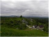
 | Vojnik - Sveti Tomaž above Vojnik
Sv. Tomaž is a church on a partly vegetated 444 m high summit near Vojnik. There is a logbook with a stamp at the top. Below the summit stands th...
1 h |
 | Suhadole - Koseški hrib (via Mlinčki)
Koseški hrib is located between Kuharjev boršt and Koseze, the settlement after which the peak is also named. From the summit, which has a table,...
50 min |
| Bukovica pri Vodicah - Koseški hrib (via Mlinčki)
Koseški hrib is located between Kuharjev boršt and Koseze, the settlement after which the peak is also named. From the summit, which has a table,...
50 min |
 | Topole - Koseški hrib
Koseški hrib is located between Kuharjev boršt and Koseze, the settlement after which the peak is also named. From the summit, which has a table,...
55 min |
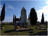
 | Kamnik - Sveta Ana (Tunjice)
The Baroque church of St. Ana in Tunjice is located on a hill west of Kamnik. Near the church is a summit register box, and slightly offside is t...
1 h |
 | Snack Bar Zelena dolina - Church of Our Lady of Loreto in Ložno
The Church of Our Lady of Loreto at Ložno stands on a panoramic hill northeast of Rogaška Slatina. A chapel and an NOB monument stand by the chur...
1 h 5 min |
| Brzika - Church of Our Lady of Loreto in Ložno
The Church of Our Lady of Loreto at Ložno stands on a panoramic hill northeast of Rogaška Slatina. A chapel and an NOB monument stand by the chur...
55 min |
 | Zazid - Kuk
Kuk (also known as Ščukovec on some maps) is a 498-meter-high hill north of the village Movraž. From the summit, which features a small cross, th...
1 h |
 | Gaber pri Semiču - Smuk (via Smuška cesta)
Smuk is a 545-meter-high peak above Semič. The summit features the Church of St. Lawrence, a hunting cabin, and nearby ruins of Smuk (or Turn) Ca...
50 min |