 | Jevnica - Janče
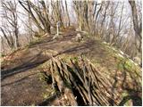
Janče is a 792-meter-high peak situated between the Sava River and the Besnica stream valley. From the summit, where a mountain hut stands and th...
1 h 45 min |
 | Kamnje - Mala gora
Mala gora is a plateau on the slope of Čavna. At 1034 meters' altitude, there is a hut. Mala gora is known for its flowers that are unique to thi...
2 h |
 | Breg (Liški potok) - Lisca
Lisca is a panoramic peak located north of Sevnica. From the summit, where a meteorological radar station stands, there are fine views of Posavsk...
2 h 5 min |
| Krakovo (Mastnak wine cellar) - Lisca (via Skalce)
Lisca is a panoramic peak located north of Sevnica. From the summit, where a meteorological radar station stands, there are fine views of Posavsk...
1 h 50 min |
| Krakovo (Mastnak wine cellar) - Lisca (Pastirčkova pot)
Lisca is a panoramic peak located north of Sevnica. From the summit, where a meteorological radar station stands, there are fine views of Posavsk...
1 h 55 min |
| Krakovo (Mastnak wine cellar) - Lisca (past Sveti Jošt)
Lisca is a panoramic peak located north of Sevnica. From the summit, where a meteorological radar station stands, there are fine views of Posavsk...
1 h 55 min |
 | Breg - Sveti Lovrenc (above Okroglice)
The Church of St. Lovrenc is located east of Zidani Most and northwest of Sevnica, above the village of Okroglice and near the Lovrenc peak. From...
1 h 45 min |
| Dolina Gračnice (Blatnik) - Sveti Lovrenc (above Okroglice)
The Church of St. Lovrenc is located east of Zidani Most and northwest of Sevnica, above the village of Okroglice and near the Lovrenc peak. From...
1 h 45 min |
 | Source of Hubelj - Sinji vrh (via Otliško okno)
Sinji vrh is a panoramic mountain between Col, Ajdovščina, and Predmeja. It offers views across much of western Slovenia (the sea on clear days)....
2 h 15 min |
 | Source of Hubelj - Navrše
Navrše is a little-known peak southeast of Otliško okno. It offers nice views of the Vipava Valley and the peaks surrounding it....
1 h 35 min |
 | Gračnica - Veliko Kozje
Veliko Kozje is a mountain that rises steeply above the left bank of the Savinja River, descending more gently towards the Sava River. The highes...
2 h 15 min |
 | Laško - Dom na Šmohorju
The mountain hut Dom na Šmohorju is located between Laško, Liboje, and Zabukovica. From the hut, or from the church of St. Mohor just a few minut...
2 h |
 | Laško - Malič
Malič is a 936-meter-high peak situated between Celje and Laško, more precisely above Spodnja Rečica. From the summit, which has a transmitter, b...
2 h 15 min |
 | Tremerje - Malič (on western ridge of Malič)
Malič is a 936-meter-high peak situated between Celje and Laško, more precisely above Spodnja Rečica. From the summit, which has a transmitter, b...
2 h |
 | Gradišče pri Vipavi - Gradiška Tura (via Plaz)
Gradiška Tura is a prominent 754-meter peak rising at the far western edge of the Nanos plateau directly above the Vipava Valley. Thanks to its e...
2 h |
 | Zagrad - Grmada above Celje (gentle path)
What Šmarna gora is to people from Ljubljana, Grmada is to those from Celje. Celje's local mountain lies south of the town above Zagrad village. ...
1 h 30 min |
 | Zagrad - Tolsti vrh above Celjska koča (eastern way)
Tolsti vrh (also recorded as Tovsti vrh in some sources) is situated above the Celjska koča ski area. The summit has a logbook box and stamp, but...
1 h 45 min |
 | Zagrad - Tolsti vrh above Celjska koča (Po vrheh)
Tolsti vrh (also recorded as Tovsti vrh in some sources) is situated above the Celjska koča ski area. The summit has a logbook box and stamp, but...
1 h 40 min |
 | Štore - Tolsti vrh above Celjska koča (via Žlajfa)
Tolsti vrh (also recorded as Tovsti vrh in some sources) is situated above the Celjska koča ski area. The summit has a logbook box and stamp, but...
2 h 15 min |
 | Štore - Tolsti vrh above Celjska koča (via Marija)
Tolsti vrh (also recorded as Tovsti vrh in some sources) is situated above the Celjska koča ski area. The summit has a logbook box and stamp, but...
2 h |
 | Renke - Ostrež
Ostrež is an 856 m high hill in the Posavje Hills. It rises south of the Sava River valley, above the main LitijaZagorje ob Savi road....
1 h 30 min |
 | Izlake - Pleše (via Grobovščica)
Pleše is an 866-meter-high peak situated between the Marela ski slope and Zasavska Sveta gora. From the summit, which features a NOB monument, th...
2 h 15 min |
 | Izlake - Pleše (via Vežnica)
Pleše is an 866-meter-high peak situated between the Marela ski slope and Zasavska Sveta gora. From the summit, which features a NOB monument, th...
1 h 45 min |
 | Štore - Veliki vrh above Svetina (via Žlajfa and via Svetina)
Veliki vrh lies southwest of the settlement of Svetina above Štore. It is settled high up mainly from the south side, with one homestead directly...
2 h 15 min |
 | Studenice - Plešivec (at Boč)
Peace, silence, varied terrain... these are characteristics of the peak at the crossroads of numerous paths between the Maribor, Celje, and Ptuj ...
2 h |
 | Studenice - Plešivec (at Boč) (final part on forest road)
Peace, silence, varied terrain... these are characteristics of the peak at the crossroads of numerous paths between the Maribor, Celje, and Ptuj ...
2 h |
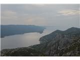 | Bilopolje - Sveti Ilija (Pelješac)
Sveti Ilija, also Zmijino brdo, is a 961-meter-high mountain and the highest peak of the Pelješac Peninsula. From the top, a nice view opens up o...
2 h 20 min |
 | Railway station (Most na Soči) - Viewpoint Široko
The viewpoint lies at 755 m above Most na Soči in the namesake hamlet of Tolminski Lom. Access is possible by car to the nearby tourist farm or o...
1 h 40 min |
 | Radoboj - Sekolje (Strahinjčica)
Sekolje is the easternmost peak of Strahinjčica. It appears as an interesting cone shape from the surrounding areas. The view from the peak is li...
1 h 30 min |
 | Žabče (road to Tolminske Ravne) - Poloje
Poloje is a 981-meter-high peak with a summit register, located in the Julian Alps, more precisely between Žabijski vrh and Tolminski Triglav....
2 h |