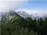
 | Rosenbach - Kahlkogel/Golica (via Medji dol)
Golica is an unvegetated peak located north of Jesenice. From the summit, where a registration box is placed, there is a fine view of the western...
3 h 45 min |
| Rosenbach - Kahlkogel/Golica (via Quadiaalm)
Golica is an unvegetated peak located north of Jesenice. From the summit, where a registration box is placed, there is a fine view of the western...
3 h 35 min |
| Tallach - Kahlkogel/Golica (via Quadiaalm)
Golica is an unvegetated peak located north of Jesenice. From the summit, where a registration box is placed, there is a fine view of the western...
3 h 50 min |
 | Povlje - Bašeljski vrh
Bašeljski vrh is a 1744-meter-high mountain located between Mali Grintovec and Storžič. From the summit, where there is a bench and a registratio...
3 h 50 min |
| Laško - Bašeljski vrh (via Sveti Lovrenc)
Bašeljski vrh is a 1744-meter-high mountain located between Mali Grintovec and Storžič. From the summit, where there is a bench and a registratio...
3 h 40 min |
| Bašelj - Bašeljski vrh (via Sveti Lovrenc)
Bašeljski vrh is a 1744-meter-high mountain located between Mali Grintovec and Storžič. From the summit, where there is a bench and a registratio...
4 h 15 min |
 | Povlje - Mali Grintovec (via Bašeljski vrh)
Mali Grintovec is a panoramic mountain located east of Storžič. From the summit, which has a summit register box, stamp, and a pleasant bench, th...
4 h 35 min |
 | Laško - Mali Grintovec (via Sveti Lovrenc)
Mali Grintovec is a panoramic mountain located east of Storžič. From the summit, which has a summit register box, stamp, and a pleasant bench, th...
4 h 25 min |
| Bašelj - Mali Grintovec (via Sveti Lovrenc)
Mali Grintovec is a panoramic mountain located east of Storžič. From the summit, which has a summit register box, stamp, and a pleasant bench, th...
4 h 50 min |
| Povlje - Mali Grintovec
Mali Grintovec is a panoramic mountain located east of Storžič. From the summit, which has a summit register box, stamp, and a pleasant bench, th...
4 h 25 min |
 | Hotel Plesnik - Strelovec (via Plesnikova planina)
This scenic peak is situated between two Alpine valleys: Logarska dolina and Robanov kot. The view from the summit is most beautiful towards the ...
3 h 30 min |
 | Gostišče Firšt - Govca (Olševa)
Govca is the highest peak of the Olševa range, rising above Koprivna, Solčava, and Remšenik (Remšenik/Remschenig is a valley on the Austrian side...
3 h 45 min |
 | Breginj - Stol (Julian Alps)
Stol (1673 m) is located in the longest ridge of the Julian Alps. The ridge measures 25 km, or 35 km if including the western part. From the summ...
3 h 10 min |
| Breginj - Stol (Julian Alps) (via Muzec)
Stol (1673 m) is located in the longest ridge of the Julian Alps. The ridge measures 25 km, or 35 km if including the western part. From the summ...
4 h 45 min |
 | Crni Lug - Veliki Risnjak (Horvatova staza)
Veliki Risnjak, at 1528 m, is the highest peak of Risnjak National Park. From the summit, which has a logbook box and stamp, there is a very nice...
3 h 30 min |
 | Breginj - Punta di Montemaggiore
Breški Jalovec, or Punta di Montemaggiore in Italian, is a 1613-meter-high mountain located above the source of the Nadiža River, specifically on...
5 h |
 | Sele-Zvrhnji Kot (Male) / Zell-Oberwinkel (Male) - Lokovnikov Grintovec / Grintoutz
Lokovnikov Grintovec is a dwarf pine-covered peak north of Košutica, separated from it by Dovjakovo sedlo saddle (1,728 m). Its southwestern and ...
4 h |
 | Čadrg - Tolminski Migovec
Tolminski Migovec is a 1881 m high mountain. Its western slope above the Tolminka valley is the steepest and most scenic. The southern slope is i...
3 h 30 min |
 | Gornje Sitno - Vickov stup (via Klančac and Ljubljana)
Vickov stup is a red decagonal tower located on a minor summit on Mosor, west of Ljubirna. Inside the tower are benches and a logbook. In bad wea...
5 h |
 | Gornje Sitno - Vickov stup (via Ljuvač and past Kabal)
Vickov stup is a red decagonal tower located on a minor summit on Mosor, west of Ljubirna. Inside the tower are benches and a logbook. In bad wea...
3 h 30 min |
 | Gornje Sitno - Ljubirna (via Klančac and Ljubljana)
Ljubirna is the second-highest peak on Mosor. It lies east of Vickov stup. A concrete pillar at the summit bears the peak's name and elevation. T...
5 h 5 min |
 | Gornje Sitno - Ljubirna (via Ljuvač and past Kabal)
Ljubirna is the second-highest peak on Mosor. It lies east of Vickov stup. A concrete pillar at the summit bears the peak's name and elevation. T...
3 h 25 min |
 | parking lot Hoyer (Neuhofgraben) - Lärchkogel (Gleinalpe) (via Speikkogel)
Lärchkogel is a 1,894-meter peak in the Gleinalpe massif with a cross and a small shelter beside it. From the summit, there are fine views of Spe...
4 h 15 min |