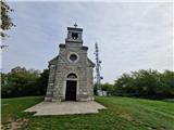
 | Lendava (Tuš Supermarket Kocet) - Piramida (Lendavske gorice)
The Piramida is a stone marker on the highest point of Lendavske gorice, where there is also a logbook box and a stamp of the Pomurje mountain tr...
45 min |
| Lendava (TIC Lendava) - Piramida (Lendavske gorice)
The Piramida is a stone marker on the highest point of Lendavske gorice, where there is also a logbook box and a stamp of the Pomurje mountain tr...
40 min |
| Dolga vas - Piramida (Lendavske gorice)
The Piramida is a stone marker on the highest point of Lendavske gorice, where there is also a logbook box and a stamp of the Pomurje mountain tr...
40 min |
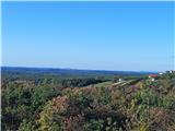
 | Pusztaszentlászló - Hahót hegy
Hahót hegy is the second highest peak of the Zala Hills / Zalai dombság. The summit is covered in forest and offers no views....
45 min |
 | Ladvenjak - Martinščak (težja pot)
Martinščak is a 345-meter hill in the Kordun region, located southeast of Karlovac. At the summit there is the Chapel of Saint Martin, built in 1...
25 min |
| Ladvenjak - Martinščak (lažja pot)
Martinščak is a 345-meter hill in the Kordun region, located southeast of Karlovac. At the summit there is the Chapel of Saint Martin, built in 1...
30 min |
 | Podčetrtek (Terme Olimia) - Castle Podčetrtek
Castle Podčetrtek, or Windischlandsberg in German, is located on a hill above Podčetrtek along a marked trail leading to Silavec or the Tower of ...
30 min |
 | Gyulakeszi - Csobánc
Csobánc is one of numerous extinct volcanoes near the town of Tapolca. Remains of an old fortress are at the volcano's summit, making the peak h...
35 min |
 | Gornji Četar / Felsőcsatár - Nagyvilágos mérőtorony (path by river Pinka)
Nagyvilágos mérőtorony is a former geodetic tower now converted into a lookout tower. It stands atop Četarski breg in western Vas County (Železna...
45 min |
 | Gornji Četar / Felsőcsatár - Nagyvilágos mérőtorony (pot zeleni trikotnik)
Nagyvilágos mérőtorony is a former geodetic tower now converted into a lookout tower. It stands atop Četarski breg in western Vas County (Železna...
35 min |
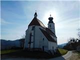
 | Čatež ob Savi - Sveti Vid (Šentviška gora)
The Church of St. Vitus is located at the summit of Šentviška gora, which rises steeply south of Čatež along the Sava River. It is an extremely p...
35 min |
| Čatež ob Savi - Sveti Vid (Šentviška gora) (Leseni križev pot)
The Church of St. Vitus is located at the summit of Šentviška gora, which rises steeply south of Čatež along the Sava River. It is an extremely p...
35 min |
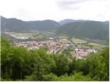
 | Gorenja Žaga - Kostel Castle
Kostel Castle sits on a panoramic hill above the left bank of the Kolpa River. From the castle, which together with its associated settlement for...
35 min |
 | Spodnje Tinsko - Tinska gora
Tinska gora, at an elevation of 409 meters, lies on the ridge separating the valleys of Zibiški potok and Tinski potok streams. Despite its low a...
30 min |
 | Hrastovica - Cepeliš (past waterworks)
Cepeliš is the highest peak of Hrastovička gora, located slightly south of the town Petrinja. The summit was also known for its trigonometric tow...
45 min |
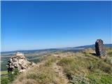
 | Serdica - Serdiški breg (Rdeči breg)
Serdiški breg (Rdeči breg) is a 416 m high hill located right next to the Austrian border. From its grassy summit, which has a few benches and a ...
40 min |
 | border crossing Sotina - Serdiški breg (Rdeči breg)
Serdiški breg (Rdeči breg) is a 416 m high hill located right next to the Austrian border. From its grassy summit, which has a few benches and a ...
35 min |
 | Sotina (Dajčev mlin) - Serdiški breg (Rdeči breg)
Serdiški breg (Rdeči breg) is a 416 m high hill located right next to the Austrian border. From its grassy summit, which has a few benches and a ...
35 min |
 | Doklece - Janški vrh (by road)
Janški vrh is a 417-meter-high peak on which stands a small namesake settlement and the Church of St. John the Baptist from the 15th century. The...
45 min |
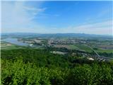
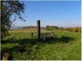
 | Sotina - Sotinski breg (Kugla) (by road)
Sotinski breg (Kugla) is the highest peak of Prekmurje at 418 m. From the summit, which features a wooden observation tower with a bell and cross...
35 min |
 | border crossing Sotina - Sotinski breg (Kugla)
Sotinski breg (Kugla) is the highest peak of Prekmurje at 418 m. From the summit, which features a wooden observation tower with a bell and cross...
45 min |
 | TV Neuhaus am Klausenbach - Sotinski breg (Kugla)
Sotinski breg (Kugla) is the highest peak of Prekmurje at 418 m. From the summit, which features a wooden observation tower with a bell and cross...
35 min |
 | TV Neuhaus am Klausenbach - Stadelberg
Stadelberg is a 418 m high peak located near the highest summit of Prekmurje. A residential house stands at the top, but just a short walk below ...
30 min |
 | Hunting cottage Muljava - Mali Velebit (Petrova gora)
Mali Velebit is a 420-meter-high peak on Petrova gora....
30 min |
 | Tolmin - Kozlov rob (learning trail)
Kozlov rob, or Grad as the locals call it, is a 426-meter-high hill located above Tolmin. From the summit, which features renovated ruins of the ...
30 min |
 | Laško (cemetery Laško) - Church of St. Michael at Šmihel
The Church of St. Michael at Šmihel is situated on a scenic hill above Laško. From the church, beautiful views open up to Veliko Kozje, Kopitnik,...
40 min |
 | Kubed - Lačna
Lačna is a 451-meter-high hill located between Gračišče, Kubed, and Hrastovlje. The summit, which features a metal observation tower offering nic...
45 min |
 | Straža - Želin - Sveti Pavel (Straža)
The Church of St. Paul is situated above the settlement of Straža, specifically between the Cerknica and Zaganjalščica streams. From the church, ...
35 min |