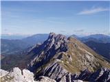
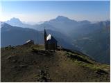
 | Vršič - Prisank / Prisojnik (Slovenian way)
Prisank (also known as Prisojnik) is a 2,547-meter-high mountain situated above the Mlinarica, Krnica, and Suha Pišnica valleys. From the summit,...
3 h 30 min |
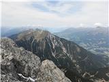
| Erjavčeva koča na Vršiču - Prisank / Prisojnik (Slovenska pot)
Prisank (also known as Prisojnik) is a 2,547-meter-high mountain situated above the Mlinarica, Krnica, and Suha Pišnica valleys. From the summit,...
3 h 45 min |
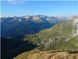
 | Planina Podvežak - Ojstrica (via Mala Ojstrica)
Ojstrica, named for its sharp shape, rises steeply above Korošica, the Logarska Dolina valley, and Robanov Kot. From the summit, which has a regi...
3 h 30 min |
 | Planina Pungrat - Veliko Kladivo
Veliko Kladivo is a 2094 m high peak in the longest Slovenian ridge, Košuta. From the summit, which has a register box and stamp, there is a very...
2 h 15 min |
 | D station - Velika Črnelska špica
Velika Črnelska špica is located in the Kanin mountains on the border between Italy and Slovenia. From the top there is a very nice view of the V...
3 h 35 min |
 | Jochalm - Reißkofel (235-1)
Reißkofel is a 2371 m high mountain in the Gailtal Alps. The summit, marked by a cross, also features a summit register. The view is particularly...
3 h |
 | Jochalm - Reißkofel (path 235)
Reißkofel is a 2371 m high mountain in the Gailtal Alps. The summit, marked by a cross, also features a summit register. The view is particularly...
3 h 25 min |
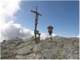 | Passo Falzarego - Lagazuoi Piccolo (via gallery)
Lagazuoi Piccolo is a 2,778 m high mountain located north of the Passo Falzarego pass (2,105 m). From the summit, where a cross stands, there is ...
2 h 15 min |
 | Plockenpass - Monte Floriz
Monte Floriz is a 2,184 m high grassy peak located south of the Marinelli hut. From the summit there is a very nice view of the Coglians group; i...
3 h |
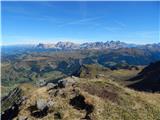 | Passo Pordoi - Belvedere (ridge way)
Belvedere is a 2,650-meter-high peak located north of Marmolada, the highest peak in the Dolomites. From the summit, where a small cross stands, ...
3 h |
 | Rifugio Valparola - Col di Lana (path 21)
Col di Lana (Italian: also Col di Sangue, 'bloody mountain') is a 2,452-meter-high mountain located west of the Valparola and Falzarego passes. O...
2 h 40 min |
 | Obertauern - Gamsleitenspitze (via Zehnerkar Sattel)
Gamsleitenspitze is a 2359-meter-high mountain in the Radstädter Tauern mountain group. From the summit, located above the Obertauern ski center,...
2 h 30 min |
 | Obertauern - Zehnerkarspitze
Zehnerkarspitze is a 2382-meter-high peak in the Radstädter Tauern group. The summit lies west of Obertauern pass above the ski center. From the ...
2 h 10 min |
 | Passo di Sant'Antonio - Monte Aiarnola (via normale)
Monte Aiarnola is a mountain at the far eastern end of the Sexten Dolomites group. From it there is a nice view towards the western Carnic Alps, ...
3 h 30 min |
 | Oberissalm - Vordere Sommerwand (normal path)
Sommerwand is a relatively long ridge rising as a massive rocky barrier above the upper part of the Oberbergtal valley, concealing from valley vi...
2 h 40 min |
 | Sella di Razzo - Clapsavon (via 210 & 212)
Clapsavon is a 2,462-meter-high mountain in the Carnic Alps in Italy. It lies about an hour's walk west of the 2,474-meter-high Bivera. Both peak...
3 h |