 | Komare doline - Lačna
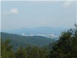
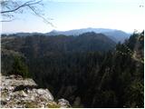
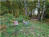
Lačna is a 451-meter-high hill located between Gračišče, Kubed, and Hrastovlje. The summit, which features a metal observation tower offering nic...
35 min |
 | Ljubljana (Spodnji Rudnik) - Orle
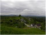
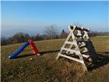
Orle is a settlement in the Municipality of Škofljica, located on a small hill northeast of the Ljubljana Marshes. A few meters below the highest...
40 min |
 | Stoperce - Sveta Ana above Stoperce
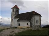
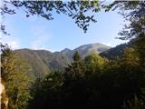
The Church of St. Anne is situated on a 460-meter-high hill rising west of the settlement Stoperce. From the church or its nearby surroundings, a...
40 min |
 | Suhadole - Koseški hrib (via Mlinčki)
Koseški hrib is located between Kuharjev boršt and Koseze, the settlement after which the peak is also named. From the summit, which has a table,...
50 min |
| Bukovica pri Vodicah - Koseški hrib (via Mlinčki)
Koseški hrib is located between Kuharjev boršt and Koseze, the settlement after which the peak is also named. From the summit, which has a table,...
50 min |
 | Topole - Koseški hrib
Koseški hrib is located between Kuharjev boršt and Koseze, the settlement after which the peak is also named. From the summit, which has a table,...
55 min |
 | Dragomer - Strmca (via Ferjanka)
Strmca is a lesser-known forested hill located between the settlements of Brezje pri Dobrovi and Log pri Brezovici. Due to the forest cover, ther...
45 min |
 | Kamnik - Sveta Ana (Tunjice)
The Baroque church of St. Ana in Tunjice is located on a hill west of Kamnik. Near the church is a summit register box, and slightly offside is t...
1 h |
 | Snack Bar Zelena dolina - Church of Our Lady of Loreto in Ložno
The Church of Our Lady of Loreto at Ložno stands on a panoramic hill northeast of Rogaška Slatina. A chapel and an NOB monument stand by the chur...
1 h 5 min |
| Brzika - Church of Our Lady of Loreto in Ložno
The Church of Our Lady of Loreto at Ložno stands on a panoramic hill northeast of Rogaška Slatina. A chapel and an NOB monument stand by the chur...
55 min |
 | Jezero - Sveta Ana
The Church of St. Ana is situated on a small panoramic hill above Jezero, Podpeč, and Preserje. From the top, which has a panorama board, a nice ...
35 min |
 | Bad Gleichenberg (Eichgraben Weg) - Mühlsteinbruch
Mühlsteinbruch lies north to northeast of Bad Gleichenberg. A cross stands on the summit, with the Edelweißwarte lookout tower and Enzian Hütte h...
35 min |
 | Rechnitz (Badesee) - Donatikappele (above Rechnitz)
The Chapel of St. Donatus is located on a small hill northwest of the settlement Rechnitz....
45 min |
 | Zazid - Kuk
Kuk (also known as Ščukovec on some maps) is a 498-meter-high hill north of the village Movraž. From the summit, which features a small cross, th...
1 h |
 | Škofja Loka - Divja Loka Castle (Stari grad)
Divja Loka Castle (also known as Stari grad) above Škofja Loka is located on a small hill north of Nemški grič. First mentioned in 1202, it was r...
40 min |
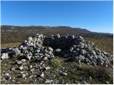 | Zazid - Veliki Gradež
Veliki Gradež is a 507-meter-high rise between Zazid and Movraž. From the summit, amid expansive pastures, there is a fine view of the Primorska ...
45 min |
 | Vrtovin - Školj Svetega Pavla above Vrtovin
Školj sv. Pavla is located on a panoramic hill above the village of Vrtovin, which lies west of Ajdovščina. From the church, near which the logbo...
35 min |
 | Dravograd lake - Church of the Holy Cross at Dravograd
The Church of the Holy Cross near Dravograd stands on a panoramic rise from which fine views extend over the western Pohorje, Slovenjgraška Basin...
45 min |
 | Velenje (Stari trg) - Malo Gradišče (on mountain trail)
Gradišče is a hill above Pesje near Velenje.It has two peaks: Veliko Gradišče and Malo Gradišče.Malo Gradišče lies east of the St. James church.T...
45 min |
 | Veliki Erjavec - Vodenica
Vodenica is a vast, forest-covered hill southwest of Ozalj. The summit is an HPO point and part of the Dubovačka planinska pot. The summit is par...
45 min |
| Vratca - Štanjel (Sveti Danijel) (Vratca - Sv. Danijel (Štanjel))
Štanjel (Sveti Danijel) is located east of Škabrijel (646 m). On the summit are remains of positions and trenches from World War I.On the summit ...
1 h |
 | Buzet Railway Station - Pilj (nad Buzetom)
Pilj is a grassy peak above Buzet. It is located on the edge of the cliff. From the summit, which has an inscription on the rock, a beautiful vie...
1 h |
 | Borovic (road on Hum) - Sveti Duh (Hum) (past Titova špilja)
Sveti Duh is a chapel located northeast of Hum, the highest peak on Vis island, though it is under military control and inaccessible. From the ch...
50 min |
 | Zreče (church of St. Egidij) - Sveti Martin (Zlakova) (on PP4)
The Church of St. Martin is situated on a panoramic hill on the edge of Zlakova village. From the church, a nice view opens up towards part of Po...
40 min |
 | Kamna Gorica - Lipnica Castle (Pusti grad above Lipnica)
Lipniški Castle, or Pusti grad above Lipnica (German: Waldenberg), is located on a panoramic hill above the Sava and Lipnica watercourses, more p...
40 min |
| Kamna Gorica - Lipnica Castle (Pusti grad above Lipnica) (via Galerije)
Lipniški Castle, or Pusti grad above Lipnica (German: Waldenberg), is located on a panoramic hill above the Sava and Lipnica watercourses, more p...
45 min |
 | Lovrenc na Pohorju (cemetery) - Hožičev vrh
Hožičev vrh is a 595-meter-high indistinct peak located southwest of the center of Lovrenc na Pohorju. At the summit, there is a small sign marki...
40 min |
 | Preval Prosca - Visoki hrib
Visoki hrib is a 602-meter-high hill located south of Polhov Gradec. From the summit, which is partly overgrown with forest, a beautiful view ope...
50 min |
 | Lokev - Stari tabor
Stari Tabor is a panoramic peak located west of Divača, north of Lokev, and south of the village of Povir. From the summit, which has a stamp and...
45 min |
 | Čatež - Bajturn (Zaplaški hrib) (on ridge)
Bajturn, or Zaplaški hrib, at 609 meters, is the highest peak in the Trebnje municipality. The summit features a pleasant bench with a table, a b...
40 min |
| Čatež - Bajturn (Zaplaški hrib) (on north slope)
Bajturn, or Zaplaški hrib, at 609 meters, is the highest peak in the Trebnje municipality. The summit features a pleasant bench with a table, a b...
50 min |
 | Aussichtswarte Vulkanland - Stradner Kogel
Stradner Kogel is the highest hill in southeastern Styria, Austria. The hill is of volcanic origin, and the summit offers no views in any directi...
45 min |
 | Pečar - Žagarski vrh
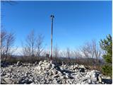
Žagarski vrh is situated on the ridge between Podlipoglav and Besnica. From the summit, where there is the amateur radio operators' hut, there is...
35 min |
 | Preddvor - Novi grad (Pusti grad)
Novi grad or Pusti grad (German: Neuburg) is first mentioned in 1156. Today, only ruins remain of the castle, which is located on a hill north to...
40 min |
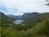 | Jezersko polje - Peč (viewpoint)
The viewpoint is located about 50 vertical meters below the 720-meter-high Peč peak, which separates the Lower from the Upper Bohinj Valley on th...
35 min |