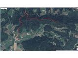
 | Kranj (Kalvarija) - Šmarjetna gora (partly on footpath)
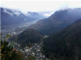
Šmarjetna gora is a panoramic peak rising above Kranj. From the summit, where the Church of St. Margaret and the Hotel Bellevue stand, a beautifu...
40 min |
| Kranj-Stražišče (Šrotenturn) - Šmarjetna gora (east path)
Šmarjetna gora is a panoramic peak rising above Kranj. From the summit, where the Church of St. Margaret and the Hotel Bellevue stand, a beautifu...
45 min |
 | Kranj-Stražišče (Šrotenturn) - Šmarjetna gora (west path)
Šmarjetna gora is a panoramic peak rising above Kranj. From the summit, where the Church of St. Margaret and the Hotel Bellevue stand, a beautifu...
40 min |
| Kranj-Stražišče (Šrotenturn) - Šmarjetna gora (by cart track)
Šmarjetna gora is a panoramic peak rising above Kranj. From the summit, where the Church of St. Margaret and the Hotel Bellevue stand, a beautifu...
45 min |
 | Tičnica - Šmarjetna gora
Šmarjetna gora is a panoramic peak rising above Kranj. From the summit, where the Church of St. Margaret and the Hotel Bellevue stand, a beautifu...
50 min |
 | Sora - Hom (steep past cemetery)
Hom is a 715 m high peak that rises steeply southwest of the village of Sora. From the summit, which is partly forested, there is a beautiful vie...
50 min |
 | Gradec - Osojnica
Osojnica is a forested hill located west of Pivka. The summit features a logbook box, stamp, and bench, but offers no views....
45 min |
 | Dobrič (Vedet) - Gora Oljka (by road)
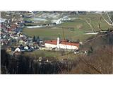
Gora Oljka is a hill located east of Šmartno ob Paki. On the summit stands the Church of the Holy Cross, built in the mid-18th century. Just a fe...
50 min |
 | Pogorelec - Sedlata gorica (Pogorelec)
Sedlata gorica is a peak above the village of Podturn pri Dolenjskih Toplicah. It used to be forested, but today a clearing on the summit is used...
45 min |
 | Lučine - Sivka
Sivka is a grassy peak at the far western end of Polhograjsko hribovje. On clear days, it offers breathtaking views from Snežnik across Javorniki...
50 min |
 | Koroška Bela - Malnež
Malnež is an 846-meter-high panoramic peak in the southern Karawanks, situated on the eastern side of the small valley where the village of Koroš...
40 min |
 | Kamnik - Visoka špica (direct way)
An indistinct but clearly visible forested hill above Kamnik from everywhere. Due to the slightly lower Čokl, on which Kamnik Castle stands, it i...
40 min |
 | Kamnik - Visoka špica (via Stari grad)
An indistinct but clearly visible forested hill above Kamnik from everywhere. Due to the slightly lower Čokl, on which Kamnik Castle stands, it i...
50 min |
 | Nemilje - Sveti Primož in Felicijan (Jamnik) (on marked path)
The Church of St. Primož and Felicijan at Jamnik is located on a scenic grassy ridge rising between Kropa and Podblica. From the church or its ne...
50 min |
 | Zgornja Besnica (Nova vas) - Rovnik (west path)
Rovnik is a 707-meter-high peak located west of Zgornja Besnica. The summit features two benches, a wish bell, and a logbook box, but offers no v...
40 min |
 | Zgornja Besnica (Nova vas) - Rovnik (east path)
Rovnik is a 707-meter-high peak located west of Zgornja Besnica. The summit features two benches, a wish bell, and a logbook box, but offers no v...
45 min |
 | Grad Hošperk - Stari grad
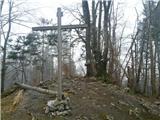
Stari grad is a 703-meter-high peak between Planina and Unec. From the summit, home to transmitters and obscured by forest and bushes, views are ...
40 min |
 | Čepovan (Želinc) - Vrh Skopice
Vrh Skopice, also known as Skopica, is a panoramic peak located between the Čepovan Valley, the Idrijca River valley, and the Trebuščica River va...
50 min |
 | Olševek - Apnišče (west path)
Apnišče is a 740 m high mountain between Možjanca and Štefanja gora. It is the highest point of the Šenčur municipality. The forested summit offe...
55 min |
 | Olševek - Apnišče (via Šterna)
Apnišče is a 740 m high mountain between Možjanca and Štefanja gora. It is the highest point of the Šenčur municipality. The forested summit offe...
55 min |
 | Podhom - Hom at Bled
Hom is an 834-meter-high hill rising north above the villages of Zasip and Podhom near Bled, or south of the village Blejska Dobrava near Jesenic...
40 min |
 | Rodik - Ajdovščina
Ajdovščina is an 804-meter-high peak located above Rodik and Slopami. A metal container stands on the overgrown summit today, and ruins of a form...
40 min |
 | Železniki - Hujska (via Kres)
Hujska is a 706-meter-high peak located above Železniki, more precisely between the Dašnjica and Češnjica streams. At the summit there is a bench...
45 min |
| Železniki - Hujska
Hujska is a 706-meter-high peak located above Železniki, more precisely between the Dašnjica and Češnjica streams. At the summit there is a bench...
40 min |
 | Škalske Cirkovce - Smodivnik
Smodivnik is a less-visited hill that rises on one side above the Huda luknja basin near Dolič and on the other above the Velenje Basin.The summi...
45 min |
 | Lovrenc na Pohorju (cemetery) - Koglerjev vrh
Koglerjev vrh is a 698-meter-high forested peak located southwest of the organic farm Šlaus-Kogler, which lies above the settlement of Lovrenc na...
45 min |
 | Slovenj Gradec - Rahtelov vrh (eastern path)
Rahtelov vrh is located north of Slovenj Gradec, above the left bank of the Mislinja River. On the summit there is a repeater facility and some t...
45 min |
| Slovenj Gradec - Rahtelov vrh (southeastern path)
Rahtelov vrh is located north of Slovenj Gradec, above the left bank of the Mislinja River. On the summit there is a repeater facility and some t...
45 min |
 | Škalnica - Pliševica (Way of the Cross)
Pliševica is a panoramic grassy summit above Škalnica, near the Slovenian border. From the top, marked by a concrete stone with a logbox, beautif...
50 min |