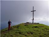
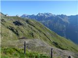
 | Eisenkappler Hutte - Hochobir (Ojstrc)
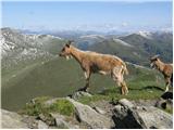
Ojstrc (Hochobir) is the highest peak of the smaller Obir range. It is located west of Železna Kapla (Eisenkappel) on the Austrian side of the Ka...
1 h 35 min |
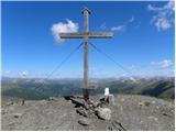
 | Winterleiten parking - Zirbitzkogel
Zirbitzkogel, at 2,396 m, is the highest peak of the Labotniške Alpe / Seetaler Alpen. From the summit, where a cross and a panorama board stand,...
2 h 17 min |
 | Tonnerhütte - Fuchskogel
Fuchskogel is a peak south of Zirbitzkogel in the Seetaler Alpen mountain group. The summit is broad and mostly covered in grass. More precisely,...
2 h 20 min |
 | Winterleiten parking - Scharfes Eck
Scharfes Eck is a peak on which stands an Austrian meteorological radar station. From the summit, there is a beautiful view of the neighbouring p...
2 h |
 | Walischeben - Weißenstein (Packalpe) (Direct way)
Weißenstein is a grassy mountain crisscrossed with wire fences. From its indistinct summit, there is a nice view of the neighboring Ameringkogel ...
1 h 45 min |
 | Salzstiegelhaus - Weißenstein (Packalpe)
Weißenstein is a grassy mountain crisscrossed with wire fences. From its indistinct summit, there is a nice view of the neighboring Ameringkogel ...
2 h 20 min |
 | Walischeben - Ameringkogel (Packalpe) (Direct way)
Ameringkogel is a grassy summit with a cross and summit register. At 2,187 meters, it is the highest peak of the Packalpe. In good visibility, th...
1 h 55 min |
| Salzstiegelhaus - Ameringkogel (Packalpe)
Ameringkogel is a grassy summit with a cross and summit register. At 2,187 meters, it is the highest peak of the Packalpe. In good visibility, th...
2 h 30 min |
 | Walischeben - Großenberg (Packalpe) (via Ameringkogel)
Großenberg, also known as Größing, is the northernmost two-thousander in the Packalpe mountain group. From its expansive grassy summit, where a t...
2 h 25 min |
| Walischeben - Großenberg (Packalpe) (below the Ameringkogel summit)
Großenberg, also known as Größing, is the northernmost two-thousander in the Packalpe mountain group. From its expansive grassy summit, where a t...
2 h 20 min |
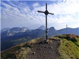
 | Plattner - Gartnerkofel (via Watschiger Alm)
Gartnerkofel is a 2,195-meter-high mountain in the Nassfeld ski area. Its Slovenian name is Krniške skale. From the summit, where a cross stands,...
2 h |
 | Rosstratte - Dobratsch / Dobrač (by road)
Dobrač, or in German Dobratsch and also known as Villacher Alpen, is a 2166-meter-high mountain situated on the far eastern edge of the Gailtal A...
2 h |
 | Smučišče Koralpe (Koralpenparkplatz) - Großer Speikkogel (Koralpe)
Großer Speikkogel is, at 2,140 meters, the highest peak of Golica/Koralpe, a range east of Volšperk/Wolfsberg. From the summit, where a cross and...
1 h 35 min |
 | Smučišče Koralpe (Koralpenparkplatz) - Großer Speikkogel (Koralpe) (by the edge of the Großes Kar plateau)
Großer Speikkogel is, at 2,140 meters, the highest peak of Golica/Koralpe, a range east of Volšperk/Wolfsberg. From the summit, where a cross and...
2 h 15 min |
 | Turracher Höhe - Rinsennock (northern way)
Rinsennock is a 2,334 m high peak located in the heart of the Gurktal Alps. From the summit, where a cross stands, there are fine views ranging f...
1 h 45 min |
| Turracher Höhe - Rinsennock (southern way)
Rinsennock is a 2,334 m high peak located in the heart of the Gurktal Alps. From the summit, where a cross stands, there are fine views ranging f...
1 h 45 min |
 | Heidi Alm - Klomnock
Klomnock is the house mountain of the Nockalmstraße alpine road, leading to the Schiestelscharte pass (2,024 m). From the summit, where a cross s...
2 h 15 min |
 | Turracher Höhe - Gruft
Gruft is a grass-covered peak located southeast of the Turracher Höhe pass in the heart of the Gurktal Alps. From its 2,232 m high summit there a...
1 h 45 min |
 | Turracher Höhe - Kaserhöhe
Kaserhöhe is a panoramic peak located in Austrian Carinthia in the heart of the Gurktal Alps. On the spacious summit, which is partly covered in ...
2 h 20 min |
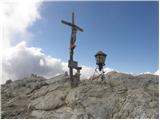 | Passo Falzarego - Lagazuoi Piccolo (normal way)
Lagazuoi Piccolo is a 2,778 m high mountain located north of the Passo Falzarego pass (2,105 m). From the summit, where a cross stands, there is ...
2 h 15 min |
 | Rifugio Auronzo - Croda Fiscalina di Mezzo / Oberbachernspitze
Croda Fiscalina di Mezzo, or in German Oberbachernspitze, is a 2675-meter-high mountain located in the heart of the Dolomiti di Sesto / Sextner D...
2 h 30 min |
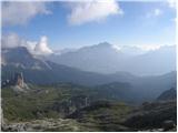 | Passo Falzarego - Rifugio Nuvolau
The mountain hut Rifugio Nuvolau is located on its eponymous summit, southwest of Cortina d'Ampezzo. On clear days, it offers a breathtaking pano...
2 h 15 min |
 | Rifugio Bai de Dones - Rifugio Nuvolau (via Rifugio Cinque Torri)
The mountain hut Rifugio Nuvolau is located on its eponymous summit, southwest of Cortina d'Ampezzo. On clear days, it offers a breathtaking pano...
2 h 35 min |
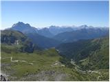
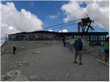 | Passo Pordoi - Sass de Pordoi
Sass de Pordoi is a 2,950-meter-high peak located north of the Passo Pordoi alpine pass. The Rifugio Maria mountain hut stands on the summit, rea...
2 h |
 | Rifugio Selvapiana I.Lunelli - Croda Sora I Colesei / Arzalpenkopf (via Forcella Popera)
Croda Sora I Colesei (German: Arzalpenkopf) is a 2,321-meter-high mountain on the eastern edge of the Sexten Dolomites (Dolomiti di Sesto). The s...
2 h 30 min |
| Rifugio Selvapiana I.Lunelli - Croda Sora I Colesei / Arzalpenkopf (via Belvedere)
Croda Sora I Colesei (German: Arzalpenkopf) is a 2,321-meter-high mountain on the eastern edge of the Sexten Dolomites (Dolomiti di Sesto). The s...
2 h 30 min |
 | Heidi Alm - Schwarzkofel (ridge path)
Schwarzkofel is a 2168 m high peak located south of the Heidialm pasture. From the summit, where a small cross stands, a fine panorama opens up o...
2 h |
| Heidi Alm - Schwarzkofel (via Falkertscharte)
Schwarzkofel is a 2168 m high peak located south of the Heidialm pasture. From the summit, where a small cross stands, a fine panorama opens up o...
2 h 5 min |
 | Heidi Alm - Rodresnock (ridge path)
Rodresnock is a 2310 m high mountain rising southwest of Lake Falkertsee. From the summit, where a large cairn stands with a cross in its center,...
1 h 30 min |
 | Heidi Alm - Rodresnock (via Falkertscharte)
Rodresnock is a 2310 m high mountain rising southwest of Lake Falkertsee. From the summit, where a large cairn stands with a cross in its center,...
1 h 30 min |
 | Heidi Alm - Falkert (via Falkertscharte)
Falkert is a 2308 m high peak located west of the village and Lake Falkertsee. From the summit, which has a few benches, a summit logbox with sta...
1 h 30 min |
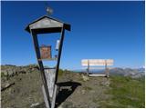 | Heidi Alm - Falkert (via Hundsfeldscharte)
Falkert is a 2308 m high peak located west of the village and Lake Falkertsee. From the summit, which has a few benches, a summit logbox with sta...
1 h 30 min |
 | Heidi Alm - Mallnock
Mallnock is a 2226 m high peak located north of the settlement St. Oswald in the Krške Alpe. From the summit, where a cross stands, a beautiful v...
2 h 30 min |
 | Rifugio Rio Gere - Rifugio Tondi
Rifugio Tondi is situated a few meters below the summit of Monte Ciasadio, the highest point of the Faloria ski slope. From the hut, there is a v...
2 h 15 min |
 | Rifugio Valparola - Setsas
The Setsas peak is located west of the Passo Valparola pass and is somewhat distant from the highest summits. Precisely because of this remotenes...
2 h 30 min |
 | Zettersfeld - Goiselemandl
Goiselemandl is a 2,433-meter-high peak in the Schober mountain group. The mountain is fairly well-visited due to its proximity to the cable car....
1 h 30 min |
 | Obertauern - Gamsleitenspitze
Gamsleitenspitze is a 2359-meter-high mountain in the Radstädter Tauern mountain group. From the summit, located above the Obertauern ski center,...
2 h |
 | Malga Crocifisso - Col de Valvacin
Col de Valvacin is a 2,372-meter-high peak on the west side of the Marmolada group near the Buffaure ski slopes. Rifugio el Zedron mountain hut i...
2 h 15 min |
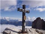
 | Rifugio Fedare - Monte Pore
Monte Pore or Spiz de Poure is a 2,405-meter-high grassy peak located west of the Averau and Nuvolau summits. From the top, where a large cross s...
1 h 30 min |