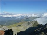
 | Valvasorjev dom pod Stolom - Hochstuhl/Stol (Zabreška way)
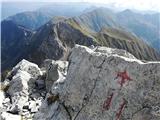
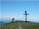
Stol is, at 2,236 m, the highest peak in the Karawanks. From the summit, which has a registration box and stamp, a beautiful view opens onto the ...
3 h 20 min |
 | Valvasorjev dom pod Stolom - Hochstuhl/Stol (Žirovniška way)
Stol is, at 2,236 m, the highest peak in the Karawanks. From the summit, which has a registration box and stamp, a beautiful view opens onto the ...
3 h |
 | Tinčkova koča - Hochstuhl/Stol (via Smokuška planina)
Stol is, at 2,236 m, the highest peak in the Karawanks. From the summit, which has a registration box and stamp, a beautiful view opens onto the ...
4 h 15 min |
 | Razpotje Vragovec - Hochstuhl/Stol (via Zabreška planina)
Stol is, at 2,236 m, the highest peak in the Karawanks. From the summit, which has a registration box and stamp, a beautiful view opens onto the ...
3 h |
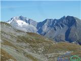
 | Kriška planina - Kalški greben (via planina Koren)
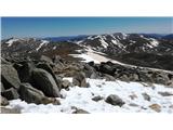
Kalški greben is a 2224 m high peak and the highest point of the ridge bearing the same name. From the summit, where there is a summit register a...
3 h 45 min |
| Dom na Gospincu - Kalški greben (via Dolga Njiva)
Kalški greben is a 2224 m high peak and the highest point of the ridge bearing the same name. From the summit, where there is a summit register a...
3 h 20 min |
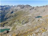
| Planina Jezerca - Kalški greben (via planina Koren)
Kalški greben is a 2224 m high peak and the highest point of the ridge bearing the same name. From the summit, where there is a summit register a...
4 h |
 | Waldheimhütte - Scharfes Eck
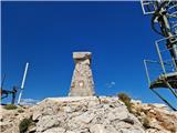
Scharfes Eck is a 2364-meter-high peak in the Austrian mountain range Labotniške Alpe (Seetaler Alpe). A prominent Austrian meteorological radar ...
2 h 45 min |
 | Etrachsee - Bauleiteck
Bauleiteck is a panoramic peak located on the eastern part of the Schladminger Tauern mountain group. From the summit, where a cross stands, ther...
3 h 15 min |
 | Piano Fiscalino / Fischleinboden - Croda Fiscalina di Mezzo / Oberbachernspitze
Croda Fiscalina di Mezzo, or in German Oberbachernspitze, is a 2675-meter-high mountain located in the heart of the Dolomiti di Sesto / Sextner D...
4 h |
 | Volkzeinalm - Hochalmspitze (Villgraten)
Hochalmspitze is a 2797-meter-high peak located in the southwestern part of the High Tauern in the Villgraten mountain group. This peak is much l...
2 h 45 min |
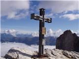
 | Plockenpass - Creta di Collinetta / Cellon
Creta di Collinetta / Cellon is a 2,238-meter-high mountain located west of the Plöcken Pass. From the summit, which features a cross, there is a...
3 h |
 | Piano Fiscalino / Fischleinboden - Sasso di Sesto / Sextnerstein
Sasso di Sesto is a 2,539-meter-high peak located in the Sexten Dolomites Nature Park. This easily accessible peak offers exceptional views of th...
3 h 30 min |
 | Colfosco - Sas Ciampac
Sas Ciampac is a 2672-meter-high peak in the Puez group. From the summit, which features a small wooden cross, there is a nice view of the Puez g...
3 h 30 min |
 | Sadnighaus - Sadnig (direct way (path 150))
Sadnig or Hoher Sadnig is a relatively easily accessible and panoramic mountain in the eponymous Sadnig group (German: Sadniggruppe), the souther...
2 h 45 min |
 | Sadnighaus - Sadnig (via mountain pasture Lindler (pot 149))
Sadnig or Hoher Sadnig is a relatively easily accessible and panoramic mountain in the eponymous Sadnig group (German: Sadniggruppe), the souther...
3 h 15 min |
 | Sportgastein - Greilkopf (via Hagener Hütte)
Greilkopf is a 2,581 m high mountain in the Ankogel group of the Hohe Tauern in Austria above the town of Mallnitz. It is a popular winter destin...
3 h 45 min |
 | Parking below Jamnigalm - Feldseekopf (via Feldseecharte)
Feldseekopf, at 2,864 m, is as high as Triglav. The mountain is located in the Goldberg group of the Hohe Tauern in Austria and receives far fewe...
3 h 50 min |
 | Plöckenhaus - Polinik (path 403)
Polinik is a 2,332-meter-high mountain in the Austrian part of the Carnic Alps near the mountain pass to Italy, the Plöckenpass.East of Polinik l...
3 h 15 min |
 | Turrach - Eisenhut
Eisenhut, at 2,441 meters, is the highest peak in the Gurktal Alps, which stretch across the basin of the Krka/Gurk River and descend to the nort...
4 h 30 min |
 | Turrach - Straßburger Spitz
Straßburger Spitz is a 2,404-meter-high peak located between the summits of Eisenhut (2,441 m) and Wintertalernock (2,394 m). From the top, where...
4 h |
 | Turrach - Wintertalernock
Wintertalernock is a 2,394-meter-high peak located southeast of the highest summit of the Gurktal Alps, Eisenhut. From the top, where a cross sta...
4 h 15 min |
 | Thredbo - Mount Kosciuszko (Merritts Track & Mt. Kosciuszko Track)
Mount Kosciuszko is the highest mountain on mainland Australia, the easiest of the elite "Seven Summits", and it is also on the Ultra list. The m...
4 h |
 | Passo San Pellegrino - Cima Juribrutto
Cima Juribrutto is a 2,697-meter-high mountain rising above the San Pellegrino Pass. It offers a nice view also towards the Valles Pass....
3 h |
 | Nida - Timios Stavros / Psiloritis (Kreta)
Timios Stavros is Crete's highest mountain at 2,456 meters and also the highest among the Greek islands. Due to its topographic prominence, it is...
4 h 15 min |
 | Lakkos tou Mygerou - Timios Stavros / Psiloritis (Kreta)
Timios Stavros is Crete's highest mountain at 2,456 meters and also the highest among the Greek islands. Due to its topographic prominence, it is...
3 h |
 | Masna Luka - Pločno
Pločno is the highest peak of the Čvrsnica range and the fourth highest peak in Bosnia and Herzegovina. At its highest point is a geodetic pillar...
4 h 30 min |