 | Topol - Jeterbenk
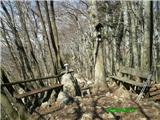
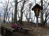
Jeterbenk is a 774-meter-high peak located between the Slavkov dom hut on Golo Brdo and Katarina (the village of Topol). From the summit, where t...
45 min |
 | Praproče - Mali vrh
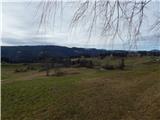
West of Polhov Gradec, between the rivers Mala voda and Velika Božna, lies the 708-meter-high hill known as Mali vrh. From the grassy summit, whi...
35 min |
 | Zaplana (St. Urh and St. Martin) - Koča na Planini nad Vrhniko
Planina nad Vrhniko is for Vrhnika locals something like Šmarna gora for those from Ljubljana. It is 733 m high, reachable by several paths from ...
45 min |
 | Zagreben (pri Dikcu) - Dom na Šmohorju
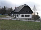
The mountain lodge on Šmohor is located on a picturesque and scenic ridge between Laško, Liboje and Zabukovica. The lodge, a popular spot for bot...
45 min |
 | Sveta Gora - Vodice
Vodice (according to some records also Sveti Jakob) is a peak on the western part of the Banjška planota plateau. From the summit, which features...
45 min |
 | Tržič - Sveti Jurij above Tržič
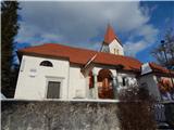
The Church of St. Jurij, built in the 15th century, stands on a small hill above Tržič or Bistrica pri Tržiču. Nearby Gutenberg Castle, to which ...
40 min |
 | Veliko Trebeljevo - Kucelj
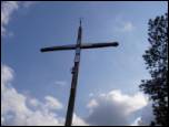
Kucelj is a 748-meter-high peak situated north of Višnja gora. From the summit, where there is a small geodetic tower with a nearby stamp, there ...
45 min |
 | Lokev - Stari tabor
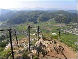
Stari Tabor is a panoramic peak located west of Divača, north of Lokev, and south of the village of Povir. From the summit, which has a stamp and...
45 min |
 | Križevska vas - Murovica (circular path)
Murovica is a popular excursion point, accessible from the Posavje side, Domžale, or the Moravška Valley. On the summit there is a bench and a lo...
50 min |
 | Križevska vas - Murovica
Murovica is a popular excursion point, accessible from the Posavje side, Domžale, or the Moravška Valley. On the summit there is a bench and a lo...
45 min |
 | Trebež (Jesenice) - Kozjek (on east ridge)
Kozjek is a 766 m high, easily accessible ridge-like secondary peak of Jelenkamen, belonging to the southern Karawanks foothills; it is located a...
30 min |
 | Vinska Gora - Gonžarjeva peč (easy path)
Gonžarjeva peč, increasingly known in recent times due to a new climbing route, is located on a hill northwest of Vinska Gora. At the summit of G...
30 min |
 | Gaber pri Semiču - Smuk (via Smuška cesta)
Smuk is a 545-meter-high peak above Semič. The summit features the Church of St. Lawrence, a hunting cabin, and nearby ruins of Smuk (or Turn) Ca...
50 min |
 | Žusem Castle - Žusem
Žusem is a 669-meter-high hill with a rich history and great potential for the future. It forms the northern edge of Kozjansko, and its name deri...
30 min |
 | Govejk - Sveti Tomaž (Vrsnik nad Žirmi)
The Church of St. Tomaž is located on a scenic elevation between the hamlets of Spodnji and Gornji Vrsnik. From the church opens a nice view of b...
40 min |
 | Zaplaz - Bajturn (Zaplaški hrib) (on north slope)
Bajturn, or Zaplaški hrib, at 609 meters, is the highest peak in the Trebnje municipality. The summit features a pleasant bench with a table, a b...
30 min |
| Čatež - Bajturn (Zaplaški hrib) (on ridge)
Bajturn, or Zaplaški hrib, at 609 meters, is the highest peak in the Trebnje municipality. The summit features a pleasant bench with a table, a b...
40 min |
 | Kamna Gorica - Lipnica Castle (Pusti grad above Lipnica)
Lipniški Castle, or Pusti grad above Lipnica (German: Waldenberg), is located on a panoramic hill above the Sava and Lipnica watercourses, more p...
40 min |
| Kamna Gorica - Lipnica Castle (Pusti grad above Lipnica) (via Galerije)
Lipniški Castle, or Pusti grad above Lipnica (German: Waldenberg), is located on a panoramic hill above the Sava and Lipnica watercourses, more p...
45 min |
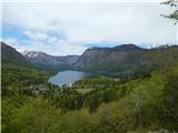 | Jezersko polje - Peč (viewpoint)
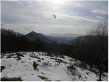
The viewpoint is located about 50 vertical meters below the 720-meter-high Peč peak, which separates the Lower from the Upper Bohinj Valley on th...
35 min |
 | Pečar - Žagarski vrh
Žagarski vrh is situated on the ridge between Podlipoglav and Besnica. From the summit, where there is the amateur radio operators' hut, there is...
35 min |
 | Aussichtswarte Vulkanland - Stradner Kogel
Stradner Kogel is the highest hill in southeastern Styria, Austria. The hill is of volcanic origin, and the summit offers no views in any directi...
45 min |
 | Velenje (Stari trg) - Malo Gradišče (on mountain trail)
Gradišče is a hill above Pesje near Velenje.It has two peaks: Veliko Gradišče and Malo Gradišče.Malo Gradišče lies east of the St. James church.T...
45 min |
 | Lovrenc na Pohorju (cemetery) - Hožičev vrh
Hožičev vrh is a 595-meter-high indistinct peak located southwest of the center of Lovrenc na Pohorju. At the summit, there is a small sign marki...
40 min |
 | Planina pri Sevnici - Sveti Križ (above Planina pri Sevnici) (via Pravljični gozd)
The Church of the Holy Cross is located above Planina pri Sevnici, near the settlement of Šentvid pri Planini. From the summit opens a fine view ...
28 min |
 | Račja vas - Marećica
Marećica is a lesser-known peak located above Buzet. The peak marks a point on the Obiteljska staza Marećica trail. From the summit, there is a b...
30 min |
 | Rašpor - Vrtelj
Vrtelj is an indistinct, forest-covered peak located on the Obiteljska staza Marećica path between Kosmatica and Vidikovec Prapoće....
35 min |