 | end of road on Pokljuka - Triglav (via Kredarica)
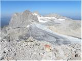
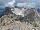
Triglav is a 2,864 m high mountain located in the heart of the Julian Alps. At this altitude, it is the highest mountain in Slovenia and also the...
6 h 15 min |
| end of road on Pokljuka - Triglav (via Planika and Mali Triglav)
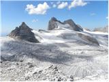
Triglav is a 2,864 m high mountain located in the heart of the Julian Alps. At this altitude, it is the highest mountain in Slovenia and also the...
6 h |
 | Uskovnica (Razpotje) - Triglav (via Triglavska škrbina)
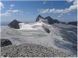
Triglav is a 2,864 m high mountain located in the heart of the Julian Alps. At this altitude, it is the highest mountain in Slovenia and also the...
6 h 25 min |
| end of road on Pokljuka - Triglav (via Planika and Triglavska škrbina)
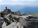
Triglav is a 2,864 m high mountain located in the heart of the Julian Alps. At this altitude, it is the highest mountain in Slovenia and also the...
5 h 55 min |
| Rudno polje - Triglav (past Dom Planika and Triglavska škrbina)
Triglav is a 2,864 m high mountain located in the heart of the Julian Alps. At this altitude, it is the highest mountain in Slovenia and also the...
6 h 20 min |
 | Rudno polje - Mali Triglav (via Dom Planika)
Mali Triglav is an indistinct summit on the main ridge of Triglav. Despite its considerable height, it is rarely chosen as an independent objecti...
5 h 50 min |
| Rudno polje - Mali Triglav (via Kredarica)
Mali Triglav is an indistinct summit on the main ridge of Triglav. Despite its considerable height, it is rarely chosen as an independent objecti...
6 h 5 min |
| end of road on Pokljuka - Mali Triglav (via Planika)
Mali Triglav is an indistinct summit on the main ridge of Triglav. Despite its considerable height, it is rarely chosen as an independent objecti...
5 h 25 min |
| end of road on Pokljuka - Mali Triglav (via Kredarica)
Mali Triglav is an indistinct summit on the main ridge of Triglav. Despite its considerable height, it is rarely chosen as an independent objecti...
5 h 40 min |
| Uskovnica (Razpotje) - Mali Triglav (via Planika)
Mali Triglav is an indistinct summit on the main ridge of Triglav. Despite its considerable height, it is rarely chosen as an independent objecti...
5 h 55 min |
 | Sella Nevea - Visoki Kanin (Via ferrata Rosalba Grasselli)
Visoki Kanin is the highest peak of the Kanin mountains. From the summit, which has a cross, there is a nice view of the western Julian Alps, and...
6 h 15 min |
 | Sella Nevea - Visoki Kanin (Via ferrata Divisione Julia)
Visoki Kanin is the highest peak of the Kanin mountains. From the summit, which has a cross, there is a nice view of the western Julian Alps, and...
4 h 45 min |
 | End of road on Pokljuka - Rjavina
Rjavina is located between two alpine valleys, Kot and Krma. From the summit, which has a logbook, there is a very nice view towards Triglav, Rž,...
6 h 25 min |
| Rudno polje - Rjavina
Rjavina is located between two alpine valleys, Kot and Krma. From the summit, which has a logbook, there is a very nice view towards Triglav, Rž,...
6 h 50 min |
 | Ski hotel Vogel - Vrh nad Škrbino
Vrh nad Škrbino is the easternmost two-thousander in the ridge of the Lower Bohinj Mountains. From the summit, there are excellent views of the n...
4 h 50 min |
 | Pecol - Cima di Terrarossa (Leva)
Špik Hude police is a 2431-meter-high panoramic peak (new LiDAR measurement; this height will also be shown on newer maps, while older maps still...
4 h 30 min |
 | Sella Nevea - Foronon del Buinz / Špik nad Nosom (via Forcella Lavinal dell Orso)
Špik nad Nosom is a 2,531 m high mountain located in the ridge between Montaž and Viš. From its rocky summit on a clear day, views open up to the...
6 h |
 | Sella Nevea - Vrh Krnice
Vrh Krnice is a 2,441-meter-high peak located northwest of Visoki Kanin. From the summit, where there is usually an empty logbook box, there is a...
5 h 15 min |
 | Parking Erichhütte - Hoher Kopf (path 432)
Hoher Kopf is located in the Berchtesgaden Alps, west of the highest peak, Höchkonig. The summit is popular mainly due to the protected climbing ...
4 h 45 min |
 | Türlwandhütte - Kleiner Koppenkarstein (via Hunerscharte)
Kleiner Koppenkarstein is a 2,832-meter peak in the Dachstein mountain group. This indistinct summit is located on the Koppenkarstein ridge above...
4 h 15 min |
 | Türlwandhütte - Großer Koppenkarstein (via Hunerscharte)
Großer Koppenkarstein is a 2865-meter-high mountain in the Dachstein mountain group. It is situated above the Schladminger Gletscher glacier. Fro...
4 h 50 min |
 | Türlwandhütte - Hoher Dachstein (via Hunerscharte)
Hoher Dachstein is, at 2995 meters, the highest peak of the Dachstein mountain group. The summit is located on the border between the federal sta...
5 h 45 min |
 | Parkplatz Erichhütte - Hochkönig (path 432)
Hochkönig is, at 2941 meters, the highest peak of the Berchtesgaden Alps. The peak, on which the Matrashaus mountain hut stands, is very well vis...
5 h 20 min |
 | Türlwandhütte - Kleiner Gjaidstein (via Hunerscharte)
Kleiner Gjaidstein is a 2735-meter-high peak in the Dachstein mountain group. The summit is situated on the ridge between the glaciers Schladming...
4 h 30 min |
 | Türlwandhütte - Hoher Gjaidstein (via Hunerscharte)
Hoher Gjaidstein is a 2792-meter-high peak in the Dachstein mountain group. The summit is situated on the ridge between glaciers Schladminger Gle...
5 h |
 | Alba di Canazei - Cima Ombretta (Via Ferrata Ombretta)
Cima Ombretta is a 3,011-meter-high peak in the Marmolada mountain group. From the summit, where a cross stands, there is the finest view of the ...
5 h 15 min |
 | Rifugio Pederü - Sasso delle Dieci / Zehnerspitze (path 12)
Sasso delle Dieci / Zehnerspitze is a 3,028-meter-high mountain rising steeply above Val Badia valley. Sasso delle Dieci is the highest peak in t...
5 h 30 min |
| Rifugio Pederü - Sasso delle Dieci / Zehnerspitze (path 7)
Sasso delle Dieci / Zehnerspitze is a 3,028-meter-high mountain rising steeply above Val Badia valley. Sasso delle Dieci is the highest peak in t...
5 h 35 min |
 | Ristorante Pietofana - Cima Formenton (via Rifugio Pomedes)
Cima Formenton is a 2,830-meter-high peak in the Tofana group. The mountain lies north of the better-known Tofana di Dentro, with an unmarked tra...
5 h 5 min |
 | Zettersfeld - Schleinitz (Klettersteig)
Schleinitz is a 2,905-meter-high peak in the southern part of the Schober mountain group. From the summit there is a very nice view of all the ma...
4 h 30 min |
 | Lenzanger - Goldzechkopf (via Hoher Sonnblick)
Goldzechkopf is a 3042-meter-high peak in the Goldberg mountain group. The summit is located on the ridge between the better-known Hoher Sonnblic...
6 h 10 min |
 | Obermoos - Zugspitze (Stopselziehersteig)
Zugspitze, at 2,962 meters, is the highest peak of the Wetterstein group and also Germany's highest mountain. It lies south of Garmisch-Partenkir...
5 h |
 | Passo di Costalunga / Karerpass - Roda di Vael / Rotwand (Via Ferrata Majare)
Roda di Vael (German: Rotwand) is a 2,806-meter-high mountain in the Catinaccio (Rosengarten) group. The mountain is recognizable mainly by its s...
5 h 30 min |
 | Piano Fiscalino / Fischleinboden - Croda Rossa di Sesto (Via Ferrata Croda Rossa)
Croda Rossa di Sesto (German: Sextner Rotwand, also Zehner) is a 2,965-meter-high mountain in the Sexten Dolomites (Dolomiti di Sesto). The mount...
5 h |
 | Plockenpass - Pilastro del Coglians
Pilastro del Coglians is a 2,750-metre peak east of Monte Coglians on the Austria-Italy border. A summit logbook is located on the compact summit...
4 h 30 min |
 | Rifugio Padova - Cima Montanel (via Forcella di Crodon)
Cima Montanel is a 2,461-meter-high peak above the Piave river valley in the Carnic Prealps. The summit, which bears a cross, is an exceptional v...
4 h 50 min |
 | Rifugio Pederü - Cima Nove / Neunerspitze
The Italian Cima Nove or Sasso delle Nove, German Neuner or Neunerspitze, Ladin Sas dles Nü or Nönör is a 2,968-meter-high peak in the Fanes-Sene...
4 h 50 min |
 | Plöckenpass - Creta della Chianevate / Kellerspitzen (path 171)
Creta della Chianevate (German: Kellerspitzen) is a 2,769-meter peak in the central Carnic Alps on the AustriaItaly border. From the summit, mark...
4 h 50 min |
| Plöckenpass - Creta della Chianevate / Kellerspitzen (via Cresta Verde)
Creta della Chianevate (German: Kellerspitzen) is a 2,769-meter peak in the central Carnic Alps on the AustriaItaly border. From the summit, mark...
5 h |
 | Capanna Alpina - Vallon Bianco
Vallon Bianco (Ladin: Valun Blanch) is a 2,688-meter peak above the Valle di Fanes and Val Travenanzes valleys. From the summit, which has a smal...
4 h 20 min |
| Sant'Uberto - Vallon Bianco
Vallon Bianco (Ladin: Valun Blanch) is a 2,688-meter peak above the Valle di Fanes and Val Travenanzes valleys. From the summit, which has a smal...
5 h 5 min |
| Rifugio Pederü - Vallon Bianco
Vallon Bianco (Ladin: Valun Blanch) is a 2,688-meter peak above the Valle di Fanes and Val Travenanzes valleys. From the summit, which has a smal...
4 h 40 min |
 | Capanna Alpina - Furcia Rossa III
Furcia Rossa III is a 2,791-meter-high peak in a somewhat more remote ridge along which the Walk of Peace (Fridensweg / Via della Pace) runs. At ...
4 h 30 min |
| Rifugio Pederü - Furcia Rossa III
Furcia Rossa III is a 2,791-meter-high peak in a somewhat more remote ridge along which the Walk of Peace (Fridensweg / Via della Pace) runs. At ...
4 h 50 min |
| Sant'Uberto - Furcia Rossa III
Furcia Rossa III is a 2,791-meter-high peak in a somewhat more remote ridge along which the Walk of Peace (Fridensweg / Via della Pace) runs. At ...
5 h 15 min |
 | parking lot Stupfer in Gaistal - Hohe Munde - western peak (on climbing path via western ridge)
Hohe Munde is a peak in the Mieming range west of Innsbruck and the local mountain of the town of Telfs, appearing as an imposing rock fortress a...
6 h 15 min |