 | Kranj (Kalvarija) - Šmarjetna gora (partly on footpath)
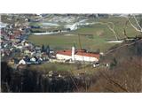
Šmarjetna gora is a panoramic peak rising above Kranj. From the summit, where the Church of St. Margaret and the Hotel Bellevue stand, a beautifu...
40 min |
| Kranj-Stražišče (Šrotenturn) - Šmarjetna gora (east path)
Šmarjetna gora is a panoramic peak rising above Kranj. From the summit, where the Church of St. Margaret and the Hotel Bellevue stand, a beautifu...
45 min |
 | Kranj-Stražišče (Šrotenturn) - Šmarjetna gora (west path)
Šmarjetna gora is a panoramic peak rising above Kranj. From the summit, where the Church of St. Margaret and the Hotel Bellevue stand, a beautifu...
40 min |
| Kranj-Stražišče (Šrotenturn) - Šmarjetna gora (by cart track)
Šmarjetna gora is a panoramic peak rising above Kranj. From the summit, where the Church of St. Margaret and the Hotel Bellevue stand, a beautifu...
45 min |
 | Strmica - Toško Čelo (via Brezarjevo brezno)
Toško Čelo is a 590-metre hill above the village of the same name. From the summit, or slightly below it, a beautiful view opens over part of Lju...
45 min |
 | Ribnik - Debenji vrh
Debenji vrh, also known as Debni or Deben vrh, at 530 m, is the highest peak of Kašeljski grič, a small range located between the Besnica valley ...
40 min |
 | Kamnik - Visoka špica (direct way)
An indistinct but clearly visible forested hill above Kamnik from everywhere. Due to the slightly lower Čokl, on which Kamnik Castle stands, it i...
40 min |
 | Povodje - Veliki vrh (Rašica)
Veliki vrh is a 568-meter-high hill located west of Vrh Staneta Kosca. Just a few meters below the otherwise forested summit lies a small abyss n...
45 min |
 | Hraše - Smledniški hrib (Stari grad)
Stari grad (also known as Smlednik Castle) is located on a small hill southwest of Valburga. In recent years, the castle has been renovated and n...
45 min |
 | Zgornja Besnica (Nova vas) - Rovnik (west path)
Rovnik is a 707-meter-high peak located west of Zgornja Besnica. The summit features two benches, a wish bell, and a logbook box, but offers no v...
40 min |
 | Zgornja Besnica (Nova vas) - Rovnik (east path)
Rovnik is a 707-meter-high peak located west of Zgornja Besnica. The summit features two benches, a wish bell, and a logbook box, but offers no v...
45 min |
 | Grad Hošperk - Stari grad
Stari grad is a 703-meter-high peak between Planina and Unec. From the summit, home to transmitters and obscured by forest and bushes, views are ...
40 min |
 | Dragomer - Vrh (Debeli hrib)
Vrh is a 540-meter-high hill on the Debeli hrib ridge, which lies between the Ljubljana Marshes and the Horjulščica river valley. The view from t...
40 min |
 | Church of St. Lovrenc above Dragomer - Vrh (Debeli hrib) (via Vrhovčev grič)
Vrh is a 540-meter-high hill on the Debeli hrib ridge, which lies between the Ljubljana Marshes and the Horjulščica river valley. The view from t...
45 min |
 | Železniki - Hujska (via Kres)
Hujska is a 706-meter-high peak located above Železniki, more precisely between the Dašnjica and Češnjica streams. At the summit there is a bench...
45 min |
| Železniki - Hujska
Hujska is a 706-meter-high peak located above Železniki, more precisely between the Dašnjica and Češnjica streams. At the summit there is a bench...
40 min |
 | Vrzdenec - Gradišče above Žažar (via Plesa)
Gradišče above Žažar is a panoramic peak topped by a large wooden cross. From the summit, which also has a summit logbook with a stamp, there is ...
45 min |
 | Liboje - Kamčič (via organic farm Kralj - northern approach)
Kamčič is a wooded peak in the Posavje Hills, located north of Šmohor between Kotečnik to the left and Veliki Slomnik to the right. It is recogni...
45 min |
 | Brezje pri Dobrovi - Vrhovčev grič (via Strmca)
Vrhovčev grič is an indistinct, forested peak located just a few meters off the marked trail between Debeli hrib and Strmca....
45 min |
 | Ruše - Lorbekov vrh
Lorbekov vrh is a 578-meter-high peak located southwest of Ruše. The summit lies in the forest, but from a meadow just below it, a nice view open...
45 min |
 | Ruše - Kluže
Kluže (also Kluža) is a 496-meter-high hill situated between the right bank of the Drava and the left bank of the Lobnica. A short unmarked path ...
45 min |
 | Deutschfeistritz - Kugelberg
Kugelberg is a 633 m high peak on the elongated Kugelstein ridge between the town of Deutschfeistritz and the municipality of Frohnleiten on the ...
30 min |
 | Slovenj Gradec - Rahtelov vrh (eastern path)
Rahtelov vrh is located north of Slovenj Gradec, above the left bank of the Mislinja River. On the summit there is a repeater facility and some t...
45 min |
| Slovenj Gradec - Rahtelov vrh (southeastern path)
Rahtelov vrh is located north of Slovenj Gradec, above the left bank of the Mislinja River. On the summit there is a repeater facility and some t...
45 min |
 | Donja Višnjica - Kukelj (direct steep path)
Kukelj is an indistinct summit between the villages of Donja Višnjica, Zlogonje, and Goranec. Rising to 521 meters, it is the highest peak in the...
45 min |
 | Zlogonje - Vidikovac Vukovoj
Vidikovac Vukovoj is located on the eastern part of Ravna Gora. Built in 2025, it quickly became extremely popular among visitors and hikers from...
45 min |