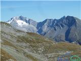
 | Planina Blato - Kanjavec (Za Kopico)
Kanjavec is a 2,569-meter-high mountain located between Dolič and Hribarice. From the summit, which has a logbook box and a stamp, a beautiful vi...
5 h 35 min |
 | Valvasorjev dom pod Stolom - Hochstuhl/Stol (Zabreška way)
Stol is, at 2,236 m, the highest peak in the Karawanks. From the summit, which has a registration box and stamp, a beautiful view opens onto the ...
3 h 20 min |
 | Ljubelj - Hochstuhl/Stol (lower path)
Stol is, at 2,236 m, the highest peak in the Karawanks. From the summit, which has a registration box and stamp, a beautiful view opens onto the ...
4 h 50 min |
 | Tinčkova koča - Hochstuhl/Stol (via Smokuška planina)
Stol is, at 2,236 m, the highest peak in the Karawanks. From the summit, which has a registration box and stamp, a beautiful view opens onto the ...
4 h 15 min |
 | Planina Kuhinja - Krn (via Krnska škrbina)
Krn, at 2244 m, is the highest peak of the Krn mountain group, which rises steeply above the central part of the Soča River. From the summit, fea...
3 h 30 min |
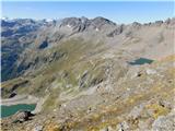
 | Kriška planina - Kalški greben (via planina Koren)
Kalški greben is a 2224 m high peak and the highest point of the ridge bearing the same name. From the summit, where there is a summit register a...
3 h 45 min |
| Planina Jezerca - Kalški greben (via planina Koren)
Kalški greben is a 2224 m high peak and the highest point of the ridge bearing the same name. From the summit, where there is a summit register a...
4 h |
| Markova raven - Kalški greben (on marked path)
Kalški greben is a 2224 m high peak and the highest point of the ridge bearing the same name. From the summit, where there is a summit register a...
4 h 30 min |
 | Planina Kuhinja - Batognica (via jezero v Lužnici)
Batognica is a 2164 m high mountain that was the site of the so-called mine warfare during World War I. Remnants of the fighting between Italian ...
4 h |
 | Goldberg - Jaukenstöckl
Jaukenstöckl is a 2209 m high peak on the western side of the panoramic Jauken ridge. From the summit, where a statue of the Virgin Mary stands, ...
3 h 45 min |
 | Goldberg - Jaukenhöhe
Jaukenhöhe is a little-visited peak in the Jauken ridge. It lies west of Torkofel, the highest point in the ridge at 2276 m. The grassy, steep su...
3 h 45 min |
 | Dösner Alm - Säuleck
Säuleck is a 3,086-meter peak in the High Tauern. The summit features a cross and summit register box, providing nice views of nearby peaks such ...
5 h 30 min |
 | Prebersee - Preber
Preber is a 2740 m high peak located in the heart of the Schladminger Tauern mountain group. The summit, where a cross stands, is a very popular ...
3 h 30 min |
 | Prebersee - Preber (via Mühlbachtörl)
Preber is a 2740 m high peak located in the heart of the Schladminger Tauern mountain group. The summit, where a cross stands, is a very popular ...
3 h 45 min |
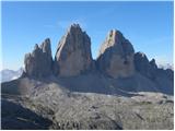
 | Piano Fiscalino / Fischleinboden - Croda Fiscalina di Mezzo / Oberbachernspitze
Croda Fiscalina di Mezzo, or in German Oberbachernspitze, is a 2675-meter-high mountain located in the heart of the Dolomiti di Sesto / Sextner D...
4 h |
 | Piano Fiscalino / Fischleinboden - Sasso di Sesto / Sextnerstein
Sasso di Sesto is a 2,539-meter-high peak located in the Sexten Dolomites Nature Park. This easily accessible peak offers exceptional views of th...
3 h 30 min |
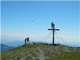
 | Bad Kleinkirchheim - Wöllaner Nock
Wöllaner Nock is a 2145 m high peak located south of the ski area and the settlement Bad Kleinkirchheim. From the spacious summit, where a larger...
3 h 45 min |
| Bad Kleinkirchheim - Wöllaner Nock (by road)
Wöllaner Nock is a 2145 m high peak located south of the ski area and the settlement Bad Kleinkirchheim. From the spacious summit, where a larger...
4 h 15 min |
 | Colfosco - Sas Ciampac
Sas Ciampac is a 2672-meter-high peak in the Puez group. From the summit, which features a small wooden cross, there is a nice view of the Puez g...
3 h 30 min |
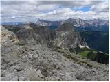
 | Rifugio Pederü - L'Ciaval / Kreuzkofel (path 12)
L'Ciaval / Kreuzkofel is a 2,907-meter-high mountain in the Lavarella group. The mountain and the entire ridge it's located in are recognizable b...
4 h 45 min |
| Rifugio Pederü - L'Ciaval / Kreuzkofel (path 7)
L'Ciaval / Kreuzkofel is a 2,907-meter-high mountain in the Lavarella group. The mountain and the entire ridge it's located in are recognizable b...
4 h 50 min |
 | Stary Smokovec - Slavkovsky štit
Slavkovsky štit is the fourth-highest peak in the High Tatras, standing at 2,452 meters. It is located south of the Velká Studená dolina valley a...
4 h 10 min |
 | Mallnitz - Greilkopf
Greilkopf is a 2,581 m high mountain in the Ankogel group of the Hohe Tauern in Austria above the town of Mallnitz. It is a popular winter destin...
5 h 30 min |
 | Mallnitz - Feldseekopf (via Feldseescharte)
Feldseekopf, at 2,864 m, is as high as Triglav. The mountain is located in the Goldberg group of the Hohe Tauern in Austria and receives far fewe...
6 h 10 min |
 | Parking below Jamnigalm - Feldseekopf (via Feldseecharte)
Feldseekopf, at 2,864 m, is as high as Triglav. The mountain is located in the Goldberg group of the Hohe Tauern in Austria and receives far fewe...
3 h 50 min |
 | Turracher Höhe - Eisenhut (via Straßburger Spitz)
Eisenhut, at 2,441 meters, is the highest peak in the Gurktal Alps, which stretch across the basin of the Krka/Gurk River and descend to the nort...
5 h 45 min |
| Turrach - Eisenhut
Eisenhut, at 2,441 meters, is the highest peak in the Gurktal Alps, which stretch across the basin of the Krka/Gurk River and descend to the nort...
4 h 30 min |
| Turrach - Eisenhut (via Straßburger Spitz)
Eisenhut, at 2,441 meters, is the highest peak in the Gurktal Alps, which stretch across the basin of the Krka/Gurk River and descend to the nort...
5 h |
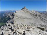
 | Turrach - Straßburger Spitz
Straßburger Spitz is a 2,404-meter-high peak located between the summits of Eisenhut (2,441 m) and Wintertalernock (2,394 m). From the top, where...
4 h |
 | Turrach - Wintertalernock
Wintertalernock is a 2,394-meter-high peak located southeast of the highest summit of the Gurktal Alps, Eisenhut. From the top, where a cross sta...
4 h 15 min |
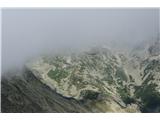
 | Gozdec - Vrh Osojnic
Vrh Osojnic is a 2,371-meter-high peak located between the Dom Petra Skalarja hut on Kanin and Hudi Vršič. From the summit, where a cairn stands,...
4 h 40 min |
 | Parking Sulzenauhütte - Gamsspitzl (via Sulzenauhütte and Seescharte)
Gamsspitzl is a less prominent three-thousander located on a long ridge stretching north from the summit plateaus of Wilder Freiger. Due to its e...
5 h 15 min |
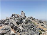
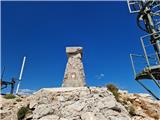
 | Nida - Timios Stavros / Psiloritis (Kreta)
Timios Stavros is Crete's highest mountain at 2,456 meters and also the highest among the Greek islands. Due to its topographic prominence, it is...
4 h 15 min |
 | Agion Pneuma (Avrakondes) - Spathi (Crete)
Spathi (Gr. Σπαθί) is at 2,148 m the highest mountain of the Dikti massif (Gr. Δικτή) on the Greek island of Crete. Among Crete's three massifs w...
4 h |
 | Masna Luka - Pločno
Pločno is the highest peak of the Čvrsnica range and the fourth highest peak in Bosnia and Herzegovina. At its highest point is a geodetic pillar...
4 h 30 min |