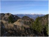
 | Tuškov Grič - Blegoš (via Črni vrh)
Blegoš is a 1,562-metre-high mountain located between the Selška Sora and Poljanska Sora rivers. From the grassy summit, where there is a stamp a...
2 h 45 min |
 | Črnivec - Lepenatka
Lepenatka is a grassy peak located south of the 1557-metre-high Rogatec. From the summit, which has a summit register box and stamp, there is a b...
3 h 15 min |
 | Preval - Koprivnik
Koprivnik is a 1393-meter-high mountain located between Blegoš and Mladi vrh. From the summit, which has a registration box and a stamp, the view...
3 h 15 min |
 | Črnivec - Vivodnik
Vivodnik, at 1508 meters, is the highest peak of Menina planina, a plateau rising south of Gornji Grad. From the summit, which has a small observ...
4 h 30 min |
 | Podkraj - Vojkova koča na Nanosu
Vojkova koča is located on the southern edge of the high karst Nanos plateau, near Pleša. This is the prominent peak with television transmitters...
4 h 30 min |
 | Gorenje pri Zrečah - Rogla
Rogla is a peak in the middle of the eponymous ski resort. The peak is forested with a small clearing on which stands a lookout tower. The tower ...
2 h 35 min |
 | Petrovo Brdo - Krevl
Krevl is a 1515-meter-high peak situated south of the Kobla ski area, more precisely between the Kobla peak and Kravja Črna gora. From the summit...
2 h 30 min |
 | Podmeja - Črni vrh (Čemšeniška planina)
Črni vrh is the highest peak of Čemšeniška planina and, at 1,204 m, the second-highest peak in Posavsko hribovje. The summit has a logbook box bu...
3 h 30 min |
| Dom pod Reško planino - Črni vrh (Čemšeniška planina)
Črni vrh is the highest peak of Čemšeniška planina and, at 1,204 m, the second-highest peak in Posavsko hribovje. The summit has a logbook box bu...
3 h |
 | Jeršiče - Sveta Trojica (pot je trajno ZAPRTA!)
Sveta Trojica is a distinctly panoramic 1106-meter peak located southwest of the Javorniki. From the summit, where a beautifully restored histori...
2 h 40 min |
 | Črni Vrh - Javornik (above Črni Vrh) (via Šajsna Ravan)
Javornik is a forested peak located southeast of Črni Vrh. In 1972, a wooden observation tower was built on it, rising above the treetops and off...
2 h 30 min |
 | Podkraj - Javornik (above Črni Vrh)
Javornik is a forested peak located southeast of Črni Vrh. In 1972, a wooden observation tower was built on it, rising above the treetops and off...
2 h 30 min |
 | Šmartno na Pohorju - Žigartov vrh (via Bojtina)
Žigartov vrh, at 1,346 meters, is the highest peak in the eastern part of Pohorje. An "observation" tower once stood on the summit, erected solel...
3 h 15 min |
 | Platak - Veliki Risnjak
Veliki Risnjak, at 1528 m, is the highest peak of Risnjak National Park. From the summit, which has a logbook box and stamp, there is a very nice...
3 h 30 min |
 | Predmeja - Veliki Rob
Veliki Rob is a panoramic peak situated between Kuclj (1237 m) and Čaven (1185 m). From the summit, where there is a cross, there is a nice view ...
3 h |
 | Zrmanja Railway Station - Poštak
Poštak (also "Kečina kosa") is a scenic mountain at the junction of Lika and Dalmatia. It belongs to the Lička Plješivica range as an extension, ...
2 h 30 min |
 | 18th hairpin turn of road on Strma Reber - Cerk
Cerk, at 1,192 meters, is the highest peak of Borovška gora, a range situated between the Kolpa River valley and Goteniški Snežnik. From the summ...
2 h 40 min |
 | Poče - Medrce (winter way)
Medrce is a 1,410-meter-high peak located between Porezen and Hum. From the summit, which features an old bunker, there are nice views of Kojca, ...
2 h 40 min |
| Poče - Medrce (via Labinjske lehe)
Medrce is a 1,410-meter-high peak located between Porezen and Hum. From the summit, which features an old bunker, there are nice views of Kojca, ...
2 h 30 min |
 | Pod Peco (Koželj) / Koprein-Petzen (Koschiel) - Špičasti vrh / Spitzberg
Špičasti vrh / Spitzberg is a 1,551-meter-high peak located above the Maroldčeva planina / Maroldalm mountain pasture. Because the peak is locate...
2 h 30 min |
 | Kuna Konavoska - Ilijin vrh
Ilijin vrh, also known as Sveti Ilija, is the main peak of the Sniježnica Konavoska mountain ridge, which is also the southernmost mountain ridge...
2 h 30 min |
 | Široko - Veliki vrh (above Lom) (via Kanalski Lom - on trail Lom is my home)
Veliki vrh is located on the northeastern part of the Banjška planota plateau, which rises above Čepovani dol, the Soča river valley, and the Idr...
2 h 40 min |
 | Veliko Tinje - Veliki vrh (on Pohorje)
Veliki vrh is a 1344-meter-high peak located above the RTC Jakec - Trije kralji ski slope. The highest point of the peak is in the forest, but ju...
2 h 30 min |
| Šmartno na Pohorju - Veliki vrh (on Pohorje)
Veliki vrh is a 1344-meter-high peak located above the RTC Jakec - Trije kralji ski slope. The highest point of the peak is in the forest, but ju...
2 h 45 min |
 | Zelovo - Svilaja (past Umac)
Svilaja is a 1509-meter grassy peak above Peručko Lake, north of the town of Sinj. The summit features a cross and a concrete pillar. From the to...
3 h |
 | Alpl (Zisleranger Weg) - Teufelstein (past Edelweißhütte)
Teufelstein is a 1,498-meter-high mountain in the Fischbacher Alpen group. At the summit there is a cross with a summit logbook, and slightly bel...
2 h 40 min |
| Alpl (Waldschulle Alpl) - Teufelstein
Teufelstein is a 1,498-meter-high mountain in the Fischbacher Alpen group. At the summit there is a cross with a summit logbook, and slightly bel...
2 h 30 min |
 | Gasen - Plankogel (by learning trail)
Plankogel is a 1531-meter-high mountain situated in the Almenland nature park. From the panoramic summit, where a cross stands, a beautiful view ...
2 h 35 min |
 | Laufnitzgraben - Bei den drei Pfarren
Bei den drei Pfarren ("At the Three Parishes") is a crossroads from which a stunning panoramic view opens towards the south and west, all the way...
2 h 30 min |