 | Zgornja Besnica (Podrovnik) - Sveti Jošt above Kranj (via Gaber)
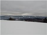
Sveti Jošt above Kranj is a hill located west of the slightly lower Šmarjetna gora. From the summit, where the Church of St Jošt stands alongside...
2 h 30 min |
 | Vače - Zasavska Sveta gora (on a slope)
Zasavska Sveta Gora is a popular excursion destination located between Litija and Izlake. From the summit, where the parish church of the Nativit...
2 h 30 min |
| Vače - Zasavska Sveta gora (on the ridge)
Zasavska Sveta Gora is a popular excursion destination located between Litija and Izlake. From the summit, where the parish church of the Nativit...
2 h 35 min |
 | Kandrše (Trata) - Limbarska gora
Limbarska gora is located northeast of Moravče. From the summit, there is a beautiful view of the surrounding peaks, and in good weather, the Kam...
3 h 15 min |
| Blagovica - Limbarska gora (Blagovica - Limbarska gora - Blagovica)
Limbarska gora is located northeast of Moravče. From the summit, there is a beautiful view of the surrounding peaks, and in good weather, the Kam...
2 h 9 min |
 | Žiri - Vrh Svetih Treh Kraljev
The Church of the Holy Three Kings stands on a panoramic hill above the village of Vrh Svetih Treh Kraljev. The summit features a panorama board ...
2 h 30 min |
 | Veliko Trebeljevo - Janče
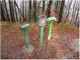
Janče is a 792-meter-high peak situated between the Sava River and the Besnica stream valley. From the summit, where a mountain hut stands and th...
2 h 15 min |
 | Katarija - Slivna (Pivkelj)
Slivna, also known as Pivkelj (or Pivkelj turn), lies south of Limbarska gora. Pivkelj is the highest point of the Moravška planinska pot and at ...
1 h 55 min |
 | Kandrše (Trata) - Slivna (Pivkelj) (via Sveti Florjan)
Slivna, also known as Pivkelj (or Pivkelj turn), lies south of Limbarska gora. Pivkelj is the highest point of the Moravška planinska pot and at ...
2 h 20 min |
| Kandrše (Trata) - Slivna (Pivkelj) (via GEOSS)
Slivna, also known as Pivkelj (or Pivkelj turn), lies south of Limbarska gora. Pivkelj is the highest point of the Moravška planinska pot and at ...
2 h |
 | Podmeja - Reška planina (on ridge)
Reška planina is a peak in the Posavsko hribovje, located southwest of Prebold. The summit is in the forest and marked by a sign on a tree; it li...
2 h 5 min |
 | Jablance - Skalica (Bohor) (via Koča na Bohorju and Veliki Javornik)
Skalica is a lesser-known peak on the western part of Bohor. From the summit, which has a logbook box, there is a nice view to the south and west...
2 h 50 min |
| Šentvid pri Planini - Skalica (Bohor) (via Veliki Javornik)
Skalica is a lesser-known peak on the western part of Bohor. From the summit, which has a logbook box, there is a nice view to the south and west...
3 h |
 | Skadanščina - Velika Plešivica
Velika Plešivica is a 908-meter peak located between Slavnik and the lesser-known Mala Plešivica. The summit, which features a destroyed logbook ...
2 h 15 min |
 | Velike Lašče - Kamen vrh (via Gornje Retje and Grmada)
Kamen Vrh is a panoramic hill located on the northern edge of Mala Gora. From the summit, surrounded by low bushes, there are fine views of parts...
2 h 35 min |
 | Dule - Grmada on Mala gora
Grmada (also Grmada above Ortnek) is an 887-meter-high peak located above the village of Vrh pri Poljanah in the Mala Gora range. Just a few mete...
2 h |
 | Velike Lašče - Grmada on Mala gora (via Gornje Retje)
Grmada (also Grmada above Ortnek) is an 887-meter-high peak located above the village of Vrh pri Poljanah in the Mala Gora range. Just a few mete...
2 h |
| Velike Lašče - Grmada on Mala gora (via Kamen vrh)
Grmada (also Grmada above Ortnek) is an 887-meter-high peak located above the village of Vrh pri Poljanah in the Mala Gora range. Just a few mete...
2 h |
 | Ortnek - Stene svete Ane
Stene Svete Ane is a vegetated peak located near the Planinska Koča pri Sveti Ani on Mala Gora. A small observation tower stands on the summit, e...
2 h 30 min |
 | Ernejčkov graben - Sivka
Sivka is a grassy peak at the far western end of Polhograjsko hribovje. On clear days, it offers breathtaking views from Snežnik across Javorniki...
2 h |
 | Ljubljanica - Sivka
Sivka is a grassy peak at the far western end of Polhograjsko hribovje. On clear days, it offers breathtaking views from Snežnik across Javorniki...
2 h 25 min |
 | Grčarevec - Grmada (Planinska gora) (Jakobova pot)
Grmada is an 873-meter-high peak rising west of Planinsko polje. Although the summit is forested, a viewpoint just below it offers a stunning vie...
1 h 50 min |
 | Ledinsko Razpotje - Medvedje Brdo (east path)
Medvedje Brdo is a small settlement located north of Hotedršica. The highest point of the village is a pleasant viewpoint on Šinkovcov grič (814 ...
3 h 10 min |
| Ledinsko Razpotje - Medvedje Brdo (west path)
Medvedje Brdo is a small settlement located north of Hotedršica. The highest point of the village is a pleasant viewpoint on Šinkovcov grič (814 ...
3 h 15 min |
 | Zavrh pri Trojanah - Golčaj
Golčaj is a 690 m high hill rising south of Blagovica. At the summit, which has a logbook box and stamp, stands a NOB monument; a few tens of met...
2 h 30 min |
 | Kandrše (Trata) - Golčaj
Golčaj is a 690 m high hill rising south of Blagovica. At the summit, which has a logbook box and stamp, stands a NOB monument; a few tens of met...
3 h 20 min |
 | Trojane - Špilk
Špilk is a 956 m high peak located north of Blagovica. At the mostly forested summit, PD Blagovica has set up a small bivouac with a bench and ta...
2 h 30 min |
 | Trojane - Špilk (past the cross Na Kočni)
Špilk is a 956 m high peak located north of Blagovica. At the mostly forested summit, PD Blagovica has set up a small bivouac with a bench and ta...
2 h 15 min |
 | Mislinja - Fričev vrh (via Završe)
Fričev vrh is an 881 m high hill located south of Mislinjska Dobrava. From the summit, which has a logbook box with book and stamp inside, there ...
2 h |
 | Podgorje - Golič (via hunting cottage)
Golič is a grassy ridge extending from Kojnik to the Slovenian-Croatian border and continuing as the Žbevnica ridge on the Croatian side. Due to ...
2 h 40 min |
 | Kopačnica - Veliki vrh (Lajše)
Veliki vrh is an almost 900-meter-high elevation rising south of Cerkno. From the summit, which features several television and radio transmitter...
2 h 50 min |
 | Vinska Gora - Ramšakov vrh (easy path)
Ramšakov vrh is the highest point of the circular path around Vinska Gora. At the 970 m high summit, next to the benches, there is also a stamp b...
2 h |
 | Vinska Gora - Ramšakov vrh (via farm Vodošek)
Ramšakov vrh is the highest point of the circular path around Vinska Gora. At the 970 m high summit, next to the benches, there is also a stamp b...
2 h |
 | Šentvid pri Planini - Debeli vrh (Bohor)
Debeli vrh is a 921-meter-high peak on Bohor between Veliki Koprivnik and Oslica. Covered in dense forest, it offers no views. A marked hiking tr...
2 h |
 | Lovrenc na Pohorju - Hlebov vrh (Rdeči Breg)
Rdeči breg stretches between the Radoljna gorge to the east, the Drava to the north, and the Velka stream to the east. It is separated from the m...
2 h 10 min |
 | Lovrenc na Pohorju - Hlebov vrh (Rdeči Breg) (via Povh and Brabar)
Rdeči breg stretches between the Radoljna gorge to the east, the Drava to the north, and the Velka stream to the east. It is separated from the m...
2 h 30 min |
| Lovrenc na Pohorju - Hlebov vrh (Rdeči Breg) (via Kapus)
Rdeči breg stretches between the Radoljna gorge to the east, the Drava to the north, and the Velka stream to the east. It is separated from the m...
2 h 40 min |
 | Ravne - Loška stena
Loška stena rises above Zgornja Kolpska dolina, more precisely above the villages of Grintovec pri Osilnici, Ložec, and Ribjek. From the summit o...
1 h 50 min |
| Bezgovica - Loška stena
Loška stena rises above Zgornja Kolpska dolina, more precisely above the villages of Grintovec pri Osilnici, Ložec, and Ribjek. From the summit o...
2 h 40 min |
| 18th hairpin turn of road on Strma Reber - Loška stena
Loška stena rises above Zgornja Kolpska dolina, more precisely above the villages of Grintovec pri Osilnici, Ložec, and Ribjek. From the summit o...
2 h 25 min |
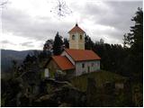
 | Radeljski prelaz - Sveti Pankracij (Radelca) (Austrian path)
The Church of St. Pankracij on Radelca is located at an altitude of 900 meters, directly on the border ridge between Slovenia and Austria. The or...
3 h |
| Radeljski prelaz - Sveti Pankracij (Radelca) (via Sveti Urban)
The Church of St. Pankracij on Radelca is located at an altitude of 900 meters, directly on the border ridge between Slovenia and Austria. The or...
3 h 15 min |
 | Lovrenc na Pohorju - Klančnik (Glančnik) (via Kapus)
Klančnik (Glančnik on some maps) is an 877-meter-high peak situated above the right bank of the Drava River, just a few minutes' walk from the Hu...
2 h |
 | Lovrenc na Pohorju - Klančnik (Glančnik) (via Povh, Brabar and Hudej)
Klančnik (Glančnik on some maps) is an 877-meter-high peak situated above the right bank of the Drava River, just a few minutes' walk from the Hu...
2 h 25 min |
| Janževski Vrh (Uran) - Klančnik (Glančnik) (via Sveti Ignacij)
Klančnik (Glančnik on some maps) is an 877-meter-high peak situated above the right bank of the Drava River, just a few minutes' walk from the Hu...
2 h |
 | Deutschfeistritz - Schartnerkogel (on road)
Schartnerkogel is a 931-meter-high hill above the town Deutschfeistritz (Nemška Bistrica) in the western part of the Graz Mountains. A cross stan...
2 h |
 | Prelaz Vrhe - Maceljska gora (via source of Sotla)
Maceljska gora is the highest peak of Macelj, a range located south of the settlement of Žetale along the border with Croatia....
1 h 50 min |
 | Male Drage - Okrugljak (via Razdrto)
Okrugljak is a forested hill located in the eastern part of Gorski Kotar, near the border with Slovenia. The summit was formerly an HPO point (no...
2 h 30 min |