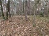
 | Sotina - Činčev breg (via the source of mineral water)
Činčev breg (also Činčov breg) is a 375-meter-high hill located near the border with Austria, more precisely above the eponymous village Činčev B...
30 min |
| Sotina - Činčev breg (via Činčev Breg)
Činčev breg (also Činčov breg) is a 375-meter-high hill located near the border with Austria, more precisely above the eponymous village Činčev B...
25 min |
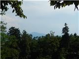
 | SSK Sam Ihan - Sveta Kunigunda on Tabor above Ihan
The Church of St. Kunigunda on Tabor above Ihan was first mentioned in 1519. From the church or its nearby surroundings, there are limited views ...
35 min |
 | Grad - Pepelšček
Pepelšček is a panoramic grassy hill amid fields, rising above the eastern part of the Grad settlement. From the top, it offers nice views of the...
25 min |
 | Podsreda - Stara sveta gora (Way of the cross)
Stara sveta gora, or locally "Stare gore nad Podsredo", is a hill northeast of Podsreda on the southern slopes of the hills separating the valley...
25 min |
 | Podsreda - Stara sveta gora (by Stations of the Cross)
Stara sveta gora, or locally "Stare gore nad Podsredo", is a hill northeast of Podsreda on the southern slopes of the hills separating the valley...
25 min |
| Podsreda - Stara sveta gora (by road)
Stara sveta gora, or locally "Stare gore nad Podsredo", is a hill northeast of Podsreda on the southern slopes of the hills separating the valley...
30 min |
 | Ljubljana (Koseze) - Cankarjev vrh (Rožnik) (on footpath)
Cankarjev vrh is a 394 m high hill located east of Ljubljana Zoo. From the summit, where a church and a restaurant stand, the surrounding forest ...
30 min |
 | Ljubljana (Izletniška ulica) - Straža (past Tabor)
A forested peak that fails to give you the feeling you're in the hills. There are no viewsjust beech trees here and there. However, you can find ...
30 min |
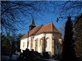 | Ženavlje (memorial plaque) - Church of St. Anne in Boreča
The Church of St. Anne in Boreča is located above the southwestern part of the settlement on a hill amid a mostly pine forest. In the church, pro...
30 min |
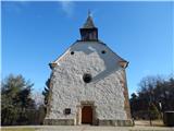 | Boreča - Church of St. Anne in Boreča
The Church of St. Anne in Boreča is located above the southwestern part of the settlement on a hill amid a mostly pine forest. In the church, pro...
25 min |
 | Ljubljana (Soteška pot) - Oljska gora
Oljska gora is a 401-meter-high hill north of Ljubljana, more precisely between Nadgorica, Podgorica, and Dragomelj. At the summit, there is a su...
25 min |
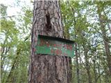
 | Ljubljana (Rakovnik) - Luknje
Luknje is a 438-meter-high peak in the northwestern part of Golovec. At the summit, where the forest educational point Planetarij is located, mod...
30 min |
 | Preval - Stražni vrh
Stražni vrh is a forest-covered peak located between Podutik and Stranska vas. The summit, which is mostly climbed by locals, is marked by a smal...
30 min |
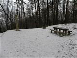 | Ljubljana (London) - Črni hrib (Golovec)
Črni hrib is a 440 m high hill in the central part of Golovec. The summit, which has a NOB monument and a bench with a table, is crossed by the T...
30 min |
 | Ljubljana (Bokalce) - Klobuk at Ljubljana
Klobuk is a 441-meter-high peak located west of Ljubljana, more precisely above Stranska vas at Dobrova. From the top, a nice view opens up on pa...
30 min |
 | Dragomer (bajer) - Strmec (above Dragomer) (past Ferjanka)
Strmec is a distinct, forest-covered peak situated between Dragomer and Log. Numerous logging trails lead to the top. It is located south of the ...
30 min |
 | Dragomer (OŠ Log-Dragomer) - Strmec (above Dragomer)
Strmec is a distinct, forest-covered peak situated between Dragomer and Log. Numerous logging trails lead to the top. It is located south of the ...
30 min |
 | Ljubljana (London) - Mazovnik (Golovec)
Mazovnik, at 450 m, is the highest peak of Golovec, a hill range located on the southeastern outskirts of Ljubljana. Golovec remained bare until ...
35 min |
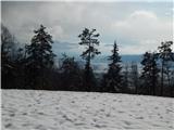
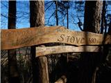 | Otoče - Stovc (Stolec)
Stovc or Stolec (also known as Zaloški Stol on maps) is a well-maintained viewpoint above Zaloše. It offers a beautiful view towards the valley, ...
30 min |
 | Zaloše - Stovc (Stolec)
Stovc or Stolec (also known as Zaloški Stol on maps) is a well-maintained viewpoint above Zaloše. It offers a beautiful view towards the valley, ...
25 min |
 | RC Korant - Ajdovščina nad Ihanom (on cart track)
Ajdovščina above Ihan is a hill covered in mixed forest, north of Dol pri Ljubljani. Several footpaths and cart tracks lead to the top. In summer...
25 min |
 | Church of St. Lovrenc above Dragomer - Vrhovčev grič
Vrhovčev grič is an indistinct, forested peak located just a few meters off the marked trail between Debeli hrib and Strmca....
30 min |
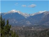
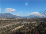
 | Globoko - Zjavka
Zjavka is a viewpoint above Kamna Gorica from which a beautiful panorama opens onto Kamna Gorica and part of the Lipniška Valley. At the viewpoin...
30 min |
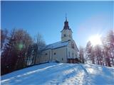
 | Povir - Gura
Gura is a 510-meter-high hill located above Povir. From the summit, where the Church of the Assumption of Mary stands, there is a beautiful view ...
35 min |
 | Srednja vas-Poljane - Church of the Holy Cross at Brezje above Srednja vas (on footpath)
The Church of the Holy Cross at Brezje above Srednja vas is situated on a hill above the left bank of the Poljanska Sora River. From the church, ...
25 min |
| Dobje - Church of the Holy Cross at Brezje above Srednja vas
The Church of the Holy Cross at Brezje above Srednja vas is situated on a hill above the left bank of the Poljanska Sora River. From the church, ...
25 min |
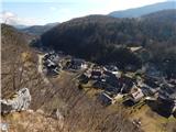
 | Globoko - Ojstra peč
Ojstra peč is a panoramic rocky promontory between the Lipniška Valley and the Sava River valley at Globoko, dropping steeply toward the fields a...
35 min |