 | Sele-Zvrhnji Kot (Male) / Zell-Oberwinkel (Male) - Loibler Baba/Košutica (over Hajnževo sedlo)
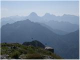
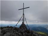
Košutica (also known as Ljubeljska Baba) is a panoramic mountain north of the western ridge of Košuta. From the summit, marked by a small cross a...
4 h 15 min |
 | Na Razpotju - Planjava
Planjava is a smaller mountain group east of Kamniško sedlo. It has two peaks eastern and western. The marked path leads to the eastern peak, wh...
5 h |
| Dom Planincev v Logarski dolini - Planjava
Planjava is a smaller mountain group east of Kamniško sedlo. It has two peaks eastern and western. The marked path leads to the eastern peak, wh...
4 h 55 min |
 | Mače - Storžič
Storžič is a 2132 m high mountain located in the western part of the Kamnik-Savinja Alps. From the summit, where there is a cross, a beautiful vi...
4 h |
| Laško (obračališče nad vasjo) - Storžič (via Kališče)
Storžič is a 2132 m high mountain located in the western part of the Kamnik-Savinja Alps. From the summit, where there is a cross, a beautiful vi...
3 h 20 min |
| Laško - Storžič (via Sveti Lovrenc and over Bašeljski preval)
Storžič is a 2132 m high mountain located in the western part of the Kamnik-Savinja Alps. From the summit, where there is a cross, a beautiful vi...
4 h 25 min |
| Bašelj - Storžič (via Sveti Lovrenc and over Bašeljski preval)
Storžič is a 2132 m high mountain located in the western part of the Kamnik-Savinja Alps. From the summit, where there is a cross, a beautiful vi...
5 h 5 min |
| Bašelj - Storžič
Storžič is a 2132 m high mountain located in the western part of the Kamnik-Savinja Alps. From the summit, where there is a cross, a beautiful vi...
4 h |
| Bašelj - Storžič (via hospital Košuta)
Storžič is a 2132 m high mountain located in the western part of the Kamnik-Savinja Alps. From the summit, where there is a cross, a beautiful vi...
4 h 10 min |
| MHE Zabukovec - Storžič (via Bašeljski preval)
Storžič is a 2132 m high mountain located in the western part of the Kamnik-Savinja Alps. From the summit, where there is a cross, a beautiful vi...
4 h |
 | Dom v Kamniški Bistrici - Brana
Brana is a mountain above Kamniško sedlo. From the spacious summit, which has a registration box and a small cross, there is a very beautiful vie...
5 h |
 | Belca - Mittagskogel/Kepa
Kepa (also Jepa, German: Mittagskogel) is a panoramic mountain in the western Karavanke, located on the border ridge between Slovenia and Austria...
4 h 15 min |
 | Podrožca / Rosenbach - Mittagskogel/Kepa
Kepa (also Jepa, German: Mittagskogel) is a panoramic mountain in the western Karavanke, located on the border ridge between Slovenia and Austria...
5 h 10 min |
| Čemernica / Tschemernitzen - Mittagskogel/Kepa
Kepa (also Jepa, German: Mittagskogel) is a panoramic mountain in the western Karavanke, located on the border ridge between Slovenia and Austria...
5 h 5 min |
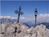
 | Na Razpotju - Ojstrica (via Škarje)
Ojstrica, named for its sharp shape, rises steeply above Korošica, the Logarska Dolina valley, and Robanov Kot. From the summit, which has a regi...
4 h 15 min |
| Dom Planincev v Logarski dolini - Ojstrica (via Škarje)
Ojstrica, named for its sharp shape, rises steeply above Korošica, the Logarska Dolina valley, and Robanov Kot. From the summit, which has a regi...
4 h 10 min |
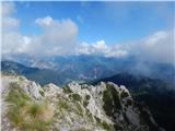
 | Rogovilec - Velika Raduha (via planina Arta)
Velika Raduha, at 2062 m, is the highest peak of the Raduha range, which rises steeply east of Robanov Kot. From the summit, with its registratio...
4 h 30 min |
 | Koča pri Savici - Mala Tičarica
Mala Tičarica is a highly panoramic mountain above the Twin Triglav Lakes. From the summit there is a beautiful view toward the Koča pri Triglavs...
4 h 10 min |
 | Koča pri Savici - Zasavska koča na Prehodavcih
The Zasavska koča na Prehodavcih mountain hut is located on a panoramic rise above the Valley of the Triglav Lakes. From the hut, open in the sum...
5 h 10 min |
 | Koča pri Savici - Pršivec
Pršivec is a panoramic mountain above Lake Bohinj. The view is extensive in all directions: Triglav and the surrounding mountains are clearly vis...
4 h 10 min |
 | Pred Belo - Konj
Konj is an 1803 m high peak located between Velika Planina and Presedljaj. From the summit there is a beautiful view of the highest peaks of the ...
3 h 45 min |
 | Zavrzelno - Rombon
Rombon is a scenic mountain above Bovec. It is particularly known for having the most artificial tunnels in Slovenia. During the First World War,...
4 h 45 min |
| Kluže Fortress - Rombon
Rombon is a scenic mountain above Bovec. It is particularly known for having the most artificial tunnels in Slovenia. During the First World War,...
5 h |
 | Možnica - Jerebica
Jerebica is a mountain located on the border between Slovenia and Italy, between the Možnica and Jezerska valleys. From the summit, where there i...
5 h |
 | Valbruna - Jof di Miezegnot/Poldašnja špica (via Planina Ravne)
Poldašnja špica is the easternmost two-thousander in the Malborghetto mountains group (Monti di Malborgheto). From the mountain, which has many r...
3 h 45 min |
| Valbruna - Jof di Miezegnot/Poldašnja špica (via Planina Strehica)
Poldašnja špica is the easternmost two-thousander in the Malborghetto mountains group (Monti di Malborgheto). From the mountain, which has many r...
4 h |
 | Malborghetto - Jof di Miezegnot/Poldašnja špica
Poldašnja špica is the easternmost two-thousander in the Malborghetto mountains group (Monti di Malborgheto). From the mountain, which has many r...
4 h |
 | Ovčja vas / Valbruna - Kamniti lovec / Cima del Cacciatore
Kamniti lovec is a popular excursion point above Trbiž. Due to the short approach, shortened by the cable car to Višarje, it is well visited. Two...
4 h |
 | Žabnice / Camporosso in Valcanale - Kamniti lovec / Cima del Cacciatore
Kamniti lovec is a popular excursion point above Trbiž. Due to the short approach, shortened by the cable car to Višarje, it is well visited. Two...
3 h 30 min |
 | Gostišče Firšt - Govca (Olševa)
Govca is the highest peak of the Olševa range, rising above Koprivna, Solčava, and Remšenik (Remšenik/Remschenig is a valley on the Austrian side...
3 h 45 min |
 | Na Razpotju - Krofička (marked way)
Krofička (or Grofička according to some records) is a peak located northeast of Ojstrica. From the summit, which steeply descends towards Logarsk...
3 h 40 min |
| Dom Planincev v Logarski dolini - Krofička (marked path)
Krofička (or Grofička according to some records) is a peak located northeast of Ojstrica. From the summit, which steeply descends towards Logarsk...
3 h 35 min |
 | Val Aupa - Sernio (via normale)
Sernio (Ital. Monte Sernio / Furlan: Serenât or Crete di Seregnò) is a 2,187 m high mountain in the Carnic Alps in Italy, between the Aupa river ...
4 h 30 min |
 | Sankt Ilgen (Der Bodenbauer) - Hochschwab
Hochschwab, at 2,277 meters, is the highest peak of its namesake mountain group in the Northern Limestone Alps. From the summit, where a cross st...
4 h 25 min |
 | Jassing - Großer Ebenstein (jugovzhodni vrh)
Ebenstein (southeastern peak) is a scenic pre-summit with a cross and a summit register, reached via a marked trail. Because a cross stands on it...
4 h 15 min |