 | Ljubljana (London) - Mazovnik (Golovec)
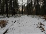
Mazovnik, at 450 m, is the highest peak of Golovec, a hill range located on the southeastern outskirts of Ljubljana. Golovec remained bare until ...
35 min |
 | Ljubljana (London) - Črni hrib (Golovec)
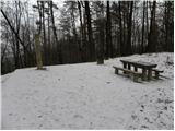
Črni hrib is a 440 m high hill in the central part of Golovec. The summit, which has a NOB monument and a bench with a table, is crossed by the T...
30 min |
 | Podgrad - Castle Stari grad (Stari Osterberg) (on cart track)
Stari grad, or Stari Osterberg, was first mentioned in the 12th century (less likely as early as 1015), at which time the castle belonged to the ...
30 min |
 | Podgrad - Castle Stari grad (Stari Osterberg) (via millstone quarry)
Stari grad, or Stari Osterberg, was first mentioned in the 12th century (less likely as early as 1015), at which time the castle belonged to the ...
45 min |
 | Hraše - Smledniški hrib (Stari grad)
Stari grad (also known as Smlednik Castle) is located on a small hill southwest of Valburga. In recent years, the castle has been renovated and n...
45 min |
 | Church of St. Lovrenc above Dragomer - Vrh (Debeli hrib) (via Vrhovčev grič)
Vrh is a 540-meter-high hill on the Debeli hrib ridge, which lies between the Ljubljana Marshes and the Horjulščica river valley. The view from t...
45 min |
 | Ljubljana (Bokalce) - Klobuk at Ljubljana
Klobuk is a 441-meter-high peak located west of Ljubljana, more precisely above Stranska vas at Dobrova. From the top, a nice view opens up on pa...
30 min |
 | Suhadole - Koseški hrib (by cart track)
Koseški hrib is located between Kuharjev boršt and Koseze, the settlement after which the peak is also named. From the summit, which has a table,...
40 min |
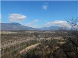
 | Globoko - Zjavka
Zjavka is a viewpoint above Kamna Gorica from which a beautiful panorama opens onto Kamna Gorica and part of the Lipniška Valley. At the viewpoin...
30 min |
 | Mišače - Zjavka
Zjavka is a viewpoint above Kamna Gorica from which a beautiful panorama opens onto Kamna Gorica and part of the Lipniška Valley. At the viewpoin...
40 min |
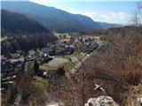
 | Globoko - Ojstra peč
Ojstra peč is a panoramic rocky promontory between the Lipniška Valley and the Sava River valley at Globoko, dropping steeply toward the fields a...
35 min |
| Globoko - Ojstra peč (via Zjavka)
Ojstra peč is a panoramic rocky promontory between the Lipniška Valley and the Sava River valley at Globoko, dropping steeply toward the fields a...
40 min |
 | Suhadole - Debeli vrh (above Topole)
Debeli vrh is a forest-covered peak located between the settlements of Koseze and Topole. On the summit there is a small wooden cross attached to...
30 min |
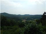 | Povir - Gura
Gura is a 510-meter-high hill located above Povir. From the summit, where the Church of the Assumption of Mary stands, there is a beautiful view ...
35 min |
 | PC Todraž - Sveti Urban (above Gorenja Dobrava)
The Church of St. Urban is located on a hill between Gorenja Dobrava and Todraž. From the summit, where there is a summit register box with a log...
25 min |
 | RC Korant - Ajdovščina nad Ihanom (on cart track)
Ajdovščina above Ihan is a hill covered in mixed forest, north of Dol pri Ljubljani. Several footpaths and cart tracks lead to the top. In summer...
25 min |
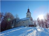
 | Vojnik - Sveti Tomaž above Vojnik (direct way)
Sv. Tomaž is a church on a partly vegetated 444 m high summit near Vojnik. There is a logbook with a stamp at the top. Below the summit stands th...
30 min |
 | Temnica - Sveti Ambrož (Tabor) (western path)
Sveti Ambrož (or Tabor) is a hill on the Karst above the villages of Temnica and Lipa. On the summit are the remains of the former St. Ambrož Chu...
45 min |
 | Srednja vas-Poljane - Church of the Holy Cross at Brezje above Srednja vas (on footpath)
The Church of the Holy Cross at Brezje above Srednja vas is situated on a hill above the left bank of the Poljanska Sora River. From the church, ...
25 min |
| Dobje - Church of the Holy Cross at Brezje above Srednja vas
The Church of the Holy Cross at Brezje above Srednja vas is situated on a hill above the left bank of the Poljanska Sora River. From the church, ...
25 min |
 | Podgrad - Murjevka
Murjevka is a 443-meter-high peak above the valley of the Besnica stream, south of Podgrad. The summit is located in the forest so it doesn't off...
40 min |
 | Church of St. Lovrenc above Dragomer - Vrhovčev grič
Vrhovčev grič is an indistinct, forested peak located just a few meters off the marked trail between Debeli hrib and Strmca....
30 min |
 | Brezje pri Dobrovi - Vrhovčev grič (via Strmca)
Vrhovčev grič is an indistinct, forested peak located just a few meters off the marked trail between Debeli hrib and Strmca....
45 min |
 | Dragomer (bajer) - Strmec (above Dragomer) (past Ferjanka)
Strmec is a distinct, forest-covered peak situated between Dragomer and Log. Numerous logging trails lead to the top. It is located south of the ...
30 min |
 | Dragomer (OŠ Log-Dragomer) - Strmec (above Dragomer)
Strmec is a distinct, forest-covered peak situated between Dragomer and Log. Numerous logging trails lead to the top. It is located south of the ...
30 min |
 | Ljubljana (Rakovnik) - Luknje
Luknje is a 438-meter-high peak in the northwestern part of Golovec. At the summit, where the forest educational point Planetarij is located, mod...
30 min |
 | Zlogonje - Vidikovac Vukovoj
Vidikovac Vukovoj is located on the eastern part of Ravna Gora. Built in 2025, it quickly became extremely popular among visitors and hikers from...
45 min |