 | Srednja vas - Viševnik (Za Ribnico and over Gola Ravan)
Viševnik is a 2050 m high mountain rising northwest of Rudno polje on Pokljuka. From the summit, where there is a stamp, a beautiful view opens o...
4 h 35 min |
 | Srednja vas - Viševnik (behind Ribnica and via source of Zlata voda)
Viševnik is a 2050 m high mountain rising northwest of Rudno polje on Pokljuka. From the summit, where there is a stamp, a beautiful view opens o...
4 h 40 min |
 | Kraljev hrib - Rzenik (west path)
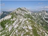
Rzenik is a grassy peak surrounded by dwarf pines that drops precipitously into the Kamniška Bela valley. From the summit, in clear weather, a wo...
3 h 40 min |
 | Potoče - Srednji vrh (via Sveti Jakob, below Potoška gora and over Baba)
Srednji vrh is an 1853 m high mountain located east of Storžič. From the summit, which features a bench, registration box and stamp, there is a b...
4 h 45 min |
| Spodnja Kokra - Srednji vrh (via Baba)
Srednji vrh is an 1853 m high mountain located east of Storžič. From the summit, which features a bench, registration box and stamp, there is a b...
4 h 5 min |
 | Mače - Bašeljski vrh (via valley of Suha and via Kališče)
Bašeljski vrh is a 1744-meter-high mountain located between Mali Grintovec and Storžič. From the summit, where there is a bench and a registratio...
3 h 25 min |
 | Rosenbach - Frauenkogel/Dovška Baba (via Hruški vrh)
Dovška Baba is a 1891-meter-high peak located on the border ridge between Slovenia and Austria. From the summit, which has a registration box and...
4 h 40 min |
| Rosenbach - Frauenkogel/Dovška Baba (via Koprivnjak)
Dovška Baba is a 1891-meter-high peak located on the border ridge between Slovenia and Austria. From the summit, which has a registration box and...
4 h 30 min |
 | Ribčev Laz - Rodica (via Lepa Suha)
The mountain Rodica is located above Bohinj in the Lower Bohinj Mountains. From the summit there is a beautiful view over the Julian Alps and the...
4 h |
 | Stara Fužina - Ogradi
Ogradi is located between the Laz and Krstenica mountain pastures. The summit is grassy with plenty of space. A small cross stands on the top. Fr...
5 h 20 min |
 | Rosenbach - Klek
Klek is a 1753-metre-high mountain located between Hruški vrh and the better-known Golica. The summit, on the border between Slovenia and Austria...
3 h 40 min |
 | Mojstrana - Drobeče Sleme
Drobeče Sleme is situated on the same ridge as the better-known Sleme. On this panoramic summit, from which Kukova Špica and Špik are nicely visi...
4 h 15 min |
 | Mojstrana - Vrtaški vrh (old path)
Vrtaški Vrh is a panoramic mountain above Vrata Valley. From the grassy peak, surrounded by dwarf pines, there is a nice view toward the neighbor...
3 h 30 min |
 | Potoče - Cjanovca (via Sveti Jakob, below Potoška gora and over Baba)
Cjanovca is a peak east of Storžič and south of Srednji vrh. It is clearly visible from Kranj and its surroundings. The southern slope is bare, w...
4 h 30 min |
| Spodnja Kokra - Cjanovca (via Baba)
Cjanovca is a peak east of Storžič and south of Srednji vrh. It is clearly visible from Kranj and its surroundings. The southern slope is bare, w...
3 h 50 min |
 | Koča pri Savici - Velika Baba (via Velika Montura)
Velika Baba is the highest peak of the eastern ridge above Lepena valley. From the summit, which has a logbook, there are fine views of Krn and L...
5 h 35 min |
 | Zadnjica - Zadnjiški Ozebnik
Zadnjiški Ozebnik is a little-known mountain above Zadnjica valley. As no marked trail leads to the summit, it offers peace at the top. It provid...
4 h 15 min |
| Trenta - Zadnjiški Ozebnik
Zadnjiški Ozebnik is a little-known mountain above Zadnjica valley. As no marked trail leads to the summit, it offers peace at the top. It provid...
4 h 15 min |
 | Kneške Ravne - Vrh Planje (above Globoko)
Vrh Planje is a less prominent peak in the ridge of the Lower Bohinj Mountains, which has been increasingly visited lately. Vrh Planje (above Glo...
4 h 30 min |
| Ukanc - Vrh Planje (above Globoko) (via Globoko)
Vrh Planje is a less prominent peak in the ridge of the Lower Bohinj Mountains, which has been increasingly visited lately. Vrh Planje (above Glo...
4 h |
 | Koča pri Savici - Vrh Škrli
Vrh Škrli is a 1,926-meter-high mountain located above the Spodnja Komna plateau. From its grassy summit, over which the national border once ran...
4 h 30 min |
 | Stara Fužina - Krsteniški Stog (čez Krsteniški preval)
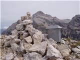
Krsteniški Stog, or Mali Stog, is a 1879 m high mountain rising steeply above the Krstenica mountain pasture. From the summit, where a stone cair...
4 h 15 min |
 | Petrovo Brdo - Rušni vrh
Rušni vrh is a 1,786-meter-high peak located east of Črna Prst. From the summit, which features a border stone from the old Rapallo border, a bea...
4 h 30 min |
| Podbrdo - Rušni vrh (via Vrh Bače)
Rušni vrh is a 1,786-meter-high peak located east of Črna Prst. From the summit, which features a border stone from the old Rapallo border, a bea...
4 h 30 min |
| Bohinjska Bistrica - Rušni vrh (via Planina za Črno goro)
Rušni vrh is a 1,786-meter-high peak located east of Črna Prst. From the summit, which features a border stone from the old Rapallo border, a bea...
3 h 50 min |
 | Luče - Kup (on Raduha)
Kup is a 1,808-meter-high peak situated on the far northeastern part of Raduha. From the summit, where a cross stands, a beautiful view opens up ...
4 h 5 min |
 | Kranjska Gora - Visoka peč (via Bedančev dom)
Visoka peč is a 1,749-meter-high mountain located southwest of Ciprnik. From its summit, which steeply descends towards Planica and features a sm...
3 h 25 min |
 | Ombrico - Monte Gosadon
Monte Gosadon is a somewhat less-visited peak in the Naborjet Mountains group. The surroundings of the peak also feature quite a few remains from...
3 h 40 min |
 | Hirschegg - Peterer Riegel (by grazing fence)
Peterer Riegel is a panoramic peak above the Peterer Sattel saddle. From the summit, where a cross stands and a bench sits below it, a beautiful ...
4 h 5 min |
 | Hirschegg - Peterer Riegel (via Peterer Alm)
Peterer Riegel is a panoramic peak above the Peterer Sattel saddle. From the summit, where a cross stands and a bench sits below it, a beautiful ...
4 h 10 min |
 | parking lot Hoyer (Neuhofgraben) - Speikkogel (Gleinalpe) (via Kreuzsattel)
Speikkogel lies northwest of Graz and, at 1988 m, is the second highest peak of the Gleinalpe.The European path E6 and the Austrian Central Alpin...
4 h 10 min |
 | parking lot Hoyer (Neuhofgraben) - Lenzmoarkogel (Gleinalpe) (via Kreuzsattel)
Lenzmoarkogel is located northwest of Gradec and, at 1991 meters above sea level, is the highest peak of the Gleinalpe (Glinska planina).The thre...
4 h 25 min |
 | Aflenz Kurort (Freibad Aflenz) - Hochstein (at Mitteralm) (via Windgrube)
Hochstein is a scenic summit with a cross and summit register box in the Hochschwab mountain group, between Windgrube peak and the Mitteralm plat...
3 h 35 min |