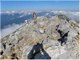
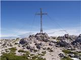
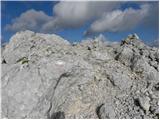
 | Trate / Johannsenruhe - Hochstuhl/Stol (climbing way)
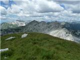
Stol is, at 2,236 m, the highest peak in the Karawanks. From the summit, which has a registration box and stamp, a beautiful view opens onto the ...
3 h 20 min |
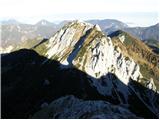 | Ljubelj - Veliki vrh (Košuta) (via Koča na Ljubelju)
Veliki Vrh, at 2,088 m, is the westernmost two-thousander in Slovenia's longest ridge, the Košuta. From the summit, which has a registration box ...
3 h 50 min |
| Bučan - Veliki vrh (Košuta)
Veliki Vrh, at 2,088 m, is the westernmost two-thousander in Slovenia's longest ridge, the Košuta. From the summit, which has a registration box ...
3 h 50 min |
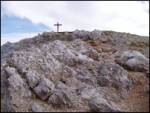 | Dom pod Storžičem - Storžič (through Žrelo)
Storžič is a 2132 m high mountain located in the western part of the Kamnik-Savinja Alps. From the summit, where there is a cross, a beautiful vi...
3 h |
 | Dom pod Storžičem - Storžič (via Psica)
Storžič is a 2132 m high mountain located in the western part of the Kamnik-Savinja Alps. From the summit, where there is a cross, a beautiful vi...
3 h 45 min |
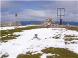
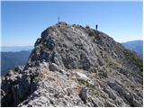 | Koschutahaus - Koschutnikturm (Košutnikov turn) (ÖTK Steig Neu)
Košutnikov Turn is the highest peak in Košuta, the longest Slovenian ridge. The summit offers a beautiful view of the entire ridge. Austria and t...
2 h 45 min |
 | Ravenska Kočna - Ledinski vrh (Slovenian way)
The mountain is located above Jezersko and lies on the border with Austria. From the summit there is a beautiful view north towards the neighbour...
3 h 15 min |
| Ravenska Kočna - Ledinski vrh (via Žrelo)
The mountain is located above Jezersko and lies on the border with Austria. From the summit there is a beautiful view north towards the neighbour...
3 h 15 min |
 | Koča pod slapom Rinka - Mrzla gora
This difficult-to-access mountain is located on the border with Austria in the Kamnik-Savinja Alps. From the summit there is a beautiful view tow...
4 h 30 min |
 | Nassfeld - Creta di Aip / Trogkofel (Uiberlacher Steig)
Veliki Koritnik / Creta di Aip / Trogkofel is the highest peak in the Mokrine / Nassfeld pass area. The mountain has a gentle summit from which s...
4 h 30 min |
| Nassfeld - Creta di Aip / Trogkofel (Via Ferrata Crete Rosse)
Veliki Koritnik / Creta di Aip / Trogkofel is the highest peak in the Mokrine / Nassfeld pass area. The mountain has a gentle summit from which s...
4 h 30 min |
 | Cason di Lanza - Creta di Aip / Trogkofel (ferrata Crete Rose)
Veliki Koritnik / Creta di Aip / Trogkofel is the highest peak in the Mokrine / Nassfeld pass area. The mountain has a gentle summit from which s...
3 h 30 min |
 | Parking place below Nassfeld - Monte Cavallo / Rosskofel (by east ridge)
Konjski Špik / Monte Cavallo di Pontebba / Rosskofel is a 2,240-meter-high and highly panoramic mountain in the main ridge of the Carnic Alps in ...
3 h 30 min |
 | Planina Zajzera - Jof di Miezegnot/Poldašnja špica
Poldašnja špica is the easternmost two-thousander in the Malborghetto mountains group (Monti di Malborgheto). From the mountain, which has many r...
3 h |
 | Rudnik v Topli - Petzen (Kordeschkopf) (Peca (Kordeževa glava)) (via Dom na Peci - climbing way)
Kordeževa glava, better known as Peca, is the highest peak of the Peca range. It is located on the border with Austria above the Mežiška dolina v...
3 h 30 min |
| Koča na Pikovem - Petzen (Kordeschkopf) (Peca (Kordeževa glava)) (over saddle Vrh šteng and on climbing way)
Kordeževa glava, better known as Peca, is the highest peak of the Peca range. It is located on the border with Austria above the Mežiška dolina v...
3 h 45 min |
 | Ravenska Kočna - Velika (Koroška) Baba (on Slovenska and climbing way)
Velika (Koroška) Baba is a 2127 m high mountain on the border ridge above the Ravenska Kočna valley on the Slovenian side and above the Bela (Bel...
3 h 45 min |
| Ravenska Kočna - Velika (Koroška) Baba (on Slovenska pot and over Jezersko sedlo)
Velika (Koroška) Baba is a 2127 m high mountain on the border ridge above the Ravenska Kočna valley on the Slovenian side and above the Bela (Bel...
4 h 15 min |
| Ravenska Kočna - Velika (Koroška) Baba (through Žrelo and on climbing way)
Velika (Koroška) Baba is a 2127 m high mountain on the border ridge above the Ravenska Kočna valley on the Slovenian side and above the Bela (Bel...
3 h 45 min |
| Ravenska Kočna - Velika (Koroška) Baba (on hunting and climbing path)
Velika (Koroška) Baba is a 2127 m high mountain on the border ridge above the Ravenska Kočna valley on the Slovenian side and above the Bela (Bel...
4 h |
| Ravenska Kočna - Velika (Koroška) Baba (through Žrelo and over Jezersko sedlo)
Velika (Koroška) Baba is a 2127 m high mountain on the border ridge above the Ravenska Kočna valley on the Slovenian side and above the Bela (Bel...
4 h 15 min |
 | Planina Kuk - Vrh nad Škrbino (via Škrbina)
Vrh nad Škrbino is the easternmost two-thousander in the ridge of the Lower Bohinj Mountains. From the summit, there are excellent views of the n...
3 h 45 min |
| Ski hotel Vogel - Vrh nad Škrbino
Vrh nad Škrbino is the easternmost two-thousander in the ridge of the Lower Bohinj Mountains. From the summit, there are excellent views of the n...
4 h 50 min |
 | Ski hotel Vogel - Vrh nad Škrbino (on Bohinj Mountain Trail)
Vrh nad Škrbino is the easternmost two-thousander in the ridge of the Lower Bohinj Mountains. From the summit, there are excellent views of the n...
4 h 30 min |
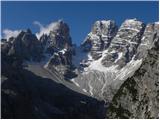
 | Pecol - Cima di Terrarossa (Leva)
Špik Hude police is a 2431-meter-high panoramic peak (new LiDAR measurement; this height will also be shown on newer maps, while older maps still...
4 h 30 min |
 | Ski hotel Vogel - Meja (on Bohinj mountain trail and over Vrh nad Škrbino)
Meja is a nearly 2,000-meter peak in the heart of the Lower Bohinj Mountains, specifically between Vrh nad Škrbino and Vogel. From this little-vi...
4 h 50 min |
 | Koča pod slapom Rinka - Vellacher Turm/Storžek
Storžek (or Belski turn) is a 2,110-meter-high mountain on the Austrian side of Jezersko sedlo. The summit, which is not marked on most Slovenian...
3 h 45 min |
 | Lienzer Dolomitenhütte - Große Gamswiesenspitze (Normalweg)
Große Gamswiesenspitze is a 2,488-meter-high mountain located in the heart of the Lienz Dolomites. From the summit, which features a summit logbo...
3 h 30 min |
 | Lienzer Dolomitenhütte - Kleine Gamswiesenspitze
Kleine Gamswiesenspitze is a steep and sharp mountain located near the larger Große Gamswiesenspitze. From its precipitous summit, there is a bea...
3 h 30 min |
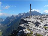
 | Plockenpass - Creta di Collinetta / Cellon (Via ferrata Steinberger Weg)
Creta di Collinetta / Cellon is a 2,238-meter-high mountain located west of the Plöcken Pass. From the summit, which features a cross, there is a...
3 h |
 | Pecol - Foronon del Buinz / Špik nad Nosom (Ceria Merlone)
Špik nad Nosom is a 2,531 m high mountain located in the ridge between Montaž and Viš. From its rocky summit on a clear day, views open up to the...
3 h 45 min |
 | Carbonin - Monte Fumo / Rauhkofel
Monte Fumo / Rauhkofel is a 2114-meter-high mountain in the Cristallo group. From the summit, located right next to the group's highest peaks, th...
2 h 45 min |
 | Landro - Monte Piano (Via Ferrata Bilgeri)
Monte Piano (Toblacher Kreuz) is a 2,305-meter-high mountain located on the northwestern edge of the Monte Piana plateau. Near the summit there a...
3 h |
 | Planina Zajzera - Monte Gosadon
Monte Gosadon is a somewhat less-visited peak in the Naborjet Mountains group. The surroundings of the peak also feature quite a few remains from...
4 h 10 min |
 | Planina Zajzera - Visoki Pipar / Monte Piper
Visoki Pipar or Italian Monte Piper is, with 2069 meters, the highest and most easily accessible peak in the Pipar ridge in the Naborje mountains...
3 h 40 min |
 | Karnica / Sella Carnizza - Monte Musi (western peak)
Vrh Muzcev (western peak) is located in the central part of the Muzcev Ridge, separating Rezija Valley and Terska Valley. Its 1,864-meter summit,...
3 h 30 min |