 | The Krma Valley - Triglav (via Kredarica)
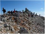
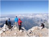
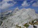
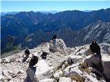
Triglav is a 2,864 m high mountain located in the heart of the Julian Alps. At this altitude, it is the highest mountain in Slovenia and also the...
6 h 15 min |
| The Krma Valley - Triglav (via Planika and Mali Triglav)
Triglav is a 2,864 m high mountain located in the heart of the Julian Alps. At this altitude, it is the highest mountain in Slovenia and also the...
6 h |
 | The Krma Valley - Triglav (via Planika and Triglavska škrbina)
Triglav is a 2,864 m high mountain located in the heart of the Julian Alps. At this altitude, it is the highest mountain in Slovenia and also the...
5 h 55 min |
| Stara Fužina - Triglav (via Planika and Mali Triglav)
Triglav is a 2,864 m high mountain located in the heart of the Julian Alps. At this altitude, it is the highest mountain in Slovenia and also the...
7 h 50 min |
 | Zadnjica - Triglav (via Plemenice)
Triglav is a 2,864 m high mountain located in the heart of the Julian Alps. At this altitude, it is the highest mountain in Slovenia and also the...
7 h 20 min |
 | Zadnjica - Triglav (via Dolič)
Triglav is a 2,864 m high mountain located in the heart of the Julian Alps. At this altitude, it is the highest mountain in Slovenia and also the...
7 h 30 min |
 | Koča pri Savici - Triglav (via Triglavska jezera)
Triglav is a 2,864 m high mountain located in the heart of the Julian Alps. At this altitude, it is the highest mountain in Slovenia and also the...
8 h 55 min |
| Stara Fužina - Triglav (via Planika and Triglavska škrbina)
Triglav is a 2,864 m high mountain located in the heart of the Julian Alps. At this altitude, it is the highest mountain in Slovenia and also the...
7 h 45 min |
| Zadnjica - Triglav (via Komar)
Triglav is a 2,864 m high mountain located in the heart of the Julian Alps. At this altitude, it is the highest mountain in Slovenia and also the...
7 h 10 min |
| Srednja vas - Triglav (Za Ribnico and via Triglavska škrbina)
Triglav is a 2,864 m high mountain located in the heart of the Julian Alps. At this altitude, it is the highest mountain in Slovenia and also the...
8 h 5 min |
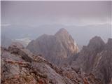 | Zadnjica - Škrlatica
Škrlatica is the second highest mountain in Slovenia. A cross stands on the summit, making it easily recognisable from neighbouring peaks. It als...
8 h 55 min |
| Pišnica - Škrlatica (via Kriška stena)
Škrlatica is the second highest mountain in Slovenia. A cross stands on the summit, making it easily recognisable from neighbouring peaks. It als...
8 h 25 min |
 | The Krma Valley - Mali Triglav (via Kredarica)
Mali Triglav is an indistinct summit on the main ridge of Triglav. Despite its considerable height, it is rarely chosen as an independent objecti...
5 h 40 min |
| The Krma Valley - Mali Triglav (past Doma Planika pod Triglavom)
Mali Triglav is an indistinct summit on the main ridge of Triglav. Despite its considerable height, it is rarely chosen as an independent objecti...
5 h 25 min |
 | Zadnja Trenta (Flori) - Jalovec (via Jalovška škrbina)
At 2,645 m, Jalovec is the sixth highest mountain in Slovenia. The summit drops steeply towards three alpine valleys (Loška Koritnica, Tamar, and...
5 h 40 min |
| Zadnja Trenta (Flori) - Jalovec (via Zavetišče pod Špičkom)
At 2,645 m, Jalovec is the sixth highest mountain in Slovenia. The summit drops steeply towards three alpine valleys (Loška Koritnica, Tamar, and...
5 h 45 min |
 | NC Planica - Jalovec (past bivouac and Kotovo sedlo)
At 2,645 m, Jalovec is the sixth highest mountain in Slovenia. The summit drops steeply towards three alpine valleys (Loška Koritnica, Tamar, and...
6 h 10 min |
| Bavšica - Jalovec
At 2,645 m, Jalovec is the sixth highest mountain in Slovenia. The summit drops steeply towards three alpine valleys (Loška Koritnica, Tamar, and...
7 h 35 min |
| NC Planica - Jalovec (on scree and over Kotovo sedlo)
At 2,645 m, Jalovec is the sixth highest mountain in Slovenia. The summit drops steeply towards three alpine valleys (Loška Koritnica, Tamar, and...
6 h 10 min |
 | Zadnjica - Razor
The summit of Razor lies above the alpine valley of Mlinarica. Though not spacious, it offers a superb view. All the peaks above the Kriški podi ...
6 h |
 | Pišnica - Dolkova špica (via Kriška stena)
Dolkova špica is a 2,591 m high mountain situated between Stenar and Škrlatica. From the summit, which has a registration box, a beautiful panora...
6 h 35 min |
 | Korito / Coritis - Visoki Kanin (Via ferrata Rosalba Grasselli)
Visoki Kanin is the highest peak of the Kanin mountains. From the summit, which has a cross, there is a nice view of the western Julian Alps, and...
6 h 50 min |
 | V Koncu - Grintovec (via Kokrsko and Mlinarsko sedlo)
Grintovec is the highest peak of the Kamnik-Savinja Alps. It is located above the Kamniška Bistrica Valley, Suhi Dol, and the Ravenska Kočna Vall...
5 h 30 min |
| Suhadolnik - Grintovec (via Kokrsko and Mlinarsko sedlo)
Grintovec is the highest peak of the Kamnik-Savinja Alps. It is located above the Kamniška Bistrica Valley, Suhi Dol, and the Ravenska Kočna Vall...
5 h 45 min |
 | Suhadolnik - Jezerska Kočna (via Grdi graben and Dolci)
Jezerska Kočna is located west of Grintovec. From the summit, there is a very nice view towards Grintovec. The Karawanks and the Gorenjska plain ...
5 h 15 min |
| Suhadolnik - Jezerska Kočna (via Kokrsko sedlo and Dolci)
Jezerska Kočna is located west of Grintovec. From the summit, there is a very nice view towards Grintovec. The Karawanks and the Gorenjska plain ...
6 h 15 min |
| V Koncu - Jezerska Kočna (via Dolci)
Jezerska Kočna is located west of Grintovec. From the summit, there is a very nice view towards Grintovec. The Karawanks and the Gorenjska plain ...
6 h |
 | V Koncu - Jezerska Kočna (via Kokrska Kočna)
Jezerska Kočna is located west of Grintovec. From the summit, there is a very nice view towards Grintovec. The Karawanks and the Gorenjska plain ...
6 h |
| Suhadolnik - Jezerska Kočna (via Grdi graben and Kokrska Kočna)
Jezerska Kočna is located west of Grintovec. From the summit, there is a very nice view towards Grintovec. The Karawanks and the Gorenjska plain ...
5 h 15 min |
| Suhadolnik - Jezerska Kočna (via Kokrsko sedlo and Kokrska Kočna)
Jezerska Kočna is located west of Grintovec. From the summit, there is a very nice view towards Grintovec. The Karawanks and the Gorenjska plain ...
6 h 15 min |
 | Dolina Krma - Rjavina (ridge path)
Rjavina is located between two alpine valleys, Kot and Krma. From the summit, which has a logbook, there is a very nice view towards Triglav, Rž,...
6 h 45 min |
 | Suhadolnik - Kokrska Kočna (via Kokrsko sedlo)
Kokrska Kočna is a panoramic and spacious mountain between Jezersko and Suhadolnik. From the summit, which has a logbook box, there is a very nic...
5 h 45 min |
| V Koncu - Kokrska Kočna
Kokrska Kočna is a panoramic and spacious mountain between Jezersko and Suhadolnik. From the summit, which has a logbook box, there is a very nic...
5 h 30 min |
 | Pišnica - Stenar (via Križ)
Stenar is a 2,501-meter-high peak that rises steeply above the Vrata Valley. From the spacious summit, which has a logbook box and a stamp, a bea...
6 h 55 min |
 | V Koncu - Dolgi hrbet (via Kokrsko sedlo)
Dolgi Hrbet lies between Grintovec and Skuta. From its precipitous summit there is a fine view across the heart of the Kamnik-Savinja Alps. Dolgi...
5 h |
 | Pišnica - Špik (via Koča v Krnici)
Špik is a 2,472 m high mountain situated in the heart of the Martuljek group. From the summit, clearly visible from the road through Gozd Martulj...
5 h 30 min |
 | V Koncu - Brana (via Turska gora)
Brana is a mountain above Kamniško sedlo. From the spacious summit, which has a registration box and a small cross, there is a very beautiful vie...
5 h 45 min |
 | Drežnica - Krn (Silvo Koren route)
Krn, at 2244 m, is the highest peak of the Krn mountain group, which rises steeply above the central part of the Soča River. From the summit, fea...
5 h |
 | Pišnica - Križ
Križ is a 2,140 m high mountain located northeast of the Kriški Podi plateau. The summit, which has a registration box with a stamp, offers a bea...
5 h 25 min |
 | Suhadolnik - Turska gora
The mountain is located above Logarska dolina and the Kamniška Bistrica valley. From the summit, there is a beautiful view of the neighboring pea...
6 h 15 min |
 | Korito / Coritis - Vrh Krnice
Vrh Krnice is a 2,441-meter-high peak located northwest of Visoki Kanin. From the summit, where there is usually an empty logbook box, there is a...
5 h 50 min |
 | Parking Alpspitzbahn - Alpspitze (Alpspitz Ferrata)
Alpspitze is a 2628-meter-high peak in the Wetterstein mountain group. From the summit, where a cross from 1946 stands, there is a very nice view...
6 h 15 min |
 | Cellino di Sopra - Col Nudo
Col Nudo is the main mountain in the southwestern part of the Carnic Prealps, on the border between Veneto and Friuli-Venezia Giulia. It offers n...
6 h 30 min |
 | Railway station Hochzirl - Kleiner Solstein (on Höttinger Schützensteig)
Kleiner Solstein is the highest peak of the famous Nordkette ridge, which blocks views from the valley to the central part of the Karwendel range...
6 h |
 | Pišnica - Lipnica (via Koča v Krnici)
Lipnica is a high-mountain peak standing in the immediate vicinity of Špik and representing its southern neighbour. It lies on the ridge that des...
4 h 55 min |