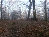
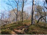
 | Jevnica - Janče
Janče is a 792-meter-high peak situated between the Sava River and the Besnica stream valley. From the summit, where a mountain hut stands and th...
1 h 45 min |
 | Breg - Sveti Lovrenc (above Okroglice)
The Church of St. Lovrenc is located east of Zidani Most and northwest of Sevnica, above the village of Okroglice and near the Lovrenc peak. From...
1 h 45 min |
| Dolina Gračnice (Blatnik) - Sveti Lovrenc (above Okroglice)
The Church of St. Lovrenc is located east of Zidani Most and northwest of Sevnica, above the village of Okroglice and near the Lovrenc peak. From...
1 h 45 min |
 | Rimske Toplice - Dom v Gorah (via Ogeški potok)
The Dom v Gorah mountain hut is located east of Hrastnik, just a few meters below the 786 m high peak where the church of St. Jurij stands. From ...
2 h 40 min |
 | Laško - Dom na Šmohorju
The mountain lodge on Šmohor is located on a picturesque and scenic ridge between Laško, Liboje and Zabukovica. The lodge, a popular spot for bot...
2 h |
 | Tremerje - Dom na Šmohorju
The mountain lodge on Šmohor is located on a picturesque and scenic ridge between Laško, Liboje and Zabukovica. The lodge, a popular spot for bot...
2 h 15 min |
 | Gradišče pri Vipavi - Gradiška Tura (via Plaz)
Gradiška Tura is a prominent 754-meter peak rising at the far western edge of the Nanos plateau directly above the Vipava Valley. Thanks to its e...
2 h |
 | Zamedveje - Korada
Korada is a panoramic peak west of the Soča River and on the northern edge of Goriška Brda. From the summit, which has a summit logbox, there is ...
2 h 30 min |
 | Tremerje - Veliki Slomnik (Tremerje - Veliki Slomnik - Liboje)
Veliki Slomnik is a peak located between Košnica pri Celju and Liboje. The summit has a logbook box, but due to the surrounding forest, there are...
1 h 35 min |
 | Tremerje - Hom above Celje (via crossing Slomnik)
Hom is a forest-covered peak located north of Košnica pri Celju. The summit features a logbook box and a small bench....
2 h 20 min |
 | Štore - Resevna
Resevna is a peak situated south of Šentjur. At the summit stands a 20-meter-high observation tower offering beautiful views that extend far acro...
2 h 30 min |
 | Zagrad - Grmada above Celje (gentle path)
What Šmarna gora is to people from Ljubljana, Grmada is to those from Celje. Celje's local mountain lies south of the town above Zagrad village. ...
1 h 30 min |
 | Štore - Srebotnik
Srebotnik is a slightly vegetated peak located south of Celje and Štore in the Posavsko hribovje. The summit, which has a logbook box and a small...
1 h 30 min |
 | Štore - Srebotnik (via Marija and south approach)
Srebotnik is a slightly vegetated peak located south of Celje and Štore in the Posavsko hribovje. The summit, which has a logbook box and a small...
1 h 45 min |
 | Teharje - Srebotnik (Pot I. Celjske čete)
Srebotnik is a slightly vegetated peak located south of Celje and Štore in the Posavsko hribovje. The summit, which has a logbook box and a small...
2 h |
 | Laško (cemetery Laško) - Govško brdo
Govško brdo is an 811-meter-high hill located west of the village of Huda Jama above Laško. From the summit, which features a logbook box and sta...
2 h 35 min |
 | Seljanec - Ham (via Seljanečki potok)
Ham is an isolated peak beside the Ivanščica range, above the Bednja river valley. It is separated from Ivanščica by the Železnice stream valley,...
1 h 30 min |
 | Bela - Čevo
Čevo is the eastern peak on Ivanščica. From the south it is a gentle hill, but from the north it descends very steeply into the valley. It is als...
1 h 45 min |
 | Štore - Veliki vrh above Svetina (via Žlajfa and via Svetina)
Veliki vrh lies southwest of the settlement of Svetina above Štore. It is settled high up mainly from the south side, with one homestead directly...
2 h 15 min |
 | Štore - Veliki vrh above Svetina (through Bojanski graben and over Svetina)
Veliki vrh lies southwest of the settlement of Svetina above Štore. It is settled high up mainly from the south side, with one homestead directly...
2 h 30 min |
 | Štore - Resje above Štore (via Resevna)
Resje is a peak located directly along the mountain trail between Resevna to the east and Ramanca or Almin dom above Svetina to the west. It lies...
2 h |
 | Štore - Resje above Štore (via Žlajfa and via Vrunčev dom)
Resje is a peak located directly along the mountain trail between Resevna to the east and Ramanca or Almin dom above Svetina to the west. It lies...
2 h 30 min |
 | Studenice - Plešivec (at Boč)
Peace, silence, varied terrain... these are characteristics of the peak at the crossroads of numerous paths between the Maribor, Celje, and Ptuj ...
2 h |
 | Studenice - Plešivec (at Boč) (final part on forest road)
Peace, silence, varied terrain... these are characteristics of the peak at the crossroads of numerous paths between the Maribor, Celje, and Ptuj ...
2 h |
 | Naraplje - Jelovice
Jelovice, at 623 meters, is the highest peak in the Haloze hills. The summit is accessible from several directions. It offers partial views towar...
1 h 40 min |
| Stogovci (Vabča vas) - Jelovice
Jelovice, at 623 meters, is the highest peak in the Haloze hills. The summit is accessible from several directions. It offers partial views towar...
1 h 40 min |
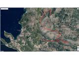 | Zvekovica - Stražišće (by road)
Stražišće is a peak rising above Cavtat, offering a magnificent view of Cavtat, Konavle and Dubrovnik.A cross stands on the summit in memory of t...
2 h |
 | Railway station (Most na Soči) - Viewpoint Široko
The viewpoint lies at 755 m above Most na Soči in the namesake hamlet of Tolminski Lom. Access is possible by car to the nearby tourist farm or o...
1 h 40 min |
 | Stogovci (Vabča vas) - Kerješetov vrh
Kerješetov vrh is a 590-meter-high hill located above the settlement of Jelovice. The summit is overgrown with forest, so there is no good view f...
1 h 30 min |
 | Radoboj - Sekolje (Strahinjčica)
Sekolje is the easternmost peak of Strahinjčica. It appears as an interesting cone shape from the surrounding areas. The view from the peak is li...
1 h 30 min |
 | Slake (Church of the Virgin Mary on Pesek) - Zavetišče Šmarnica on Mala Rudnica
The Šmarnica shrine is located on Mala Rudnica within the Rudnica range, a smaller hill chain above Podčetrtek. From the shrine there opens a bea...
1 h 35 min |
 | Podsreda - Veliki vrh (Orlica) (through Osredek pri Podsredi)
Veliki vrh is the highest point of the Orlica hills at 701 meters above sea level, stretching along the border between Posavje and Kozjansko and ...
1 h 45 min |
| Pišece (Pri mlinu) - Veliki vrh (Orlica)
Veliki vrh is the highest point of the Orlica hills at 701 meters above sea level, stretching along the border between Posavje and Kozjansko and ...
2 h 40 min |
 | Podsreda - Intermedija (through Osredek pri Podsredi)
Intermedija is a 662-meter-high peak in the Orlica range. From the summit, there is a beautiful view mainly to the north and northeast, where on ...
2 h 20 min |
| Pišece (Pri mlinu) - Intermedija
Intermedija is a 662-meter-high peak in the Orlica range. From the summit, there is a beautiful view mainly to the north and northeast, where on ...
1 h 50 min |
 | Čatež ob Savi - Veliki Cirnik
Veliki Cirnik, also known to some locals as Goli Cirnik, is the highest peak in the vicinity of Čatež ob Savi. At the summit, at a spot locals re...
2 h 15 min |