 | Gračnica - Sveti Lovrenc (above Okroglice) (past Mlinarič)
The Church of St. Lovrenc is located east of Zidani Most and northwest of Sevnica, above the village of Okroglice and near the Lovrenc peak. From...
3 h |
 | Laško - Dom na Šmohorju
The mountain lodge on Šmohor is located on a picturesque and scenic ridge between Laško, Liboje and Zabukovica. The lodge, a popular spot for bot...
2 h |
 | Tremerje - Dom na Šmohorju
The mountain lodge on Šmohor is located on a picturesque and scenic ridge between Laško, Liboje and Zabukovica. The lodge, a popular spot for bot...
2 h 15 min |
 | Gradišče pri Vipavi - Gradiška Tura (via Plaz)
Gradiška Tura is a prominent 754-meter peak rising at the far western edge of the Nanos plateau directly above the Vipava Valley. Thanks to its e...
2 h |
 | Zamedveje - Korada
Korada is a panoramic peak west of the Soča River and on the northern edge of Goriška Brda. From the summit, which has a summit logbox, there is ...
2 h 30 min |
 | Štore - Resevna
Resevna is a peak situated south of Šentjur. At the summit stands a 20-meter-high observation tower offering beautiful views that extend far acro...
2 h 30 min |
 | Štore - Resevna (via Žlajfa and via Resje nad Štorami)
Resevna is a peak situated south of Šentjur. At the summit stands a 20-meter-high observation tower offering beautiful views that extend far acro...
3 h 15 min |
 | Štore - Tolsti vrh above Celjska koča (via Žlajfa)
Tolsti vrh (also recorded as Tovsti vrh in some sources) is situated above the Celjska koča ski area. The summit has a logbook box and stamp, but...
2 h 15 min |
 | Štore - Tolsti vrh above Celjska koča (via Bojanski graben)
Tolsti vrh (also recorded as Tovsti vrh in some sources) is situated above the Celjska koča ski area. The summit has a logbook box and stamp, but...
2 h 30 min |
 | Štore - Tolsti vrh above Celjska koča (via Marija)
Tolsti vrh (also recorded as Tovsti vrh in some sources) is situated above the Celjska koča ski area. The summit has a logbook box and stamp, but...
2 h |
 | Teharje - Tolsti vrh above Celjska koča (via Srebotnik on CPP)
Tolsti vrh (also recorded as Tovsti vrh in some sources) is situated above the Celjska koča ski area. The summit has a logbook box and stamp, but...
3 h |
 | Podsreda - Veliki Špiček (through Osredek pri Podsredi)
Veliki Špiček is the highest peak of Brežice municipality. From the top a nice view spreads towards the south and east. Most of Brežice municipal...
2 h 45 min |
 | Senožeti - Murovica (via Vrh pri Dolskem)
Murovica is a popular excursion point, accessible from the Posavje side, Domžale, or the Moravška Valley. On the summit there is a bench and a lo...
2 h 5 min |
| Senožeti - Murovica (via farm Buven)
Murovica is a popular excursion point, accessible from the Posavje side, Domžale, or the Moravška Valley. On the summit there is a bench and a lo...
1 h 55 min |
 | Laško (cemetery Laško) - Govško brdo
Govško brdo is an 811-meter-high hill located west of the village of Huda Jama above Laško. From the summit, which features a logbook box and sta...
2 h 35 min |
 | Izlake - Pleše (via Grobovščica)
Pleše is an 866-meter-high peak situated between the Marela ski slope and Zasavska Sveta gora. From the summit, which features a NOB monument, th...
2 h 15 min |
 | Kozje - Oslica (Bohor) (via Vetrnik)
Oslica is one of Bohor's peaks, located in the eastern part of the range. Unlike some higher Bohor peaks such as Veliki Javornik, Koprivnik, Debe...
2 h 10 min |
 | Kozje - Brest (Bohor) (via Vetrnik)
Brest is a peak on Bohor, though it resembles more of a saddle. It is an important trail junction on Bohor, lying between more easterly Oslica an...
2 h |
 | Štore - Veliki vrh above Svetina (via Marija and over Svetina)
Veliki vrh lies southwest of the settlement of Svetina above Štore. It is settled high up mainly from the south side, with one homestead directly...
2 h 30 min |
 | Štore - Veliki vrh above Svetina (via Žlajfa and via Svetina)
Veliki vrh lies southwest of the settlement of Svetina above Štore. It is settled high up mainly from the south side, with one homestead directly...
2 h 15 min |
 | Štore - Veliki vrh above Svetina (through Bojanski graben and over Svetina)
Veliki vrh lies southwest of the settlement of Svetina above Štore. It is settled high up mainly from the south side, with one homestead directly...
2 h 30 min |
 | Gorica pri Slivnici - Žusem (Panoramska pot)
Žusem is a 669-meter-high hill with a rich history and great potential for the future. It forms the northern edge of Kozjansko, and its name deri...
3 h 20 min |
 | Studenice - Plešivec (at Boč)
Peace, silence, varied terrain... these are characteristics of the peak at the crossroads of numerous paths between the Maribor, Celje, and Ptuj ...
2 h |
 | Studenice - Plešivec (at Boč) (final part on forest road)
Peace, silence, varied terrain... these are characteristics of the peak at the crossroads of numerous paths between the Maribor, Celje, and Ptuj ...
2 h |
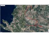 | Zvekovica - Stražišće (by road)
Stražišće is a peak rising above Cavtat, offering a magnificent view of Cavtat, Konavle and Dubrovnik.A cross stands on the summit in memory of t...
2 h |
 | Rimske Toplice - Vrhe (at Gore) (via Ogeški potok)
Vrhe is a forested 781-meter-high peak located northwest of the Planinski dom hut in Gore....
2 h 50 min |
 | Slake (Church of the Virgin Mary on Pesek) - Plešivec (Rudnica)
Plešivec is a forest-covered peak on Rudnica, its highest point. The summit has a summit register box, a bench, and a table....
2 h |
| Podčetrtek (Terme Olimia) - Plešivec (Rudnica) (past castle Podčetrtek)
Plešivec is a forest-covered peak on Rudnica, its highest point. The summit has a summit register box, a bench, and a table....
2 h 5 min |
 | Pásztó - Muzsla (path marked with green plus)
Muzsla (Mužlo) is the highest peak in the western part of the Mátra Mountains, which also include Hungary's highest peak Kékestető. A concrete to...
3 h 15 min |
 | Mošćenice - Kremenjak (past Kalvarija)
Kremenjak is a scenic rocky peak on Učka. The peak is a point on the Istrian Mountain Path. From the peak, which has a summit book box and a bord...
2 h 45 min |
| Mošćenice - Kremenjak (on marked path)
Kremenjak is a scenic rocky peak on Učka. The peak is a point on the Istrian Mountain Path. From the peak, which has a summit book box and a bord...
2 h 40 min |
 | Mošćenice - Planinsko zavetišče Kremenjak (past Kalvarija)
The Kremenjak Mountain Shelter is located on a small peak between Kremenjak and Brgud. The bivouac is of quite unusual shape and has some benches...
2 h 45 min |
| Mošćenice - Planinsko zavetišče Kremenjak (on marked path)
The Kremenjak Mountain Shelter is located on a small peak between Kremenjak and Brgud. The bivouac is of quite unusual shape and has some benches...
2 h 40 min |
 | Mošćenice - Brgud (past Kalvarija and Kremenjak)
Brgud is a scenic peak on Učka. The peak is a point of the Istrian Mountain Path. At the highest point of the peak, there is only a pile of stone...
3 h 15 min |
| Mošćenice - Brgud (along the marked trail and past Kremenjak)
Brgud is a scenic peak on Učka. The peak is a point of the Istrian Mountain Path. At the highest point of the peak, there is only a pile of stone...
3 h 10 min |
 | Pišece (Pri mlinu) - Veliki vrh (Orlica)
Veliki vrh is the highest point of the Orlica hills at 701 meters above sea level, stretching along the border between Posavje and Kozjansko and ...
2 h 40 min |
 | Čatež ob Savi - Veliki Cirnik
Veliki Cirnik, also known to some locals as Goli Cirnik, is the highest peak in the vicinity of Čatež ob Savi. At the summit, at a spot locals re...
2 h 15 min |