 | Dom Pristava in Javorniški Rovt - Barentaler Kotschna/Struška (čez Sedlo Kočna)
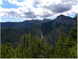
Struška is a smaller mountain range in the Karavanke ridge, located between Stol (specifically Belščica) and Golica. From Veliki vrh (1944 m), th...
3 h 15 min |
 | Mače - Bašeljski vrh (via valley of Suha and via Kališče)
Bašeljski vrh is a 1744-meter-high mountain located between Mali Grintovec and Storžič. From the summit, where there is a bench and a registratio...
3 h 25 min |
 | Rosenbach - Frauenkogel/Dovška Baba (via Koprivnjak)
Dovška Baba is a 1891-meter-high peak located on the border ridge between Slovenia and Austria. From the summit, which has a registration box and...
4 h 30 min |
| Dovje - Frauenkogel/Dovška Baba (via Blažčeva skala)
Dovška Baba is a 1891-meter-high peak located on the border ridge between Slovenia and Austria. From the summit, which has a registration box and...
3 h 15 min |
 | Smrečje - Plešivec (by road)
Plešivec is an 1801 m high peak situated south of the eastern part of Košuta. From the summit, where a border marker stands, there is a beautiful...
3 h 30 min |
 | Za Loncem - Deska (Veža)
Deska is a panoramic peak located in the heart of the Dleskovška planota plateau, also known as Veža. From the summit, where a large cairn stands...
3 h 30 min |
 | Za Loncem - Tolsti vrh (Veža)
Tolsti vrh is a 1985 m high mountain located in the heart of the Dleskovška planota plateau, known as Veža. From the summit, which is covered wit...
3 h 35 min |
 | Rosenbach - Klek
Klek is a 1753-metre-high mountain located between Hruški vrh and the better-known Golica. The summit, on the border between Slovenia and Austria...
3 h 40 min |
 | Gate (Belca) - Techantinger Mittagskogel (Trupejevo poldne) (by road)
The mountain is located on the border with Austria above Gozd Martuljek. From the bare summit, there is a beautiful view of the Julian Alps and t...
4 h |
| Srednji vrh - Techantinger Mittagskogel (Trupejevo poldne) (via Grajšca)
The mountain is located on the border with Austria above Gozd Martuljek. From the bare summit, there is a beautiful view of the Julian Alps and t...
4 h |
 | Bela Peč - Vivodnik (past peak Seduc)
Vivodnik, at 1508 meters, is the highest peak of Menina planina, a plateau rising south of Gornji Grad. From the summit, which has a small observ...
4 h 20 min |
| Bela Peč - Vivodnik (via Ovčje jame)
Vivodnik, at 1508 meters, is the highest peak of Menina planina, a plateau rising south of Gornji Grad. From the summit, which has a small observ...
4 h 25 min |
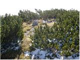
 | Mojstrana - Vrtaški vrh (old path)
Vrtaški Vrh is a panoramic mountain above Vrata Valley. From the grassy peak, surrounded by dwarf pines, there is a nice view toward the neighbor...
3 h 30 min |
 | Gate (Belca) - Mallestiger Mittagskogel (by road)
Ostra peč, known in German as Mallestiger Mittagskogel, is an 1801 m high mountain located on the northern side of the main Karawanks ridge. From...
3 h 25 min |
 | Srednji vrh - Mallestiger Mittagskogel (Via Grajšca)
Ostra peč, known in German as Mallestiger Mittagskogel, is an 1801 m high mountain located on the northern side of the main Karawanks ridge. From...
3 h 10 min |
 | Javorje (Mala Črna) - Komen (via Hlipovec)
At 1684 meters, Komen is the highest peak in the Smrekovec mountain range, which borders between Styria and Carinthia. In good weather, the summi...
4 h 20 min |
 | Javorje (Mala Črna) - Veliki Travnik (Turnovka) (steep path)
Veliki Travnik, also known as Turnovka by the locals, is located on the western edge of the Smrekovec mountain range. From the summit, which has ...
4 h 25 min |
 | Trbiž / Tarviso - Svete Višarje / Monte Lussari (on transport road)
Svete Višarje / Monte Lussari is a pilgrimage site for Slavs, Germans, and Romance peoples. Already in the 16th century, the mountain was called ...
3 h 25 min |
 | Tolminske Ravne - Žabiški Kuk (on mule track)
Žabiški Kuk is located on the southern side ridge of the Lower Bohinj Mountains near the more renowned Vogel and above Planina Razor. From the su...
3 h 45 min |
 | Kneške Ravne - Vrh Planje (above Globoko)
Vrh Planje is a less prominent peak in the ridge of the Lower Bohinj Mountains, which has been increasingly visited lately. Vrh Planje (above Glo...
4 h 30 min |
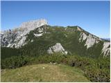
 | Draga - Šentanski vrh (via Ledena trata)
Šentanski vrh, located in the Dobrča range just five minutes from the main peak, offers a nice view of the central Karawanks, the Storžič group, ...
3 h 5 min |
 | Stržišče - Jehlc (Špičasta kupa)
Different maps list various names for Jehlc, which also vary in elevation. Locals call the peak Jehlc (1625 m), while newer maps show Jehelc and ...
3 h 30 min |
 | Gate (Belca) - Maloško poldne / Mallestiger Mittagskogel (by road)
Maloško poldne, or Mallestiger Mittagskogel in German, is a 1,823-meter-high peak on the border between Slovenia and Austria, precisely between T...
3 h 10 min |
 | Vas na Skali - Čisti vrh
Čisti vrh is a 1875 m high mountain located north of the Špičje ridge, more precisely on a panoramic elevation above the Čez Drt saddle. From the...
3 h 30 min |
 | Petrovo Brdo - Rušni vrh
Rušni vrh is a 1,786-meter-high peak located east of Črna Prst. From the summit, which features a border stone from the old Rapallo border, a bea...
4 h 30 min |
 | Kosmačev preval - Lengarjeva glava
Lengarjeva glava is a 1,498 m high peak situated between the Vrata and Kot valleys. From the partly vegetated summit, a nice view opens up on Deb...
3 h 30 min |
 | Kneške Ravne - Grušnica (via Planina na Kalu)
Grušnica is a 1,570-meter-high peak located between Čadrg, the Tolminka valley, and Tolminske Ravne. From the summit, which drops steeply toward ...
4 h 30 min |
 | Jasna - Visoka peč (via Mojčin dom)
Visoka peč is a 1,749-meter-high mountain located southwest of Ciprnik. From its summit, which steeply descends towards Planica and features a sm...
3 h 30 min |
| Kranjska Gora - Visoka peč (via Bedančev dom)
Visoka peč is a 1,749-meter-high mountain located southwest of Ciprnik. From its summit, which steeply descends towards Planica and features a sm...
3 h 25 min |
 | Dom v Lepeni - Velika Montura
Velika Montura is a panoramic peak located between Velika Baba, Lanževica, Bogatin, and Veliki Šmohor. Just below the summit are old Italian bord...
3 h 55 min |
 | Rebrca / Rechberg - Stara gora / Altberg (via Rokov vrh)
Stara gora is a 1,552-meter-high peak located northeast of Ojstrca, the highest peak of Obir. On the summit stand a wooden cross and a bench, wit...
3 h 10 min |
 | Concentration camp - Hajnžev Praprotnik / Zeller Prapotnik
Hajnžev Praprotnik is a 1,727-metre peak on the Austrian side of the Karawanks, more precisely between Košutica and the settlement of Sele-Zvrhnj...
3 h 15 min |
| Vranček - Hajnžev Praprotnik / Zeller Prapotnik
Hajnžev Praprotnik is a 1,727-metre peak on the Austrian side of the Karawanks, more precisely between Košutica and the settlement of Sele-Zvrhnj...
3 h 20 min |
| Sele-Zvrhnji Kot (Male) / Zell-Oberwinkel (Male) - Hajnžev Praprotnik / Zeller Prapotnik
Hajnžev Praprotnik is a 1,727-metre peak on the Austrian side of the Karawanks, more precisely between Košutica and the settlement of Sele-Zvrhnj...
3 h 55 min |
 | Ombrico - Monte Gosadon
Monte Gosadon is a somewhat less-visited peak in the Naborjet Mountains group. The surroundings of the peak also feature quite a few remains from...
3 h 40 min |
 | Hirschegg - Peterer Riegel (by grazing fence)
Peterer Riegel is a panoramic peak above the Peterer Sattel saddle. From the summit, where a cross stands and a bench sits below it, a beautiful ...
4 h 5 min |
 | Hirschegg - Peterer Riegel (via Peterer Alm)
Peterer Riegel is a panoramic peak above the Peterer Sattel saddle. From the summit, where a cross stands and a bench sits below it, a beautiful ...
4 h 10 min |
 | St. Corona am Wechsel - Schöberlriegel
Schöberlriegel is a 1,704-meter-high peak situated north of Hochwechsel. From the summit, where a large cairn stands, a beautiful view opens up o...
4 h 20 min |
 | parking lot Hoyer (Neuhofgraben) - Speikkogel (Gleinalpe) (via Kreuzsattel)
Speikkogel lies northwest of Graz and, at 1988 m, is the second highest peak of the Gleinalpe.The European path E6 and the Austrian Central Alpin...
4 h 10 min |
 | parking lot Hoyer (Neuhofgraben) - Lenzmoarkogel (Gleinalpe) (via Kreuzsattel)
Lenzmoarkogel is located northwest of Gradec and, at 1991 meters above sea level, is the highest peak of the Gleinalpe (Glinska planina).The thre...
4 h 25 min |
 | Aflenz Kurort (Freibad Aflenz) - Hochstein (at Mitteralm) (via Windgrube)
Hochstein is a scenic summit with a cross and summit register box in the Hochschwab mountain group, between Windgrube peak and the Mitteralm plat...
3 h 35 min |
| Aflenz Kurort (Bürgergraben) - Hochstein (at Mitteralm) (via Windgrube)
Hochstein is a scenic summit with a cross and summit register box in the Hochschwab mountain group, between Windgrube peak and the Mitteralm plat...
3 h 35 min |
 | parking lot Hoyer (Neuhofgraben) - Lärchkogel (Gleinalpe) (via Kreuzsattel)
Lärchkogel is a 1,894-meter peak in the Gleinalpe massif with a cross and a small shelter beside it. From the summit, there are fine views of Spe...
3 h 15 min |