 | Volovljek - Kranjska reber (on unmarked path)
Kranjska reber, also known as Vrh Kašne planine (1435 m), is a mountain of volcanic origin. From the summit, which has a registration box with a ...
1 h 15 min |
 | Kosmačev preval - Črna gora
The summit is located between the Kot and Vrata valleys. A bivouac with two sleeping places stands on the summit. The view is beautiful towards K...
1 h 15 min |
 | Planina Vetrh - Bela peč (via Koča pr. Zdravc)
The mountain, known mainly among climbers, is located north of Storžič on the slopes of Konjščica. From the summit there is a beautiful view of t...
1 h 15 min |
 | Kajfežev rob - Kamniški vrh
Kamniški vrh is a 1259-metre-high mountain located north of Kamnik, more precisely between Stahovica and the Korošica valley. From the summit, wh...
1 h 15 min |
 | Za Malim vrhom - Krevl
Krevl is a 1515-meter-high peak situated south of the Kobla ski area, more precisely between the Kobla peak and Kravja Črna gora. From the summit...
1 h |
 | Planina pod Golico - Španov vrh
Španov vrh is a 1334-meter-high mountain in the Karavanke that rises between Javorniški Rovt and Planina pod Golico. From the scenic summit, acce...
1 h 15 min |
 | Planina Lom - Kobilja glava
Kobilja glava is a 1,475-meter-high peak located east of Tolmin. From the summit, where a cross stands, there is a beautiful view of Krn, the ran...
1 h 15 min |
 | Makekova Kočna - Skubrov vrh
Skubrov vrh is a 1276 m high mountain rising steeply above the Ravenska Kočna valley. The forested summit offers no views....
1 h 10 min |
 | Makekova Kočna - Turni
Turni is a lesser-known peak above the eponymous cliffs that rise above Planšarsko jezero. From the summit, which features a logbook box, a beaut...
1 h |
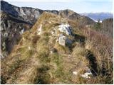
 | Poden / Bodental - Požgani rob
Požgani rob is a 1,513-meter-high mountain north of Rjavca. The summit is surrounded by forest, so there is no good view from it, but a nice pano...
1 h 10 min |
 | Matevljek - Petelinjek
Petelinjek is a 1212 m high peak located in the Racna gora range. From the summit, where there is a small metal chair, a cairn, and an old ladder...
1 h 15 min |
 | Pri Žagi (Javorniški Rovt) - Velika Boncla
Velika Boncla is a 1,241-meter-high, partly rocky peak located between Javorniški Rovt and the Stamare mountain pasture in the Karawanks. From th...
1 h |
 | Rotek - Erbelc
Erbelc is a 1,308-meter-high peak that rises steeply above Zgornja Sorica. From the summit, which has a summit logbook, there is a fine view of t...
1 h 15 min |
| Spodnje Danje - Erbelc
Erbelc is a 1,308-meter-high peak that rises steeply above Zgornja Sorica. From the summit, which has a summit logbook, there is a fine view of t...
1 h 15 min |
 | Rotek - Tonderškofel
Tonderškofel is a 1,326-meter-high peak located between Soriška peč and Erbelc. From the partly overgrown summit, which has no marked trail leadi...
1 h 15 min |
| Spodnje Danje - Tonderškofel
Tonderškofel is a 1,326-meter-high peak located between Soriška peč and Erbelc. From the partly overgrown summit, which has no marked trail leadi...
1 h 15 min |
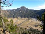
 | Planina pod Golico - Na pečeh at Črni Vrh
Na pečeh is a lesser-known panoramic peak at 1,318 meters above sea level, rising east above the village of Planina pod Golico. Before the Španov...
1 h 5 min |
 | Topla (Končnik) - Šoparjev vrh
Šoparjev vrh is a 1,524-meter-high mountain located between Olševa and Peca, more precisely on the ridge separating the Koprivna Valley from the ...
1 h 15 min |
| Koprivna (Kumer) - Šoparjev vrh
Šoparjev vrh is a 1,524-meter-high mountain located between Olševa and Peca, more precisely on the ridge separating the Koprivna Valley from the ...
1 h 10 min |
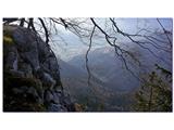
 | Erjavčev rovt - Bela peč (above Dovje)
Bela peč is a lesser-known peak located above the marked trail from Dovje to Dovška Baba. From the summit, there is a beautiful view to the south...
1 h 15 min |
 | Dovje - Blažčeva skala (western path)
Blažčeva skala is a 1,091-meter-high hill located northeast of Mojstrana and Dovje. The summit, known more among climbers than hikers due to the ...
1 h |
 | Dražgoše (Na Pečeh) - Britmanca
Britmanca is a 1,231-meter-high peak on the edge of the Jelovica plateau. Slightly south and lower from the summit along a well-worn path lies a ...
1 h 10 min |
| Dražgoše (Jelenšče) - Britmanca (gentle path)
Britmanca is a 1,231-meter-high peak on the edge of the Jelovica plateau. Slightly south and lower from the summit along a well-worn path lies a ...
1 h 15 min |