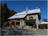
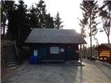
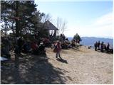
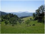
 | Vrčice - Dom na Mirni gori (by road)
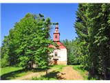
The Dom na Mirni Gori mountain hut is located just a few dozen metres below the summit of Mirna Gora. From the hut or from the nearby viewpoint t...
2 h 15 min |
 | Vrčice - Dom na Mirni gori (via Škrilj)
The Dom na Mirni Gori mountain hut is located just a few dozen metres below the summit of Mirna Gora. From the hut or from the nearby viewpoint t...
2 h |
| Vrčice - Dom na Mirni gori (via Planina)
The Dom na Mirni Gori mountain hut is located just a few dozen metres below the summit of Mirna Gora. From the hut or from the nearby viewpoint t...
2 h |
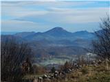
 | Zgornje Poljčane - Boč (via Baba)
Boč is among the last peaks in the Karawanks before they transition over Donačka gora and Macelj into the Pannonian Plain. Boč has two approximat...
1 h 55 min |
 | Hotavlje - Koča na Ermanovcu (via Slajka)
The mountain hut is situated northwest of Ermanovec below the summit of Štor. From the hut or its nearby surroundings, there is a nice view towar...
2 h 45 min |
| Hotavlje - Koča na Ermanovcu (by road)
The mountain hut is situated northwest of Ermanovec below the summit of Štor. From the hut or its nearby surroundings, there is a nice view towar...
2 h 10 min |
 | Žiri - Koča na Vrhu Svetih Treh Kraljev
The mountain hut is located just a few minutes below the 884-meter-high peak Vrh Svetih Treh Kraljev. It lies in the Rovtarsko hribovje and is ac...
2 h 20 min |
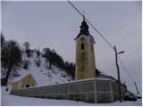
 | Moravče - Dom na Slivni (via Pivkelj)
The Dom na Zgornji Slivni mountain hut is located west of GEOSS on the eastern slopes of Pivkelj peak. Near the closed hut is the church of St. N...
2 h 50 min |
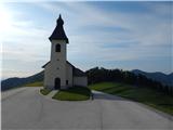
 | Grčarevec - Sveta Marija on Planinska gora (on path Jakobova pot and past hunting cotage)
Planinska gora rises above the Planinsko polje near Planina. Below Grmada (873 m), the easternmost peak of Planinska gora, is the church of the H...
2 h 10 min |
 | Grčarevec - Sveta Marija on Planinska gora (Jakobova pot)
Planinska gora rises above the Planinsko polje near Planina. Below Grmada (873 m), the easternmost peak of Planinska gora, is the church of the H...
2 h |
 | Grčarevec - Hunting cottage on Planinska gora (Jakobova pot)
The hunting cottage on Planinska gora is located between Grmada (873 m) and Petričev hrib (937 m). A macadam road from Lohača (a village near Pla...
2 h |
 | Vransko - Dom na Čreti
The Dom na Čreti mountain hut is located north of Vransko on the central part of the Dobroveljska planota plateau. Near the hut are two small chu...
1 h 45 min |
 | Kokarje (ŠRC Laze) - Dom na Čreti (via Dom na Farbanci)
The Dom na Čreti mountain hut is located north of Vransko on the central part of the Dobroveljska planota plateau. Near the hut are two small chu...
2 h |
 | Divje jezero - Koča na Hleviški planini (via Prižnica)
The Koča na Hleviški planini mountain hut is located just below the 908 m high peak of Hleviška planina. From the hut, a control point on the Slo...
2 h 20 min |
 | Idrija - Koča na Hleviški planini (via Kodrov rovt)
The Koča na Hleviški planini mountain hut is located just below the 908 m high peak of Hleviška planina. From the hut, a control point on the Slo...
1 h 50 min |
 | Lesično - Koča na Bohorju
The mountain hut, accessible by car, is situated on the slopes of Bohor. From the hut, there is a limited view mainly to the south and west, obst...
3 h |
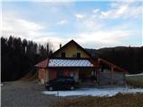
 | Pirman - Planinski dom na Kureščku
The Planinski dom na Kureščku mountain hut is located just a few dozen meters below the summit of Kurešček. From the hut or the nearby meadow, a ...
1 h 45 min |
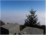
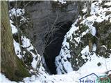 | Kočevje - Ledena jama on Stojna (Kalan way)
The Ledena jama cave is located south of the Koča pri Jelenovem studencu cottage, in the midst of the extensive forests of Stojna. Over 100 m dee...
1 h 45 min |
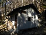
 | Jelovec - Koča na Žavcarjevem vrhu
The mountain hut is located just a few dozen meters below Žavcarjev vrh, on the slopes of Kozjak. From the hut, which is mostly surrounded by for...
2 h 15 min |
 | Kozjak nad Pesnico - Planinski dom Kozjak
The mountain hut is located just a few meters below Tojzlov vrh on the eastern slopes of Kozjak. Due to the surrounding forest, there is no nice ...
2 h |
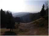
 | Vitovlje - Kopitnik (via Sekulak)
Kopitnik, known as a paragliding take-off point, is situated above the village of Vitovlje above the Vipava Valley. Near the take-off point there...
2 h 30 min |
 | Vrtovin - Bivak Črna peč
Bivak Črna peč is a closed-type bivouac owned by the Čaven hunting family. From the bivouac, located below the steep slopes of Črna peč, there is...
1 h 45 min |
 | Železniki - Prtovč (via Draoboslovica)
Prtovč is a small hill village located west of Železniki. On a panoramic grassy ridge right next to the village stands the Church of Mary Help of...
1 h 45 min |
 | Stranice - Hunting cottage Štepih
The Štepih Hunting Cottage is located in the middle of the forests of Konjiška gora, more precisely below the 1012 m high Stolpnik. The cottage, ...
1 h 50 min |
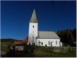 | Dravograd - Church of St. John the Baptist on Ojstrica
The Church of St. John the Baptist on Ojstrica is located on the edge of panoramic pastures where highland cattle usually graze. From the church ...
1 h 45 min |
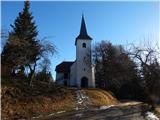
 | Preval - Sveta Katarina (Topol)
The Church of St. Catherine is a parish church located in the village of Topol above Medvode. From the church or its immediate surroundings, a be...
1 h 45 min |
 | Preska - Sveta Katarina (Topol) (via Turnice)
The Church of St. Catherine is a parish church located in the village of Topol above Medvode. From the church or its immediate surroundings, a be...
2 h 20 min |
| Preska - Sveta Katarina (Topol) (via Jeterbenk)
The Church of St. Catherine is a parish church located in the village of Topol above Medvode. From the church or its immediate surroundings, a be...
2 h 35 min |
 | Kokarje (ŠRC Laze) - Holy Mother of God on Čreta (via Dom na Farbanci)
The Church of the Holy Mother of God on Čreta is located west of the lesser-known forested peak Vrhe. From the church or its immediate surroundin...
2 h |
 | Zabočevo - Rakitna
Rakitna is a popular excursion spot for residents of the Ljubljana Marshes and surrounding areas. The village center features the Church of the H...
1 h 45 min |
 | Lavamünd - St. Lorenzen (Lorenzenberg)
The Church of St. Lorenzen is located on the edge of the village Lorenzenberg, east of Labot/Lavamünd. From the church or its immediate surroundi...
2 h |
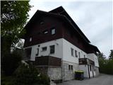
 | Loke - Planinski dom Vrhe
The Planinski dom Vrhe mountain hut is situated on the southeast slopes of Kisovec peak, from where a nice view opens up to the nearby Javor. Nea...
1 h 50 min |
 | Trbovlje - Planinski dom Vrhe
The Planinski dom Vrhe mountain hut is situated on the southeast slopes of Kisovec peak, from where a nice view opens up to the nearby Javor. Nea...
2 h 30 min |
 | Bistriški jarek (Verdinek) - Sveti Primož above Muta
Sveti Primož above Muta is a dispersed settlement rising north of Muta. The Church of St. Primož and Felicijan, located on the ridge between Prim...
3 h |
| Radlje ob Dravi - Sveti Primož above Muta
Sveti Primož above Muta is a dispersed settlement rising north of Muta. The Church of St. Primož and Felicijan, located on the ridge between Prim...
2 h 30 min |
| Dolina Radeljskega potoka (Razdevšek) - Sveti Primož above Muta
Sveti Primož above Muta is a dispersed settlement rising north of Muta. The Church of St. Primož and Felicijan, located on the ridge between Prim...
2 h 20 min |
 | Radlje ob Dravi - Zavetišče Onuk - Glavar
The Zavetišče Onuk - Glavar shelter is located below Bricnik peak in the settlement of Sveti Primož above Muta. It offers the KPP (Koroška Planin...
2 h 15 min |
| Dolina Radeljskega potoka (Razdevšek) - Zavetišče Onuk - Glavar
The Zavetišče Onuk - Glavar shelter is located below Bricnik peak in the settlement of Sveti Primož above Muta. It offers the KPP (Koroška Planin...
2 h 5 min |
 | Radlje ob Dravi - Sveti Urban (Radelca) (via Župank)
The Church of St. Urban on Radelca stands on the southern slopes of the border ridge Radelj. Built in the mid-17th century amid nearby forest, it...
3 h 15 min |
 | Brezno - Sveti Urban (Radelca) (along Remšniški potok)
The Church of St. Urban on Radelca stands on the southern slopes of the border ridge Radelj. Built in the mid-17th century amid nearby forest, it...
2 h 30 min |
 | Rein - Mühlbacher Hütte (Hunting path / Jägersteig)
The Mühlbacher Hütte mountain hut stands at 996 m above sea level above the Mühlbacher Graben near Rein and is a popular destination for cyclists...
2 h |
 | Rein - Mühlbacher Hütte (via Hochstein)
The Mühlbacher Hütte mountain hut stands at 996 m above sea level above the Mühlbacher Graben near Rein and is a popular destination for cyclists...
2 h 15 min |
 | Lovrenc na Pohorju - Sveti Ignacij (Rdeči Breg) (via Povh and Brabar)
The Church of St. Ignacij is situated on the periphery of the settlement Rdeči Breg, which rises northwest of Lovrenc na Pohorju and only a littl...
2 h 25 min |
 | Lovrenc na Pohorju - Sveti Ignacij (Rdeči Breg)
The Church of St. Ignacij is situated on the periphery of the settlement Rdeči Breg, which rises northwest of Lovrenc na Pohorju and only a littl...
2 h 5 min |
| Puščava - Sveti Ignacij (Rdeči Breg)
The Church of St. Ignacij is situated on the periphery of the settlement Rdeči Breg, which rises northwest of Lovrenc na Pohorju and only a littl...
2 h 50 min |
| Lovrenc na Pohorju - Sveti Ignacij (Rdeči Breg) (via Kapus)
The Church of St. Ignacij is situated on the periphery of the settlement Rdeči Breg, which rises northwest of Lovrenc na Pohorju and only a littl...
2 h 35 min |
| HE Ožbalt - Sveti Ignacij (Rdeči Breg)
The Church of St. Ignacij is situated on the periphery of the settlement Rdeči Breg, which rises northwest of Lovrenc na Pohorju and only a littl...
2 h 45 min |
 | Podvelka - Sveti Ignacij (Rdeči Breg)
The Church of St. Ignacij is situated on the periphery of the settlement Rdeči Breg, which rises northwest of Lovrenc na Pohorju and only a littl...
1 h 55 min |
 | Zgornja Bistrica (Center Vintgar) - Šetorov mlin (via Bistriški vintgar)
Šetorov Mill is situated on Pohorje at the Rihtarjev Potok stream, only a few minutes away from the Šmartno na PohorjuBojtina road....
2 h 45 min |
 | Zgornja Bistrica (Center Vintgar) - Majalova Chapel (via Bistriški vintgar)
Majalova Chapel is located south of the Majal homestead, from where a nice view opens up onto the nearby surroundings....
2 h 45 min |
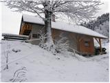
 | Puščava - Hunting cottage Klančnik
The Hunting Cottage Klančnik is located just below the Klančnik peak on the panoramic grassy slopes of Rdeči Breg....
2 h 20 min |
| Lovrenc na Pohorju - Hunting cottage Klančnik (via Kapus)
The Hunting Cottage Klančnik is located just below the Klančnik peak on the panoramic grassy slopes of Rdeči Breg....
2 h 5 min |
 | Lovrenc na Pohorju - Hunting cottage Klančnik (via Povh, Brabar and Hudej)
The Hunting Cottage Klančnik is located just below the Klančnik peak on the panoramic grassy slopes of Rdeči Breg....
2 h 20 min |
| Janževski Vrh (Uran) - Hunting cottage Klančnik (via Sveti Ignacij)
The Hunting Cottage Klančnik is located just below the Klančnik peak on the panoramic grassy slopes of Rdeči Breg....
1 h 55 min |
| HE Ožbalt - Hunting cottage Klančnik
The Hunting Cottage Klančnik is located just below the Klančnik peak on the panoramic grassy slopes of Rdeči Breg....
2 h 15 min |
| Podvelka - Hunting cottage Klančnik (via Sveti Ignacij)
The Hunting Cottage Klančnik is located just below the Klančnik peak on the panoramic grassy slopes of Rdeči Breg....
2 h 25 min |
 | Fram - Church of the Holy Cross (Planica)
The succursal Church of the Holy Cross in Planica is located on Slivniško Pohorje, above the left bank of the Brunik Stream. Next to the church i...
2 h |
 | Zgornja Bistrica (Center Vintgar) - Marolt fir tree (Bistriški vintgar)
The Marolt fir tree is slowly rotting today. Until 2010, when it collapsed in a fire, it was the thickest fir tree in Europe, with a circumferenc...
1 h 45 min |
 | Stubenbergsee - Mariabrunn (via Kulmkögerl)
Mariabrunn is a small chapel located on the western slopes of Kulm peak....
1 h 53 min |
 | Zgornja Bistrica (Center Vintgar) - Ponds Devin in Ošelj (via Bistriški vintgar)
The Devin Ponds in Ošelj are located on the outskirts of the settlement Ošelj in the southeastern part of Pohorje....
2 h 15 min |
 | Zgornja Bistrica (Center Vintgar) - Pond west of Ošelj (via Bistriški vintgar)
The pond west of Ošelj lies among the Pohorje forests, near the settlements of Smrečno and Ošelj....
2 h 5 min |
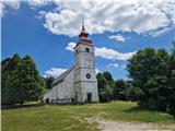
 | Ruše - Sveta Marija (Smolnik)
The Church of Holy Mary is situated at the edge of the forest and on the periphery of the hamlet Hlebovo, near the settlement Smolnik....
2 h 5 min |
| Smolnik (Marotov most) - Sveta Marija (Smolnik) (through valley of Lobnica)
The Church of Holy Mary is situated at the edge of the forest and on the periphery of the hamlet Hlebovo, near the settlement Smolnik....
2 h 5 min |
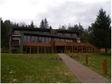
 | Pivola (Reka) - Hotel Tisa (Poštarski dom) (via Petkovo sedlo)
Hotel Tisa, the former Poštarski dom, is situated at the edge of the Hočko Pohorje forests. The hotel, known for its original Pohorje omelette, o...
1 h 45 min |
| Fram - Hotel Tisa (Poštarski dom) (via Petkovo sedlo)
Hotel Tisa, the former Poštarski dom, is situated at the edge of the Hočko Pohorje forests. The hotel, known for its original Pohorje omelette, o...
2 h 30 min |
| Slivnica pri Mariboru - Hotel Tisa (Poštarski dom)
Hotel Tisa, the former Poštarski dom, is situated at the edge of the Hočko Pohorje forests. The hotel, known for its original Pohorje omelette, o...
2 h 30 min |
 | Zgornja Polskava - Sveti Martin (Šmartno na Pohorju) (through Polskavski vintgar)
The Church of St. Martin is situated on the edge of the built-up area of Šmartno na Pohorju. From the church or its immediate surroundings, a bea...
2 h 45 min |
| Zgornja Polskava - Sveti Martin (Šmartno na Pohorju) (via Kočna pri Polskavi)
The Church of St. Martin is situated on the edge of the built-up area of Šmartno na Pohorju. From the church or its immediate surroundings, a bea...
2 h 15 min |
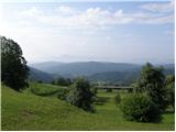
 | Grčarevec - Viewpoint below Srnjak above Logatec
The viewpoint below Srnjak above Logatec was established a few years ago and has become a popular excursion spot for Logatec residents and other ...
2 h |
 | Podgorje ob Sevnični (Kurja vas) - Darinkino zavetišče on Ivce
Darinkino zavetišče on Ivcah is located along the marked path Podgorje ob Sevnični Ješivec, south of the Ivc peak....
1 h 45 min |