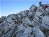
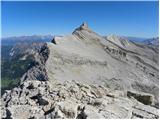
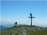
 | Planina Blato - Kanjavec (Za Kopico)
Kanjavec is a 2,569-meter-high mountain located between Dolič and Hribarice. From the summit, which has a logbook box and a stamp, a beautiful vi...
5 h 35 min |
 | The Krma Valley - Triglavski dom na Kredarici
The Triglav Hut at Kredarica is the highest-lying serviced Slovenian mountain hut. It is open all year round but outside the season only on an em...
5 h |
 | Dolina Krma - Begunjski vrh
Begunjski Vrh is a 2,461 m high mountain located in the heart of the highest peaks of the Julian Alps. From the summit, which has a registration ...
5 h 45 min |
 | Ljubelj - Hochstuhl/Stol (lower path)
Stol is, at 2,236 m, the highest peak in the Karawanks. From the summit, which has a registration box and stamp, a beautiful view opens onto the ...
4 h 50 min |
 | Tinčkova koča - Hochstuhl/Stol (via Smokuška planina)
Stol is, at 2,236 m, the highest peak in the Karawanks. From the summit, which has a registration box and stamp, a beautiful view opens onto the ...
4 h 15 min |
 | Dom Trilobit - Hochstuhl/Stol (via Rida (Medji dol))
Stol is, at 2,236 m, the highest peak in the Karawanks. From the summit, which has a registration box and stamp, a beautiful view opens onto the ...
4 h 30 min |
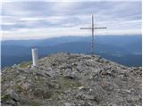
 | Kriška planina - Kalški greben (via planina Koren)
Kalški greben is a 2224 m high peak and the highest point of the ridge bearing the same name. From the summit, where there is a summit register a...
3 h 45 min |
| Planina Jezerca - Kalški greben (via planina Koren)
Kalški greben is a 2224 m high peak and the highest point of the ridge bearing the same name. From the summit, where there is a summit register a...
4 h |
| Markova raven - Kalški greben (on marked path)
Kalški greben is a 2224 m high peak and the highest point of the ridge bearing the same name. From the summit, where there is a summit register a...
4 h 30 min |
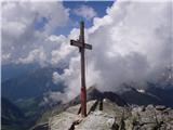
 | The Krma Valley - Visoka Vrbanova špica
Visoka Vrbanova špica is located at the far southwestern end of the ridge rising above the Kot and Vrata valleys, and higher up between the Kot a...
5 h 35 min |
 | Schwarzkogelhütte - Fuchskogel
Fuchskogel is a peak south of Zirbitzkogel in the Seetaler Alpen mountain group. The summit is broad and mostly covered in grass. More precisely,...
6 h 40 min |
 | Weissensee - Latschur (via Almspitz)
Latschur (2,236 m) is the highest peak in the eponymous mountain group. From the summit, which features a cross and a summit logbook box, there i...
4 h 15 min |
 | Weissensee - Almspitz (via Techendorfer Alm)
Almspitz (2,180 m) is a peak in the Latschur group. From its grassy summit, there are beautiful views of the Gailtal Alps, Carnic Alps, Julian Al...
4 h |
 | Weissensee - Eckwand (via Karalm)
Eckwand (2,221 m) is a peak in the Latschur group. From its grassy summit, which features a cross, there are beautiful views of the Gailtal Alps,...
5 h |
 | Weissensee - Hochstaff (via Karalm)
Hochstaff (2,217 m) is a peak in the Latschur group. From its grassy summit, which features a cross, there are beautiful views of the nearby Gold...
5 h |
 | Goldberg - Jaukenstöckl
Jaukenstöckl is a 2209 m high peak on the western side of the panoramic Jauken ridge. From the summit, where a statue of the Virgin Mary stands, ...
3 h 45 min |
 | Goldberg - Jaukenhöhe
Jaukenhöhe is a little-visited peak in the Jauken ridge. It lies west of Torkofel, the highest point in the ridge at 2276 m. The grassy, steep su...
3 h 45 min |
 | Dösner Alm - Säuleck
Säuleck is a 3,086-meter peak in the High Tauern. The summit features a cross and summit register box, providing nice views of nearby peaks such ...
5 h 30 min |
 | Prebersee - Preber (via Mühlbachtörl)
Preber is a 2740 m high peak located in the heart of the Schladminger Tauern mountain group. The summit, where a cross stands, is a very popular ...
3 h 45 min |
 | Piano Fiscalino / Fischleinboden - Croda Fiscalina di Mezzo / Oberbachernspitze
Croda Fiscalina di Mezzo, or in German Oberbachernspitze, is a 2675-meter-high mountain located in the heart of the Dolomiti di Sesto / Sextner D...
4 h |
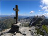 | Erschbaum - Pfannspitze / Cima Vanscuro
Pfannspitze / Cima Vanscuro is a 2,678-meter mountain in the western Carnic Alps. From its cross-topped summit, there are excellent views of the ...
4 h 45 min |
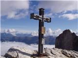
 | Rifugio Pederü - L'Ciaval / Kreuzkofel (path 12)
L'Ciaval / Kreuzkofel is a 2,907-meter-high mountain in the Lavarella group. The mountain and the entire ridge it's located in are recognizable b...
4 h 45 min |
| Rifugio Pederü - L'Ciaval / Kreuzkofel (path 7)
L'Ciaval / Kreuzkofel is a 2,907-meter-high mountain in the Lavarella group. The mountain and the entire ridge it's located in are recognizable b...
4 h 50 min |
 | Stary Smokovec - Slavkovsky štit
Slavkovsky štit is the fourth-highest peak in the High Tatras, standing at 2,452 meters. It is located south of the Velká Studená dolina valley a...
4 h 10 min |
 | Sportgastein - Greilkopf (via Hagener Hütte)
Greilkopf is a 2,581 m high mountain in the Ankogel group of the Hohe Tauern in Austria above the town of Mallnitz. It is a popular winter destin...
3 h 45 min |
 | Mallnitz - Greilkopf
Greilkopf is a 2,581 m high mountain in the Ankogel group of the Hohe Tauern in Austria above the town of Mallnitz. It is a popular winter destin...
5 h 30 min |
 | Dolina Krma - Kredarica
Kredarica is a 2,541-meter-high panoramic peak located between Triglav and Rž. From the summit, a nice view opens up towards Triglav and the surr...
5 h 5 min |
 | Mallnitz - Feldseekopf (via Feldseescharte)
Feldseekopf, at 2,864 m, is as high as Triglav. The mountain is located in the Goldberg group of the Hohe Tauern in Austria and receives far fewe...
6 h 10 min |
 | Parking below Jamnigalm - Feldseekopf (via Feldseecharte)
Feldseekopf, at 2,864 m, is as high as Triglav. The mountain is located in the Goldberg group of the Hohe Tauern in Austria and receives far fewe...
3 h 50 min |
 | Turrach - Eisenhut
Eisenhut, at 2,441 meters, is the highest peak in the Gurktal Alps, which stretch across the basin of the Krka/Gurk River and descend to the nort...
4 h 30 min |
| Turrach - Eisenhut (via Straßburger Spitz)
Eisenhut, at 2,441 meters, is the highest peak in the Gurktal Alps, which stretch across the basin of the Krka/Gurk River and descend to the nort...
5 h |
 | Turrach - Straßburger Spitz
Straßburger Spitz is a 2,404-meter-high peak located between the summits of Eisenhut (2,441 m) and Wintertalernock (2,394 m). From the top, where...
4 h |
 | Turrach - Wintertalernock
Wintertalernock is a 2,394-meter-high peak located southeast of the highest summit of the Gurktal Alps, Eisenhut. From the top, where a cross sta...
4 h 15 min |
 | Gozdec - Vrh Osojnic
Vrh Osojnic is a 2,371-meter-high peak located between the Dom Petra Skalarja hut on Kanin and Hudi Vršič. From the summit, where a cairn stands,...
4 h 40 min |
 | Parking Sulzenauhütte - Gamsspitzl (via Sulzenauhütte and Seescharte)
Gamsspitzl is a less prominent three-thousander located on a long ridge stretching north from the summit plateaus of Wilder Freiger. Due to its e...
5 h 15 min |
 | Nida - Timios Stavros / Psiloritis (Kreta)
Timios Stavros is Crete's highest mountain at 2,456 meters and also the highest among the Greek islands. Due to its topographic prominence, it is...
4 h 15 min |
 | Seetal - Hochschwab
Hochschwab, at 2,277 meters, is the highest peak of its namesake mountain group in the Northern Limestone Alps. From the summit, where a cross st...
5 h |
| Seetal - Hochschwab (past Schiestelhaus)
Hochschwab, at 2,277 meters, is the highest peak of its namesake mountain group in the Northern Limestone Alps. From the summit, where a cross st...
5 h 5 min |
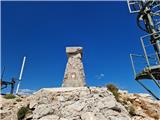 | Masna Luka - Pločno
Pločno is the highest peak of the Čvrsnica range and the fourth highest peak in Bosnia and Herzegovina. At its highest point is a geodetic pillar...
4 h 30 min |