 | Lohača - Petričev hrib
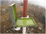
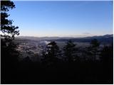
Petričev hrib is a peak north of Postojna and west of Planina. From the summit, which has a logbook box, there is a nice view of the Notranjska h...
45 min |
 | Dobrič (Vedet) - Gora Oljka (by road)
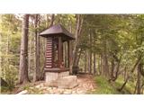
Gora Oljka is a hill located east of Šmartno ob Paki. On the summit stands the Church of the Holy Cross, built in the mid-18th century. Just a fe...
50 min |
 | Pogorelec - Sedlata gorica (Pogorelec)
Sedlata gorica is a peak above the village of Podturn pri Dolenjskih Toplicah. It used to be forested, but today a clearing on the summit is used...
45 min |
 | Lučine - Sivka
Sivka is a grassy peak at the far western end of Polhograjsko hribovje. On clear days, it offers breathtaking views from Snežnik across Javorniki...
50 min |
 | Tone Čufar square (Jesenice) - Kalvarija above Jesenice (steep path)
Kalvarija is a popular point or peak above the town of Jesenice, known either as a sort of short "pilgrimage" path for the faithful or as a desti...
35 min |
 | Koroška Bela - Malnež
Malnež is an 846-meter-high panoramic peak in the southern Karawanks, situated on the eastern side of the small valley where the village of Koroš...
40 min |
 | Podblica - Sveti Primož in Felicijan (Jamnik)
The Church of St. Primož and Felicijan at Jamnik is located on a scenic grassy ridge rising between Kropa and Podblica. From the church or its ne...
50 min |
 | Zgornja Besnica (Nova vas) - Rovnik (west path)
Rovnik is a 707-meter-high peak located west of Zgornja Besnica. The summit features two benches, a wish bell, and a logbook box, but offers no v...
40 min |
 | Zgornja Besnica (Nova vas) - Rovnik (east path)
Rovnik is a 707-meter-high peak located west of Zgornja Besnica. The summit features two benches, a wish bell, and a logbook box, but offers no v...
45 min |
 | Parje - Primož
Primož is a 718-meter-high peak located south to southeast of Pivka. Due to its ideal location overlooking the entire Pivka Basin, the Italians b...
40 min |
 | Grad Hošperk - Stari grad
Stari grad is a 703-meter-high peak between Planina and Unec. From the summit, home to transmitters and obscured by forest and bushes, views are ...
40 min |
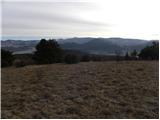 | Šembije - Vrh
Vrh is a 777-meter-high peak north of Šembije and southwest of Knežak. From the grassy summit, dotted with scattered bushes, fine views extend to...
45 min |
 | Čepovan (Želinc) - Vrh Skopice
Vrh Skopice, also known as Skopica, is a panoramic peak located between the Čepovan Valley, the Idrijca River valley, and the Trebuščica River va...
50 min |
 | Olševek - Apnišče (west path)
Apnišče is a 740 m high mountain between Možjanca and Štefanja gora. It is the highest point of the Šenčur municipality. The forested summit offe...
55 min |
 | Olševek - Apnišče (via Šterna)
Apnišče is a 740 m high mountain between Možjanca and Štefanja gora. It is the highest point of the Šenčur municipality. The forested summit offe...
55 min |
 | Podhom - Hom at Bled
Hom is an 834-meter-high hill rising north above the villages of Zasip and Podhom near Bled, or south of the village Blejska Dobrava near Jesenic...
40 min |
 | Kočna - Vrše (by ski slope)
The 850-meter-high hill Vrše, over which the Triglav National Park border runs, rises southwest above the village of Blejska Dobrava, or east of ...
45 min |
 | Kočna - Vrše (čez senožeti)
The 850-meter-high hill Vrše, over which the Triglav National Park border runs, rises southwest above the village of Blejska Dobrava, or east of ...
50 min |
 | Rodik - Ajdovščina
Ajdovščina is an 804-meter-high peak located above Rodik and Slopami. A metal container stands on the overgrown summit today, and ruins of a form...
40 min |
 | Železniki - Hujska (via Kres)
Hujska is a 706-meter-high peak located above Železniki, more precisely between the Dašnjica and Češnjica streams. At the summit there is a bench...
45 min |
| Železniki - Hujska
Hujska is a 706-meter-high peak located above Železniki, more precisely between the Dašnjica and Češnjica streams. At the summit there is a bench...
40 min |
 | Mežica - Štalekarjev vrh (on ski slope)
Štalekarjev vrh is a hill above the former Mežica ski slope. There is no good view from the summit itself, but nice views open from the grassy ar...
45 min |
 | Lovrenc na Pohorju (cemetery) - Koglerjev vrh
Koglerjev vrh is a 698-meter-high forested peak located southwest of the organic farm Šlaus-Kogler, which lies above the settlement of Lovrenc na...
45 min |
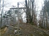
 | Slovenj Gradec - Rahtelov vrh (eastern path)
Rahtelov vrh is located north of Slovenj Gradec, above the left bank of the Mislinja River. On the summit there is a repeater facility and some t...
45 min |
| Slovenj Gradec - Rahtelov vrh (southeastern path)
Rahtelov vrh is located north of Slovenj Gradec, above the left bank of the Mislinja River. On the summit there is a repeater facility and some t...
45 min |
 | Škalnica - Pliševica (Way of the Cross)
Pliševica is a panoramic grassy summit above Škalnica, near the Slovenian border. From the top, marked by a concrete stone with a logbox, beautif...
50 min |