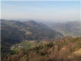
 | Brezje pri Tržiču - Vaško
Vaško is a little-known mountain in the southeastern ridge of Dobrča. From the summit, there is a nice view toward Jelovica and the Julian Alps. ...
55 min |
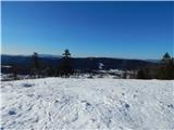
 | Brezje pri Tržiču - Vaško (eastern path)
Vaško is a little-known mountain in the southeastern ridge of Dobrča. From the summit, there is a nice view toward Jelovica and the Julian Alps. ...
1 h 5 min |
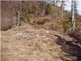
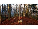
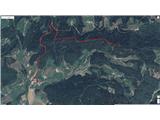
| Water storage Žegnani studenec - Vaško
Vaško is a little-known mountain in the southeastern ridge of Dobrča. From the summit, there is a nice view toward Jelovica and the Julian Alps. ...
1 h 5 min |
 | Lohača - Petričev hrib
Petričev hrib is a peak north of Postojna and west of Planina. From the summit, which has a logbook box, there is a nice view of the Notranjska h...
45 min |
 | Gradec - Osojnica
Osojnica is a forested hill located west of Pivka. The summit features a logbook box, stamp, and bench, but offers no views....
45 min |
 | Pogorelec - Sedlata gorica (Pogorelec)
Sedlata gorica is a peak above the village of Podturn pri Dolenjskih Toplicah. It used to be forested, but today a clearing on the summit is used...
45 min |
 | Tržič - Kamnek (Milanova pot)
Kamnek (Kamnik on maps, also sometimes Kamnjek) is a panoramic peak above Tržič....
1 h 5 min |
 | Tržič (Slap) - Kamnek (via Dobrivc)
Kamnek (Kamnik on maps, also sometimes Kamnjek) is a panoramic peak above Tržič....
1 h |
 | Završnica (Pri žagi) - Smokuški vrh
Smokuški vrh is a panoramic mountain located on the ridge between the Završnica Valley and the Gorenjska plain. From the summit, where there is a...
1 h |
 | Lučine - Sivka
Sivka is a grassy peak at the far western end of Polhograjsko hribovje. On clear days, it offers breathtaking views from Snežnik across Javorniki...
50 min |
 | Prelesje - Sivka
Sivka is a grassy peak at the far western end of Polhograjsko hribovje. On clear days, it offers breathtaking views from Snežnik across Javorniki...
1 h |
 | Planina - Grmada (Planinska gora)
Grmada is an 873-meter-high peak rising west of Planinsko polje. Although the summit is forested, a viewpoint just below it offers a stunning vie...
1 h |
 | Pri Žagi (Javorniški Rovt) - Alničje
Alničje is a 1145 m high ridge-like rise that ascends from the southwest above the Jesenice settlements of Koroška Bela and Javornik, extending n...
1 h |
 | Mesnice - Rotovc (via Županov vrh)
Rotovc is a 964-meter-high peak situated northeast of Rakitna. From the summit, where a wooden bench stands, a beautiful view opens up toward the...
1 h 15 min |
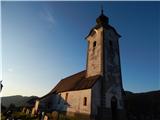
 | Njivica - Sveti Primož in Felicijan (Jamnik)
The Church of St. Primož and Felicijan at Jamnik is located on a scenic grassy ridge rising between Kropa and Podblica. From the church or its ne...
1 h 10 min |
 | Kropa (Slovenska peč) - Sveti Primož in Felicijan (Jamnik)
The Church of St. Primož and Felicijan at Jamnik is located on a scenic grassy ridge rising between Kropa and Podblica. From the church or its ne...
1 h 10 min |
 | Gorenji Novaki (Mrovlje) - Škofje
Škofje is a 973-meter-high peak located above the villages of Čeplez, Planina pri Cerknem, and Podpleče. The summit itself, marked by a small con...
1 h |
 | Čepovan (Želinc) - Vrh Skopice
Vrh Skopice, also known as Skopica, is a panoramic peak located between the Čepovan Valley, the Idrijca River valley, and the Trebuščica River va...
50 min |
 | Brezje nad Kamnikom - Vovar (western way)
A viewless hill in front of the Kamnik mountains. In recent times, due to storms, it is crisscrossed with cart tracks for log extraction.Below th...
1 h |
| Brezje nad Kamnikom - Vovar (northern way)
A viewless hill in front of the Kamnik mountains. In recent times, due to storms, it is crisscrossed with cart tracks for log extraction.Below th...
1 h |
 | Žiri - Javorč
Javorč is a 901-meter-high peak located northeast of Žiri. The summit, featuring a logbox with a logbook, lies at the edge of a larger clearing, ...
1 h 15 min |
 | Rakitna - Županov vrh (via Reber)
Županov vrh is a 999-meter-high peak located southeast of Rakitna. From the grassy summit, where a trigonometric point and a small antenna tower ...
50 min |
 | Col - Špiček (Špečk)
Špiček (locals call it Špečk) is a peak located north to north-east of Col. A cross on the summit honors St. Hubert and commemorates the first an...
55 min |
 | Col - Špiček (Špečk) (via Križna gora)
Špiček (locals call it Špečk) is a peak located north to north-east of Col. A cross on the summit honors St. Hubert and commemorates the first an...
1 h 10 min |
 | Col - Križna gora above Col (via Špiček)
Križna gora is a 957-meter-high peak located north of Col. From the summit, which is forested on the northern side, beautiful views open up to th...
1 h 10 min |
 | Col - Križna gora above Col
Križna gora is a 957-meter-high peak located north of Col. From the summit, which is forested on the northern side, beautiful views open up to th...
55 min |
 | Blejska Dobrava (cemetery) - Hom at Bled (on east slope)
Hom is an 834-meter-high hill rising north above the villages of Zasip and Podhom near Bled, or south of the village Blejska Dobrava near Jesenic...
1 h 5 min |
 | Poljane (Spodnje Gorje) - Boršt (by road)
Boršt is a 931-meter-high vegetated peak located 4 km northwest of Bled, or east of the Mežakla Plateau. Between it and the neighboring peak Hom ...
1 h |
 | Trate (Blejska Dobrava) - Boršt
Boršt is a 931-meter-high vegetated peak located 4 km northwest of Bled, or east of the Mežakla Plateau. Between it and the neighboring peak Hom ...
1 h |
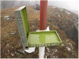
 | Kokra (resting place Kokra-sotočje) - Skutman
Skutman is a lesser-known peak above the left bank of the Kokra River and north of Štefanja Gora. The summit is marked by a metal plaque reading ...
1 h 10 min |
 | Mežica - Andrejev vrh (by cart track)
Andrejev vrh is a forest-covered peak located between Mežica and Leše. On the summit there is a bench and a summit register box with a logbook....
1 h 15 min |
 | Podblica - Sleme (Površnica)
Sleme is a panoramic peak located between Rudno, Dražgoše, and Lajše. From the summit, where transmitters are located, there is a nice view of th...
1 h 10 min |
 | Škalske Cirkovce - Smodivnik
Smodivnik is a less-visited hill that rises on one side above the Huda luknja basin near Dolič and on the other above the Velenje Basin.The summi...
45 min |
 | Senično - Planica (Paragliding site Gozd) (gentle path)
Planica is a 926-meter peak located above the village of Gozd. From the summit, where the JPK Kriška gora cottage stands, a nice view opens up ov...
1 h 15 min |
| Senično - Planica (Paragliding site Gozd) (steep path)
Planica is a 926-meter peak located above the village of Gozd. From the summit, where the JPK Kriška gora cottage stands, a nice view opens up ov...
1 h 10 min |
 | Šenturška Gora - Prgozdnik (Martinova pot)
Prgozdnik is a 1013 meters high peak, which is situated on the eponymous ridge, between the settlements Ambrož pod Krvavcem, Šenturška Gora, Apno...
1 h 5 min |
 | Apno - Prgozdnik (Martinova pot)
Prgozdnik is a 1013 meters high peak, which is situated on the eponymous ridge, between the settlements Ambrož pod Krvavcem, Šenturška Gora, Apno...
1 h 10 min |
 | Koprivna (Šumel) - Sveti Jakob in Koprivna
The Church of St. Jakob in Koprivna stands on a panoramic rise above the right bank of the Meža River. It offers a beautiful view towards Raduha ...
50 min |
 | Završnica (Pri žagi) - Pleče
Pleče is a 1,131-meter-high peak located north of Sveti Peter above Begunje. The summit is overgrown with forest, but near the top some views ope...
1 h 5 min |
 | Šentviška Gora - Črvov vrh
Črvov Vrh, also known as Črvov Grič, is the highest peak of the Šentviška Planota at 974 metres. The plateau rises above the right bank of the Id...
1 h 10 min |
 | Dovje - Blažčeva skala (western path)
Blažčeva skala is a 1,091-meter-high hill located northeast of Mojstrana and Dovje. The summit, known more among climbers than hikers due to the ...
1 h |