 | Mala voda - Kožljek
Kožljek is a 788 m high peak located west of Koren, more precisely above the village of Samotorica. From the summit, where there are several benc...
1 h 15 min |
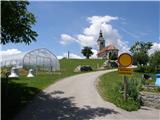
 | Mala voda - Koreno
Koreno (also known as Korena) is a 729 m high hill located north of Horjul. From the summit, which features a large cross, the church of St. Moho...
1 h 15 min |
 | Srednja vas - Koreno
Koreno (also known as Korena) is a 729 m high hill located north of Horjul. From the summit, which features a large cross, the church of St. Moho...
1 h 20 min |
 | Sora - Hom (steep past cemetery)
Hom is a 715 m high peak that rises steeply southwest of the village of Sora. From the summit, which is partly forested, there is a beautiful vie...
50 min |
 | Grgar - Sveta Gora (by road)
Sveta Gora is known mainly among believers and locals. It is a well-known pilgrimage center above Nova Gorica. Believers come here from all over ...
1 h 15 min |
 | Spodnje Pirniče - Grmada (Kovačeva steza)
Grmada is a 676-meter-high mountain located west of the much more visited Šmarna gora. From the summit, which has a small takeoff area, a beautif...
1 h 10 min |
 | Briše - Mali vrh
West of Polhov Gradec, between the rivers Mala voda and Velika Božna, lies the 708-meter-high hill known as Mali vrh. From the grassy summit, whi...
1 h 5 min |
 | Grgar - Vodice (by road)
Vodice (according to some records also Sveti Jakob) is a peak on the western part of the Banjška planota plateau. From the summit, which features...
1 h 15 min |
 | Marof pri Pišecah - Veliki Špiček
Veliki Špiček is the highest peak of Brežice municipality. From the top a nice view spreads towards the south and east. Most of Brežice municipal...
1 h 10 min |
 | Polhov Gradec (Božna) - Mala Grmada (via Sveta Uršula)
Mala Grmada is an 853-meter-high peak located southwest of the slightly higher Polhograjska Grmada. From the summit, a beautiful view opens up ov...
1 h 10 min |
 | Rakovnik - Sveti Florijan (Tehovec) (via Breznik)
The Church of St. Florijan is a subsidiary church located in the village of Tehovec above Medvode. From the church, first mentioned in 1548, a ni...
1 h 20 min |
 | Spodnja Idrija - Cerkovni vrh
Cerkovni Vrh rises broad-shouldered above Spodnja Idrija. From the summit, beautiful views open up onto local peaks such as Kobalove Planine, Jel...
1 h 15 min |
 | Kamnik - Visoka špica (via Krniška gora)
An indistinct but clearly visible forested hill above Kamnik from everywhere. Due to the slightly lower Čokl, on which Kamnik Castle stands, it i...
1 h |
 | Brezovica - Sveti Primož in Felicijan (Jamnik)
The Church of St. Primož and Felicijan at Jamnik is located on a scenic grassy ridge rising between Kropa and Podblica. From the church or its ne...
1 h 20 min |
 | Ribenski most - Tolsti vrh (Talež)
Tolsti vrh is an 883 m high hill located south of Bled, more precisely above the Talež hunting lodge. From the summit, which descends steeply tow...
1 h 15 min |
 | Selski most - Tolsti vrh (Talež)
Tolsti vrh is an 883 m high hill located south of Bled, more precisely above the Talež hunting lodge. From the summit, which descends steeply tow...
1 h 15 min |
 | Jasen - Ahac
Ahac (or Sv. Ahac) is a 799-meter-high peak located east of Ilirska Bistrica. The summit hosts a summit logbox, a cross, and ruins of the former ...
1 h |
| Vrbovo - Ahac
Ahac (or Sv. Ahac) is a 799-meter-high peak located east of Ilirska Bistrica. The summit hosts a summit logbox, a cross, and ruins of the former ...
1 h |
 | Puščava - Lobnikov vrh
Lobnikov vrh is a forested peak above the Dravska dolina valley, located between the settlements of Fala and Ruta. From the east, due to its remo...
1 h 20 min |
| Fala Grad - Lobnikov vrh
Lobnikov vrh is a forested peak above the Dravska dolina valley, located between the settlements of Fala and Ruta. From the east, due to its remo...
1 h 15 min |
 | Izlake (Medijske toplice) - Vrhija (via Podlipovica)
Vrhija is a 648-meter-high hill located west of Izlake and east of Kolovrat. It lies between Kalanov hrib and Kolovraška reber, viewed from the N...
1 h 15 min |
 | Log - Pečke (by road)
Pečke is an easily accessible peak that has seen fewer visitors lately, located north of the main Pohorje ridge. It gets more visits only on May ...
1 h 5 min |
 | Adergas - Apnišče (via Šterna)
Apnišče is a 740 m high mountain between Možjanca and Štefanja gora. It is the highest point of the Šenčur municipality. The forested summit offe...
1 h |
 | Dvor - Kucelj above Polhov Gradec (on marked path)
Kucelj is a somewhat less known peak located between Polhov Gradec and Dvor pri Polhovem Gradcu. From the 705-meter-high summit, a view opens tow...
1 h |
| Dvor - Kucelj above Polhov Gradec (on unmarked path)
Kucelj is a somewhat less known peak located between Polhov Gradec and Dvor pri Polhovem Gradcu. From the 705-meter-high summit, a view opens tow...
1 h |
| Polhov Gradec - Kucelj above Polhov Gradec (via Ravnek)
Kucelj is a somewhat less known peak located between Polhov Gradec and Dvor pri Polhovem Gradcu. From the 705-meter-high summit, a view opens tow...
1 h |
 | Jamce - Podrta gora above Ajdovščina
Podrta gora above Ajdovščina, also Podrta gora above Šturje, is a mountain rising above the Vipava Valley. Some time ago, a large piece of wall b...
1 h 20 min |
 | Selca - Sveti Križ above Selca
The Church of the Holy Cross above Selca is situated on a panoramic hill from which a beautiful view opens up over part of the Škofjeloško hribov...
1 h 15 min |
 | Prevalje - Brinjeva gora (above Prevalje) (via Stations of the Cross)
Brinjeva gora is a popular excursion spot for Prevalje locals, located between the Meža River and Zelenbreški Stream. On the summit stands a smal...
1 h |
| Prevalje - Brinjeva gora (above Prevalje) (south path)
Brinjeva gora is a popular excursion spot for Prevalje locals, located between the Meža River and Zelenbreški Stream. On the summit stands a smal...
1 h |
| Ravne na Koroškem - Brinjeva gora (above Prevalje)
Brinjeva gora is a popular excursion spot for Prevalje locals, located between the Meža River and Zelenbreški Stream. On the summit stands a smal...
1 h 10 min |
 | Vešter - Vrh soteske (Križna gora)
Vrh soteske is a 735 meters high peak, which is situated on the southwestern part of Križna gora. From the top, which is overgrown by the forest,...
1 h 15 min |
 | Hotavlje - Vrh Slajke
Vrh Slajke is a 790-metre hill above Hotavlje, specifically above the right bank of the Kopačnica. From the summit, where an antenna tower stands...
1 h 15 min |
 | Selca - Lepo brdo
Lepo brdo is a 778-metre hill rising above the Selca and Studeno settlements....
1 h |
 | Sora - Breznik (Boben)
Breznik, also known as Boben, is a 643-meter-high peak situated above the right bank of the Ločnica, more precisely above Sora, Rakovnik, Goričan...
1 h 5 min |
| Rakovnik - Breznik (Boben)
Breznik, also known as Boben, is a 643-meter-high peak situated above the right bank of the Ločnica, more precisely above Sora, Rakovnik, Goričan...
55 min |
 | Zreče (Terme Zreče) - Golek (steep path)
Golek is a 769-meter-high peak located northwest of Zreče. The summit has a logbook box with book and stamp, plus a bench; a short distance (a fe...
1 h 20 min |
 | Deutschfeistritz - Parmaseggkogel (via Kugelberg)
Parmaseggkogel is a 785-meter-high peak between the town of Deutschfeistritz and the municipality of Frohnleiten, northwest of Graz.A cross and s...
1 h 15 min |
 | Borovnica - Planina nad Borovnico (Češnjeva pot)
Planina nad Borovnico is a forested peak with no views, featuring a stamp box. The box is located about 20 meters before the 729-meter summit, wh...
55 min |
 | Marof pri Pišecah - Intermedija (via Velika bukva)
Intermedija is a 662-meter-high peak in the Orlica range. From the summit, there is a beautiful view mainly to the north and northeast, where on ...
1 h 10 min |